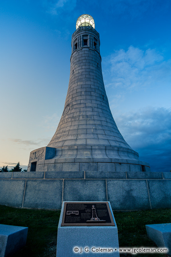
“Faithful Even Unto Death” Veterans War Memorial Tower atop Mount Greylock, Adams, Massachusetts
Tucked away in the far northwestern corner of Massachusetts, Mount Greylock State Reservation deserves special acclaim. For one thing, the park encompasses nearly 20 square miles of territory in Berkshire County, ranking it among the largest parks in Southern New England. And for that matter, Mount Greylock itself is the highest mountaintop in Massachusetts at 3,489 feet. Visitors can take in views of five states from its summit or hike any of the 70 miles of trails that weave up and around the mountain slopes. Everything about this park exists on a much larger scale than what we’re generally accustomed to in New England’s relatively crowded southern states.
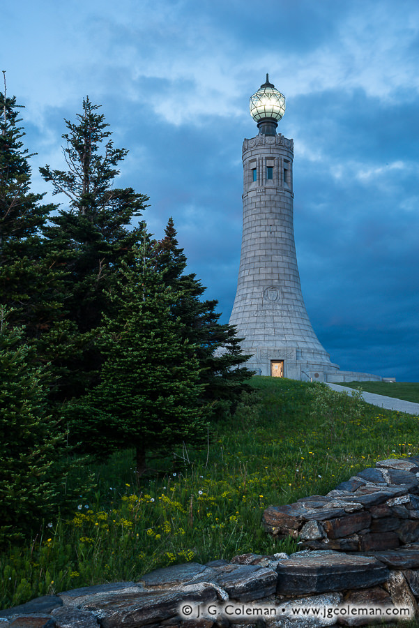
“Greylock Summit” Veterans War Memorial Tower atop Mount Greylock, Adams, Massachusetts
I could go on and on about Mount Greylock in general, but my focus in introducing my piece, “Faithful Even Unto Death”, is the Veterans War Memorial which stands atop the mountain summit. Built in 1933 to honor the soldiers of World War I, the beautiful 93-foot granite tower looks like some ancient, mythologized lighthouse that you might awe over in a history book. Indeed, just like a maritime lighthouse, a large globe at the monument’s peak glows throughout the night and is said to be visible from the surrounding hills up to 70 miles away. And for the curious minds out there, the name of my image is excerpted from an inscription on one of the memorial plaques which says of the fallen soldiers that “they were faithful even unto death”.
Purchase a Fine Art Print or Inquire About Licensing
“When we try to pick out anything by itself,” wrote renowned naturalist, John Muir,” we find it hitched to everything else in the Universe.” Such is the case with that territory we call The Berkshires. From the standpoint of geology, determining where the Berkshires begin and end is actually a bit more complicated than determining which county of Massachusetts they are named after. Take Mount Greylock, for instance, which has always been popularly thought of as the grandest mountain of the Berkshires. In reality, it’s part of the neighboring Taconics, a separate mountain range to the west of The Berkshires which occasionally spills over into Berkshire County. But even the true Berkshires are actually a vast southern stretch of the Green Mountains that we usually associate with Vermont.
So, for the third and final installment of Journey Into the Berkshires, we’re going to do something a bit different: journey out of the Berkshires, ending our travels at some of the landscapes that lie in the periphery of these iconic mountains of Massachusetts.
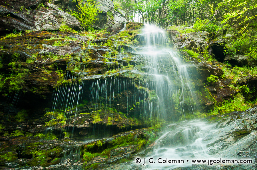
Race Brook Falls Sheffield, Massachusetts
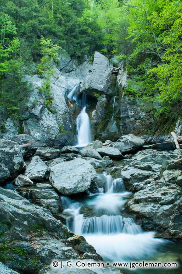
In the woodlands of Sheffield, only a few miles north of the Connecticut state line, Race Brook courses through the heart of the 1,300-acre Mount Everett State Reservation. The stream tumbles feverishly down from the heights of the Reservation’s namesake mountain, draining the forests that flank its southern slope. Unlike nearby Bash Bish Brook, Race Brook doesn’t seem to have a place in the legends of the Berkshires; there aren’t any ancient tales of romance or tragedy to be found in the books, even if that’s only because time has swallowed them up. But what Race Brook may lack in provenance, it more than makes up for with striking scenery.
Take my new piece, Falls of Mount Everett (at top), in which Race Brook leaps frantically from a precipice, churning to whitewater before crashing into the bedrock below. Patches of vibrant moss mottle the surface of surrounding bedrock, generously nourished by a stray portion of the brook that escapes the falls, instead trickling from the adjacent ledge in fine strands. This is only one of several cataracts to be found along Race Brook, for it is in this area that the stream descends nearly 1,000 feet down the steep slopes of the highlands before joining with Dry Brook in the valley below.
Mount Everett State Reservation is just one of several expanses of protected wildlands in the far-southwestern corner of Massachusetts. Just a few miles to the west is the 4,000-acre Mount Washington State Forest and the smaller, but much renowned, Bash Bish Falls State Park. Adjoining Mount Everett to the north, we find the 1,100-acre Jug End State Reservation. But even though there’s plenty to see here, we aren’t sticking around. Instead, we’re following the mountains south, departing Berkshire County and heading into the Nutmeg State.
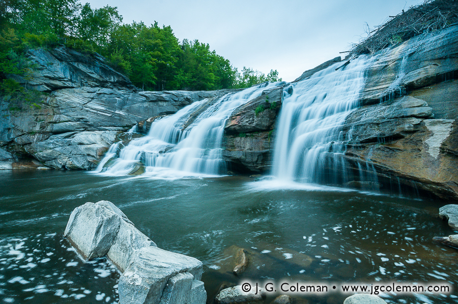
Great Falls of the Housatonic Canaan, Connecticut
The mountains and hills of Connecticut’s northwestern corner are oftentimes called “The Northwest Hills”, a name which could understandably be mistaken for a simple, literal description. Some folks are partial to the view that the Northwest Hills are just as much a part of The Berkshires as the mountains further north in Massachusetts. Indeed, there doesn’t seem to be any physical feature of the landscape that we could pinpoint as the clear place to delineate The Berkshires from the Northwest Hills; where does one draw the line? Even still, there are many that scoff at the notion that The Berkshires extend as far as 20 or 30 miles south into Connecticut, encompassing towns such as New Fairfield, Roxbury, Wolcott and Burlington. These are all hilly towns, for sure, but it’s difficult to equate their hilly terrain with an iconic mountain range that lies far away in the namesake county of a different state. And on that note, if The Berkshires are contained mostly in Berkshire County, Massachusetts, then shouldn’t the mountains in northwestern Connecticut’s Litchfield County be dubbed “The Litchfields”? Well, pretty close: the Northwest Hills are perhaps more romantically dubbed “The Litchfield Hills”.
Our jaunt into the Litchfield Hills brings us only about 5 miles south of the Massachusetts border into the town of Canaan, Connecticut. Encompassing 33 square miles with barely over 1,000 people, the rugged terrain and expansive, unpopulated wildlands of Canaan possess an aesthetic that is practically indistinguishable from that found up north in the Berkshires. Even the bedrock that underlies the landscapes of Canaan is part and parcel to the same vast veins of pale limestone and marble that we find exposed at Bash Bish Falls, Tannery Falls, Wahconah Falls, Race Brook and other rugged gorges throughout Western Massachusetts.
But there’s one major way in which Canaan’s Great Falls differs from those scenic waterfalls of the Berkshires: it’s much larger. Located in the Falls Village section of town, this impressive cataract sees the full, 100-foot breadth of the Housatonic River dumped 60 feet over a massive ledge of time-worn limestone. A 60foot drop is by no means unheard of among waterfalls of Southern New England, but most of those are formed along the course of modest woodland brooks, not sizable rivers like the Housatonic. During high-water episodes, more than 18,000 gallons of water crash angrily over Great Falls every second; no other waterfall in Southern New England is so voluminous. But when you take a look at my new piece, Great Falls on the Housatonic (above), you’ll find it portrayed during a time of much-reduced waterflow, the river streaming swiftly down marble cliffs beneath the dying light of dusk.
Only a few hundred feet upstream of Great Falls, the Falls Village Dam diverts a significant portion of the Housatonic’s volume for power generation. This leaves the waterfall starved for water during drier times of year. During snow melts and spring rains, though, the Housatonic swells far beyond the needs of the hydroplant and immense torrents bypass the dam and crash magnificently over Great Falls. So although seeing this waterfall in all of its crushing glory requires somewhat precise timing, Great Falls is nonetheless an impressive sight during just about any time of year.
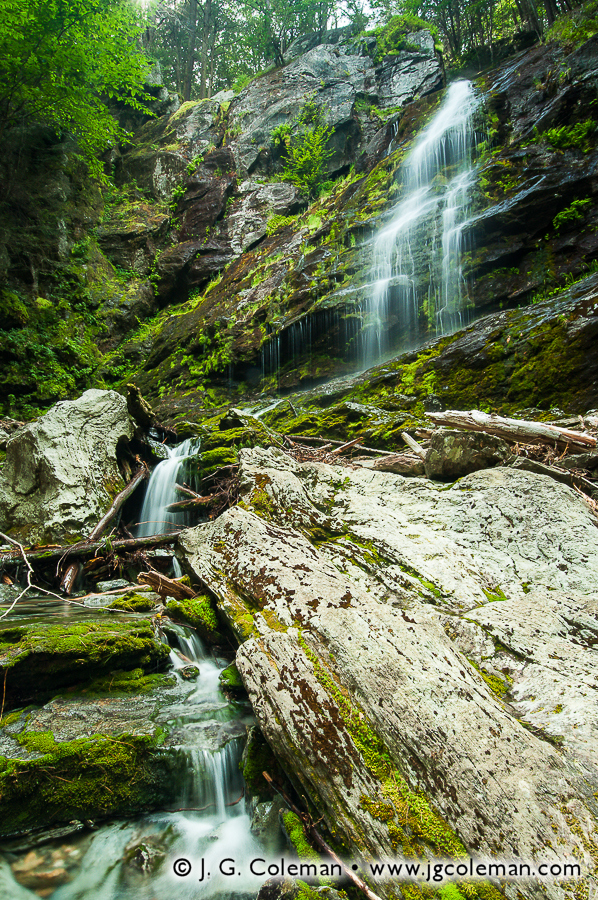
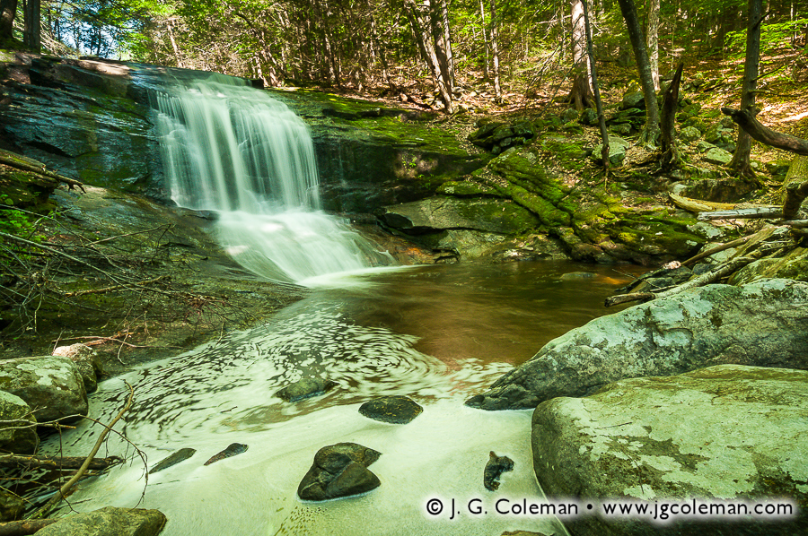
Chapel Falls Ashfield, Massachusetts
Our journey from the heart of the Berkshires to the borderlands of those famed mountains doesn’t end in Connecticut, though. Instead, we’re going to leave the foot of Great Falls and head northeast about 50 miles, back into the highlands of Massachusetts for a quick stop in the forests of Ashfield. It is here that Chapel Brook meanders through the gently sloping woodlands of Pony Mountain, keeping a mostly calm and reserved demeanor until spilling over a series of abrupt rock ledges to form Chapel Falls. My new piece, “On the Flank of Pony Mountain”, brings us into the Chapel Brook gorge where the waterfall plunges over a rock outcropping into the pool below. Foam churned up by the falls swirls along the periphery of the brook, ever cloaked as it is in the thick shadows of the forest canopy despite the rather sunny, cloudless day overhead.
Protected as part of Chapel Brook Reservation, Chapel Falls lies within Franklin County, some 10 miles east of the Berkshire County line. But even if it doesn’t fall within the political boundaries of Berkshire, Chapel Falls and the vast 40-square-mile expanse of Ashfield are typically described as laying within the eastern foothills of the Berkshires. Of course, merely experiencing the furrowed and densely forested terrain of this region is indication enough that it has inherited more than a bit of the character of the mountainlands to the west.
Until Next Time…
With that, we conclude our Journey Into the Berkshires, even if there’s still plenty more to see in these scenic mountainscapes of Western Massachusetts. Looking back at the three-part series of new prints, though, there’s little doubt that plenty of ground has been covered. We’ve traveled to the northern Berkshires to peer out from the heights of Mount Greylock, marveled at a sun halo from the grounds of Natural Bridge and stood at the foot of Tannery Falls. In the central Berkshires, we delved deep into the legend of Wahconah Falls. Bash Bish Falls and Race Brook Falls were welcome stops in the southern Berkshires. We’ve even managed to push into the neighboring highlands to take in the views at Chapel Brook and headed down the Housatonic River to see the Great Falls in Connecticut’s northwest.
“There is something about the scenery,” wrote Clark Bryan in his 1887 Book of Berkshire,” that imparts a quietude, a repose, a freedom from distraction, a healing with the balm of Dame Nature. The unequaled harmony of the surroundings exhales an influence that enraptures the beholder, and creates within him an inward form of the external.” Bryan’s time has long since past, just as the way of life in the Berkshires has surely changed since he penned those words. But the modern-day visitor to this western mountain spine of New England will discover that these forested mountains are timeless in their allure, possessing a beauty and serenity that has persisted through centuries untold. The pieces I’ve introduced with Journey Into the Berkshires are momentary visions of these enduring wildlands; vignettes of a rugged and subtly sublime landscape that I offer to you with the hopes that they can strike the same chords of awe and appreciation that inspired them.
Within the thousand square miles of Southern New England known as The Berkshires, 19th-century author Clark Bryan found no shortage of inspiration for his 1887 travel guide, Book of Berkshire. “There is a marvelous blending of masterpieces of natural beauty, of the wild and the picturesque,” he explained. “Though there is civilization, somehow a wilderness is not out of place, and though the surface of the earth be ruffled and rugged, often forest-covered and untillable, yet it impresses one as the fittest dwelling-place of the highest civilization.” The mountain spine of Western Massachusetts has retained the same invigorating character that Bryan applauded more than a century ago. Most of this vast and majestic territory is dominated by dense woodlands that soften the rocky contours of its mountains and cast its winding rivers into shadow.
Last week, for the first installment of my three-part series Journey Into the Berkshires, I introduced you to a few of my latest fine art prints featuring the most time-honored natural landmarks of the region. We began at the lofty heights of Mount Greylock, then descended into the shadowy, woodland chasm of Bash Bish Falls. In this second installment, our Berkshire odyssey continues as we delve into places that are perhaps lesser known, but equally stirring and graced with uncommon wild beauty.
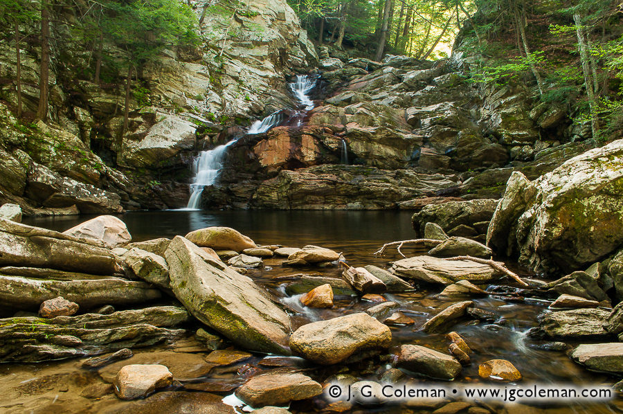
Wahconah Falls Dalton, Massachusetts
We begin our journey by venturing into my new piece, Nessacus Fortune (top), which brings us into the geographic heart of the Berkshires where Wahconah Brook is churned to whitewater as it spills over successive tiers of ancient bedrock. In the foreground, the lively brook fans out as it slips around slabs of fragmented marble. Hardy cliff-side trees and a glancing taste of the distant, glowing forest canopy remind us that this exquisite landscape of stone is actually crowded by dense woodlands.
Known as Wahconah Falls, there is an interesting Native American legend associated with this 40-foot cascading waterfall that comes to us from several different books published throughout the late 1800s. In fact, the story of Wahconah has been written, re-written and re-interpreted so many times that it’s difficult to pin down any one version of the story as the “original”. In some cases, the story is condensed into a single paragraph, while in other books it is related in long form and occupies nearly ten pages. Rarely does one find a local legend that is told with such diversity of size and detail. And, since it is so eloquently related elsewhere at great length, I offer here a fairly abbreviated account.
From time to time, though, warriors tired from battle would slip into the hills and stumble upon Miacomo’s village. They were always welcome to stay for some time and rest, though none of them proved so problematic as a warrior named Nessacus. During his stay at the village, Nessacus fell deeply in love with Wahconah and eventually asked the chief for permission to marry her.
Chief Miacomo favored Nessacus, but he was urged by the tribal priest, Tashmu, to offer Wahconah’s hand in marriage to an old Mohawk warrior instead. Tashmu insisted that such an arranged marriage would promote an alliance between Miacomo’s tribe and the neighboring Mohawk tribe. Secretly, though, the priest simply craved the political influence he would gain under such an alliance; he had little regard for the desires of Wahconah and no interest in the likes of Nessacus.
The tribe looked to Miacomo for a ruling of some kind, but he was unable to come to a decision even after days of consideration. Amidst growing tensions and the prospect of a duel, Tashmu intervened and explained that he had visions in which a vacant canoe would be launched from the foot of the nearby waterfall and left to drift downstream to a point where a large boulder divided the waters of the river equally. Nessacus and the old Mohawk would stand on opposite sides of the river near the boulder and, depending upon which side of the boulder the canoe drifted, that suitor would win Wahconah’s hand.
Little did the tribespeople know, Tashmu and the Mohawk secretly tried to rig the event by digging out the stream bed to hasten the flow of water on the Mohawk’s side of the boulder. Surely, they believed, the swifter current would draw the canoe towards the Mohawk and victory would be guaranteed. The next day, the tribe assembled to watch as Nessacus and the Mohawk assumed their positions on either side of the boulder. A canoe was released upstream and the two suitors stood in wait as it floated down the river, approaching ever closer. The Mohawk’s jaw nearly dropped, however, as he watched the canoe take an unswerving course for the opposite side of the boulder, ensuring that love would prevail and Nessacus and Wahconah would be wed. Baffled, the Mohawk set off into the forest on his way back to his home village. Tashmu, surely just as awestruck at the development, stormed out of the village shortly afterwards.
Various renderings of the tale differ on the point of how Tashmu and the Mohawk somehow failed despite their best efforts at cheating. In some cases, no attempt is made to explain the outcome, leaving us to believe that it was the Great Spirit, or perhaps the magical strength of true love, that managed to draw the canoe towards Nessacus. In other instances, it is suggested that Nessacus may have anticipated that his competitors would cheat, affording him an opportunity to secretly counter their efforts. One version of the story recounts that, days after the event, a tribesman discovered evidence that Nessacus had affixed a makeshift rudder to the bottom of the canoe, ensuring that it would steer towards his own side of the boulder regardless of the tug of the currents. Yet when the man reported his findings to Chief Miacomo, the elder didn’t seem especially concerned…
Nessacus and Wahconah were happily wed, and so it is that Wahconah Falls draws its name from a tale of romance. But what ever became of Tashmu? Most versions of the story agree that he was infuriated after his botched attempt at gaining political influence. Hungry for revenge, Tashmu traveled for a few days until reaching the nearest English army, offering to guide them to Miacomo’s village. Incidentally, the English didn’t act upon Tashmu’s invitation, for they were low on supplies and needed to head back east. But Native American spies had caught on to Tashmu’s treachery and brought word back to Miacomo and Nessacus that their hidden location in the hills had been revealed to the English and was no longer safe. Tashmu was swiftly hunted down and put to death for treason, some say by Nessacus himself. The village was presumably moved shortly afterwards, though if any of the English ever did discover the new location, that information has been lost to history.
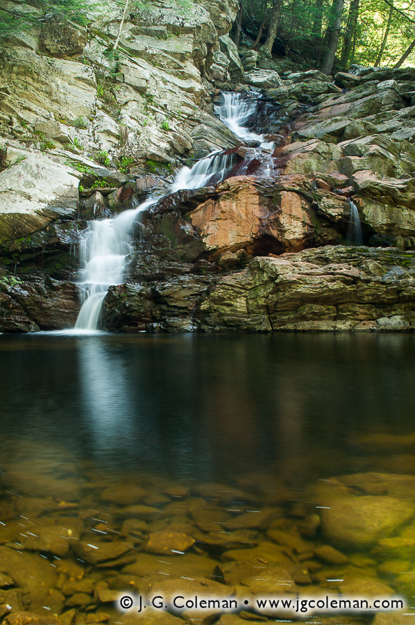
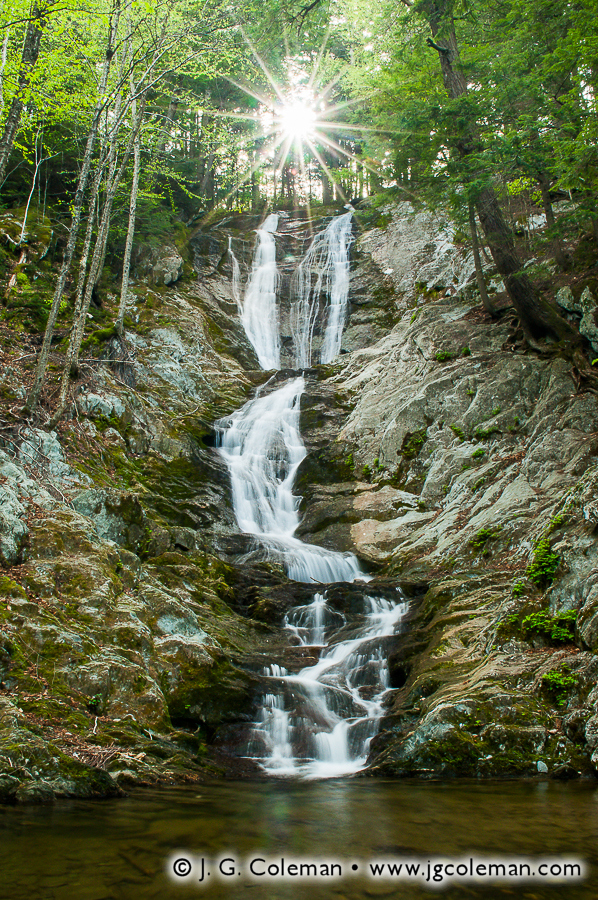
Tannery Falls Florida, Massachusetts
Our next stop brings us further north to Savoy, a rural town of 36 square miles and just over 700 people. Practically empty relative to most of Southern New England, it is no surprise that the vast majority of Savoy is blanketed with sprawling expanses of unbroken woodlands. In fact, roughly a third of the town’s entire land area is preserved within four state forests!
Savoy Mountain State Forest is the namesake open space, occupying more than 10,000-acres of mountainous wilds in the heart of the town. It is here that we find Tannery Falls, a towering waterfall on Ross Brook that is featured in my new work, Sanctuary at Savoy Mountain. As we explore this piece, we are drawn at first to the blazing sun star piercing the forest canopy at the precipice of the waterfall. From there, Tannery Falls begins its first descent, fanning out into two broad sheets as it slides down a smooth marble rock face. Successive whitewater cascades form the lower half of the fall, heaving the waters of Ross Brook from side to side until reaching a calm, dark pool below. Tannery Falls is surely one of the most aesthetically remarkable waterfalls in the Berkshires, perhaps even rivaling the much acclaimed falls at Bash Bish.
Of course, it’s easy to forget that my actual experience at Tannery Falls didn’t necessarily comport with the image of peaceful solitude that you might envision when you look at Sanctuary. During my visit in May, the mosquitoes had emerged en masse and were so unforgiving in their relentless assault that it required an act of willpower just to stand in one spot long enough to compose a shot. By the time I was packing up my camera gear, every bit of exposed skin was aching from their ceaseless bites. Truth be told, though, the beauty of Tannery Falls is arresting; so much so that I was more than obliged to offer a hearty meal to the local mosquito population in return for the privilege of producing Sanctuary at Savoy Mountain.
But a word of advice: if you should ever find yourself traveling through Savoy in search of springtime sanctuary, just be sure to remember insect repellent and long sleeves…
A Halo at Natural Bridge? North Adams, Massachusetts
Natural Bridge State Park may get less attention than nearby Mount Greylock, but that’s probably just because folks don’t know what they’re missing. The namesake feature of this 48-acre park is a large, natural arch comprised entirely of marble; the only such arch on the continent. Furthermore, visitors that walk a short way upstream from the arch will find the only dam on the continent made entirely of marble. For my own part, though, I was most intrigued by the 60-foot deep gorge through which Hudson Brook flows beneath the arch. The narrow, winding gorge brought to my mind the iconic slot canyons of the American Southwest, except that instead of red-rock sandstone, the smooth canyon walls of Natural Bridge are carved entirely from pale gray, half-billion-year-old marble bedrock. Before I saw the canyon of Natural Bridge, I never would’ve imagined that such a place existed in New England.
That being said, you might be surprised to learn that my piece from Natural Bridge State Park, titled Halo Over North Adams, doesn’t portray any of the impressive attractions that I’ve just described. As fate would have it, what were originally partly cloudy skies had cleared while I was en route to the park, leaving me instead with cloudless skies and harsh, direct sunlight that wasn’t especially conducive to photographing the various marble rock formations. But just when I thought that Natural Bridge wouldn’t yield any particularly interesting images, Mother Nature conspired to reveal beauty in a most unexpected way.
Believing that interesting opportunities for photography might be found within the shadows of the gorge, where harsh sunlight couldn’t penetrate, I and a fellow shooter ventured up Hudson Brook. We eventually found ourselves in a shallower end of the narrow marble canyon, flanked on both sides by vertical cliff faces that climbed some 25 feet above our heads to gorge rim. The terrain leading further into the canyon proved impassable on foot, however, dashing any hopes of making it into the depths we had originally set out to access. But as we lingered for a moment before turning back, we happened to glance upwards. Only a narrow sliver of the sky was visible from the canyon floor, but we were amazed to see what appeared to be a strange rainbow emanating from the Sun. I wondered if perhaps we weren’t just experiencing some peculiar optical illusion caused by sunlight funneling into such a narrow crevice, but as we eagerly made our way out of the canyon and into the open parkland, we gazed up in amazement at a hazy halo that fully encircled the Sun.
Neither of us had ever witnessed such a phenomenon and had no idea how long it might last, so we wasted no time composing several frames of the otherworldly scene. My favorite piece from that fortuitous shoot, Halo Over North Adams, portrays the broad halo as it appeared over the landscaped park road of Natural Bridge. The winding road, trees, and monolithic rock outcropping all lend a much needed sense of scale to this image, illustrating the colossal breadth of the halo as it appeared overhead.
Known most commonly as “sun halos”, these 360° rainbows form only when sunlight passes though atmospheric ice crystals under just the right circumstances. Although they are fairly uncommon, they are by no means unheard of, for whenever they do happen to appear over a heavily populated area, they tend to generate plenty of commotion. Unusual atmospheric phenomena such as sun halos and rainbows are the true wildcards of landscape photography; photogenic occurrences that are just as elusive as they are impressive. There is really no way to conclusively predict them, and if you don’t already have your camera in-hand once you’ve spotted them, you’re probably too late!
The Journey Continues…
With the second installment of Journey Into the Berkshires coming to a close, we’ve already explored a good deal of Massachusetts’ mountainous west through an array of my new works. If I could venture to draw any underlying thread from the images and stories here, it is that the wildlands of the Berkshires, in the true character of wildness, have no regard for the narrow expectations of man. Against all odds, these mountains saw fit to grant Nessacus with victory. These mountains summoned hordes of mosquitoes to try and drive this humbled photographer out of the valleys of Savoy. These mountains, it seems, can even reach to the ceiling of the heavens and affix a halo to the Sun itself!
But perhaps it’s this vein of unpredictability that we find in the Berkshires which draw us into these remote and rugged places. As author Robert MacFarlane reminds us: “At bottom, mountains, like all wildernesses, challenge our complacent conviction – so easy to lapse into – that the world has been made for humans by humans. Most of us exist for most of the time in worlds which are humanly arranged, themed and controlled. One forgets that there are environments which do not respond to the flick of a switch or the twist of a dial, and which have their own rhythms and orders of existence. Mountains correct this amnesia.”
Be sure to join me in a few weeks for the third and final installment of Journey Into the Berkshires, when we’ll come down from the heart of this grand mountain range and explore the natural wonders that abound in its foothills and borderlands.
“In most mountainous regions, there is a tiresome similarity among the mountains, the hills, the forests, the valleys, the streams and the landscape, but this is not so in the Berkshire,” wrote Clark W. Bryan in his 1887 work, Book of Berkshire. “Here… the mountains and hills, on every hand, are fashioned in the most varied styles, the valleys are no two alike, and the scenery everywhere passes before the eye of the traveler in the richest and most lavish profusion of dissimilar characteristics.” Well over a century has passed since these words were penned, but the mountain spine of western Massachusetts, known simply as The Berkshires, seems to have retained every bit of the fascinating and scenic character that Bryan discovered so long ago.
Over the next few weeks, I’ll be taking you along on an odyssey through the Berkshire landscapes as I release several new fine art prints in a three-part series I’ve titled Journey Into the Berkshires. We’ll experience some of the region’s most exquisite and awe-inspiring scenery and delve into the fascinating lore that underlies this rural back-country in western Massachusetts. For the first installment of the series, I’ve decided to introduce you to two of the Berkshires most famous natural places; beacons of wild beauty that have inspired travelers and artists for generations.
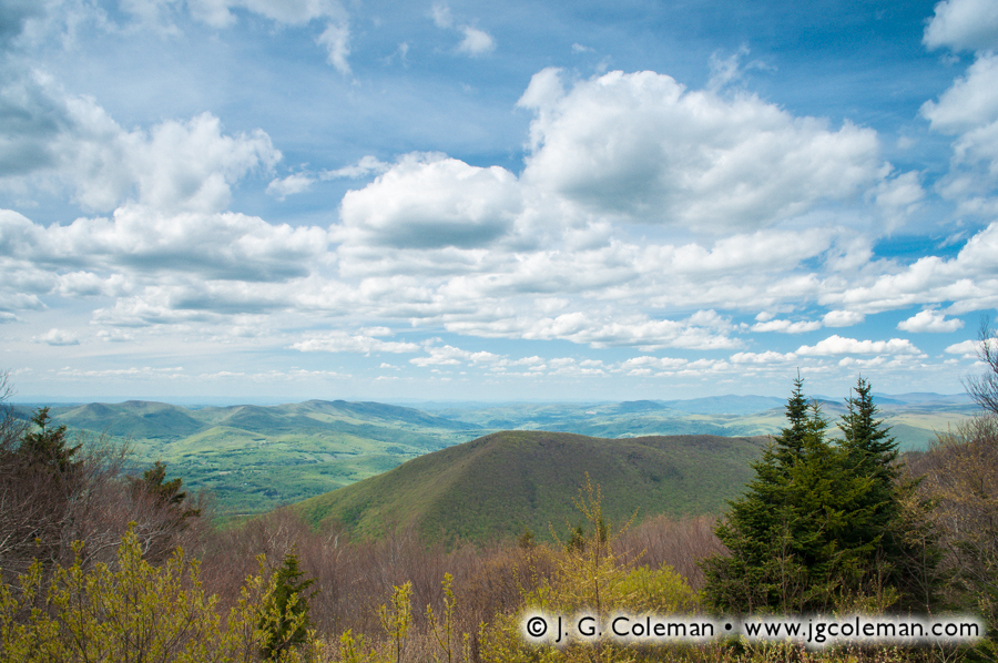
Mount Greylock Adams, Massachusetts
When C. W. Bryan sat down in the 1880s to write about the panoramic views from the summit of Mount Greylock, he began by conceding that “the pen cannot describe the scene”. The perspective from this massive mountain, which climbs more than 2,000 feet over the surrounding valleys and affords 100-mile views into neighboring states, is one of the most impressive in all of Southern New England.
In my new piece, Greylock Vista (above), we are whisked to the upper slopes of Mount Greylock where a grand panorama unfolds before our eyes. The deeply-furrowed expanses of the Berkshires reveal themselves as a majestic procession of broad, forest-laden slopes and rural valleys that stretch to a distant horizon beneath a hazy blue sky ripe with gentle clouds.
Spanning several towns in the far northwest corner of Massachusetts, Mount Greylock reaches a height of just under 3,500 feet above sea level, making it the highest summit in Berkshire County. Indeed, taking in the view from this towering peak has long been considered one of the quintessential aesthetic experiences of the Berkshires. It is no surprise, then, that Mount Greylock was the first swath of territory set aside by the State of Massachusetts in an effort to protect forestland and preserve natural heritage. Created in 1898, Mount Greylock State Reservation has steadily grown since its it inception, now encompassing more than 12,000 acres of rugged land radiating from the summit.
The name, “Mount Greylock”, first appeared in writing in the early 1800s and had become widely-used only a few decades later, but there’s still some measure of mystery as to its origin. Some attribute the name to the gray clouds that occasionally cling to the mountain’s summit, said to resemble locks of gray hair. Other sources claim that the mountain was named in honor of Chief Grey Lock, a Western Abenaki warrior that led several bloody campaigns against the English in Massachusetts during the 1720s. Grey Lock was one of New England’s “most wanted” for a number of years and the colonists made several efforts to hunt him down. The cunning warrior thwarted every attempt, eventually retiring from active warfare and, by all accounts, living to a ripe old age.
Chief Grey Lock spent many of his years on the move between Massachusetts and Vermont, though there doesn’t seem to be any credible story that directly associates him with Mount Greylock. Perhaps it simply seemed fitting to name such an imposing mountain after such an infamous, larger-than-life warrior.
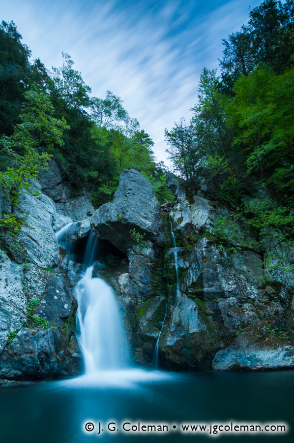
Departing the slopes of Mount Greylock and heading some 40 miles south to the town of Mount Washington, we arrive at the equally-famous and much celebrated Bash Bish Falls. “It is not without a silencing thrill of delight that the cataract of Bashbish greets the vision,” wrote one 19th-century visitor. Another writer dubbed them “the anthem of Nature’s hymn in New England.” Indeed, Bash Bish Falls is the scenic epicenter of the southern Berkshires and the subject of more than a century-and-a-half of paintings, poems and photographs.
But despite the abundance of works inspired by this natural landmark, my piece Bash Bish Twilight nonetheless offers a vista of the falls in an uncommon light: the early hours of morning, before the sun has risen. Illuminated only by soft, reflected light from the sky above, the weathered rock faces of the gorge take on a palette of cool color tones as Bash Bish Brook spills from the uppermost ledges, sending a plume of water careening into the pool below. Above the shadowy forest on the gorge rim, the clouds have been transformed into dreamy wisps with the help of a long shutter speed.
Just as with Mount Greylock, there is a certain degree of mystery regarding how Bash Bish Falls came to be named. Perhaps the simplest explanation is that the name is onomatopoeic: the plunging water is said create a gurgle that vaguely sounds like “bash bish”. However, there is an alternate legend that accounts for the name with a much more intriguing story.
The account tells of a beautiful Native American woman named Bash Bish, who was falsely accused of adultery by an envious member of her tribe. For unknown reasons, the tribe determined that she was guilty and ought to be punished by death. In a gruesome spectacle, she was strapped to a canoe and set adrift down the brook, eventually careening over the waterfall. When the tribe attempted to find Bash Bish’s body, though, they could recover only broken fragments of the canoe. The mysterious lack of a body spooked the tribe, who concluded that she must have been a witch.
Bash Bish was gone, but she had left behind a daughter by the name of White Swan. Over the years following her mother’s death, White Swan had grown to be quite beautiful herself, eventually marrying Whirling Wind, the son of a prestigious chief. The two were deeply in love and all was well for the couple, except for glaring fact that they seemed unable to conceive a child. White Swan, having been eager to bear a child for her husband, was crushed at the realization that it was proving impossible. Fraught with misery, she climbed to the precipice above Bash Bish Falls and jumped, meeting her fate on the same waters that claimed her mother years earlier. What she didn’t realize is that Whirling Wind had secretly followed her; perhaps he thought she had simply gone to the falls to think, and he was hoping to comfort her. He instead arrived just in time to see her jump. Grief-stricken, he too cast himself into rocky waters below. In the aftermath of the tragedy, the tribe pulled the battered body of Whirling Wind from the waters; White Swan was never found. Fleeting images of Bash Bish and White Swan are said to be momentarily visible in the cascading waters of Bash Bish Falls to this day.
But whereas Chief Greylock was undoubtedly a real Abenaki warrior of the 18th-century, there doesn’t seem to be any mention of Bash Bish and White Swan in old records. The legend seems to have emerged out of nowhere in a few obscure sources in the 1950s, always being billed as lore passed down from local tribes. Yet it’s curious that this legend was apparently not prominent enough to make it into Clark Bryan’s Book of Berkshire, published some 70 years earlier in 1880s. Perhaps it’s simply a fantastic story that was dreamed up at some point during the early 20th-century in order to put a mysterious spin on the peculiarly-named landmark. Or maybe… just maybe… there is a vein of truth to this story of love, loss and untimely death in an era before Europeans.
After all, Bash Bish Falls is apparently just as perilous as it is scenic; “the most deadly waterfall in the United States” according to some sources. Whether or not that superlative rings true is probably tough to pin down, but when you consider that over two-dozen people have perished at Bash Bish Falls in recorded history, the facts alone are shocking enough.
On to the Next Journey…
There’s little doubt that the Berkshires are a place of inspiring beauty, and we’ll continue to explore the natural treasures of these mountains through the fine art prints featured in my next installment of Journey Into the Berkshires. But as we’ve already discovered with the tales of Chief Greylock, Bash Bish and White Swan, there’s an ancient and storied history that dwells in these wild expanses of Western Massachusetts. The legends that have grown out of the Berkshires are a captivating and haunting blend of fact and fiction, of the real and the surreal. With my photographic depictions of this rugged territory, I seek not only to capture the enchanting beauty of the landscape, but also to instill within my works a subtle bridge into the past… into the primeval contours of the land… into the enigmatic generations of souls that have loved, lost, lived and died in these mountains for untold centuries.