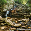

Race Brook Falls, Mount Everett State Reservation, Sheffield, Massachusetts
© 2013 J. G. Coleman
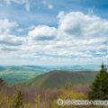
“When we try to pick out anything by itself,” wrote renowned naturalist, John Muir,” we find it hitched to everything else in the Universe.” Such is the case with that territory we call The Berkshires. From the standpoint of geology, determining where the Berkshires begin and end is actually a bit more complicated than determining which county of Massachusetts they are named after. Take Mount Greylock, for instance, which has always been popularly thought of as the grandest mountain of the Berkshires. In reality, it’s part of the neighboring Taconics, a separate mountain range to the west of The Berkshires which occasionally spills over into Berkshire County. But even the true Berkshires are actually a vast southern stretch of the Green Mountains that we usually associate with Vermont.
So, for the third and final installment of Journey Into the Berkshires, we’re going to do something a bit different: journey out of the Berkshires, ending our travels at some of the landscapes that lie in the periphery of these iconic mountains of Massachusetts.
Race Brook Falls
Sheffield, Massachusetts
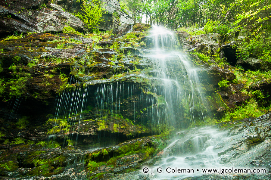
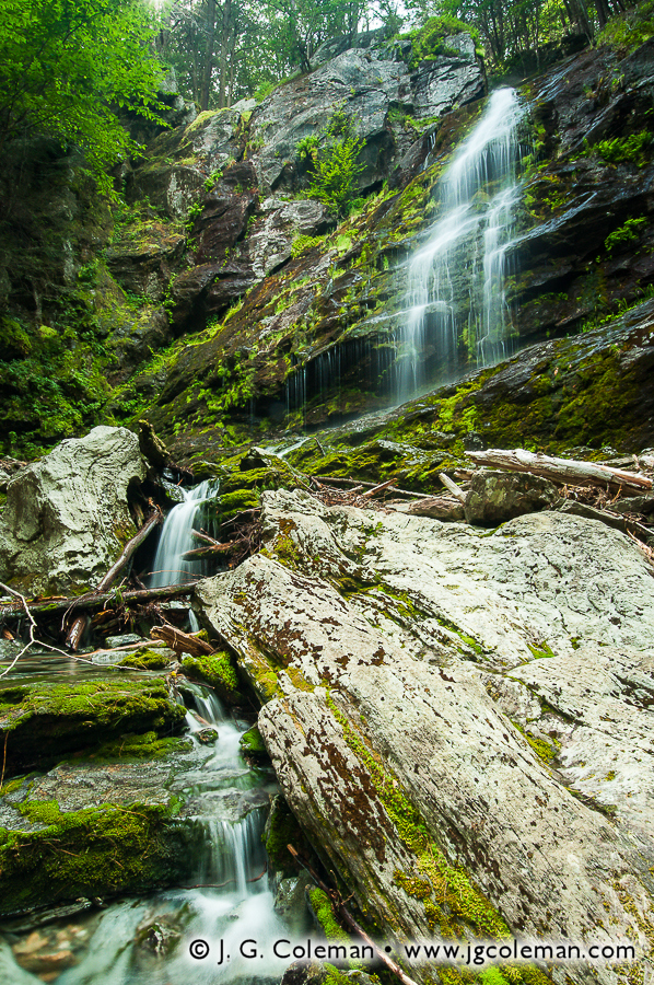
In the woodlands of Sheffield, only a few miles north of the Connecticut state line, Race Brook courses through the heart of the 1,300-acre Mount Everett State Reservation. The stream tumbles feverishly down from the heights of the Reservation’s namesake mountain, draining the forests that flank its southern slope. Unlike nearby Bash Bish Brook, Race Brook doesn’t seem to have a place in the legends of the Berkshires; there aren’t any ancient tales of romance or tragedy to be found in the books, even if that’s only because time has swallowed them up. But what Race Brook may lack in provenance, it more than makes up for with striking scenery.
Race Brook Falls, Mount Everett State Reservation, Sheffield, Massachusetts
© 2013 J. G. Coleman
Take my new piece, Falls of Mount Everett (at top), in which Race Brook leaps frantically from a precipice, churning to whitewater before crashing into the bedrock below. Patches of vibrant moss mottle the surface of surrounding bedrock, generously nourished by a stray portion of the brook that escapes the falls, instead trickling from the adjacent ledge in fine strands. This is only one of several cataracts to be found along Race Brook, for it is in this area that the stream descends nearly 1,000 feet down the steep slopes of the highlands before joining with Dry Brook in the valley below.
Mount Everett State Reservation is just one of several expanses of protected wildlands in the far-southwestern corner of Massachusetts. Just a few miles to the west is the 4,000-acre Mount Washington State Forest and the smaller, but much renowned, Bash Bish Falls State Park. Adjoining Mount Everett to the north, we find the 1,100-acre Jug End State Reservation. But even though there’s plenty to see here, we aren’t sticking around. Instead, we’re following the mountains south, departing Berkshire County and heading into the Nutmeg State.
Great Falls of the Housatonic
Canaan, Connecticut
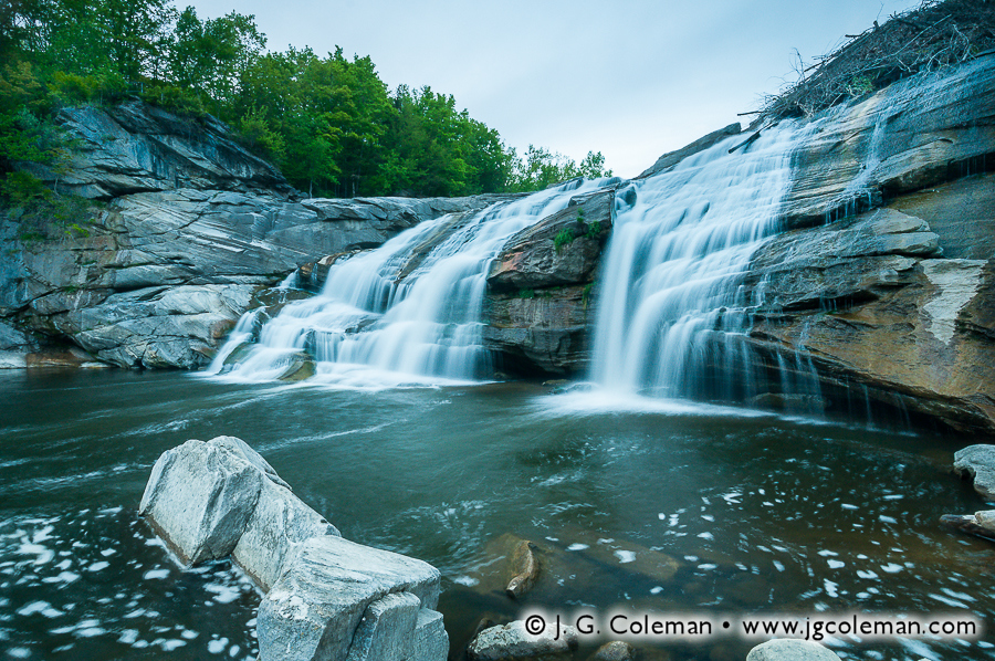
The mountains and hills of Connecticut’s northwestern corner are oftentimes called “The Northwest Hills”, a name which could understandably be mistaken for a simple, literal description. Some folks are partial to the view that the Northwest Hills are just as much a part of The Berkshires as the mountains further north in Massachusetts. Indeed, there doesn’t seem to be any physical feature of the landscape that we could pinpoint as the clear place to delineate The Berkshires from the Northwest Hills; where does one draw the line? Even still, there are many that scoff at the notion that The Berkshires extend as far as 20 or 30 miles south into Connecticut, encompassing towns such as New Fairfield, Roxbury, Wolcott and Burlington. These are all hilly towns, for sure, but it’s difficult to equate their hilly terrain with an iconic mountain range that lies far away in the namesake county of a different state. And on that note, if The Berkshires are contained mostly in Berkshire County, Massachusetts, then shouldn’t the mountains in northwestern Connecticut’s Litchfield County be dubbed “The Litchfields”? Well, pretty close: the Northwest Hills are perhaps more romantically dubbed “The Litchfield Hills”.
Great Falls, Canaan, Connecticut
© 2013 J. G. Coleman
Our jaunt into the Litchfield Hills brings us only about 5 miles south of the Massachusetts border into the town of Canaan, Connecticut. Encompassing 33 square miles with barely over 1,000 people, the rugged terrain and expansive, unpopulated wildlands of Canaan possess an aesthetic that is practically indistinguishable from that found up north in the Berkshires. Even the bedrock that underlies the landscapes of Canaan is part and parcel to the same vast veins of pale limestone and marble that we find exposed at Bash Bish Falls, Tannery Falls, Wahconah Falls, Race Brook and other rugged gorges throughout Western Massachusetts.
But there’s one major way in which Canaan’s Great Falls differs from those scenic waterfalls of the Berkshires: it’s much larger. Located in the Falls Village section of town, this impressive cataract sees the full, 100-foot breadth of the Housatonic River dumped 60 feet over a massive ledge of time-worn limestone. A 60foot drop is by no means unheard of among waterfalls of Southern New England, but most of those are formed along the course of modest woodland brooks, not sizable rivers like the Housatonic. During high-water episodes, more than 18,000 gallons of water crash angrily over Great Falls every second; no other waterfall in Southern New England is so voluminous. But when you take a look at my new piece, Great Falls on the Housatonic (above), you’ll find it portrayed during a time of much-reduced waterflow, the river streaming swiftly down marble cliffs beneath the dying light of dusk.
Only a few hundred feet upstream of Great Falls, the Falls Village Dam diverts a significant portion of the Housatonic’s volume for power generation. This leaves the waterfall starved for water during drier times of year. During snow melts and spring rains, though, the Housatonic swells far beyond the needs of the hydroplant and immense torrents bypass the dam and crash magnificently over Great Falls. So although seeing this waterfall in all of its crushing glory requires somewhat precise timing, Great Falls is nonetheless an impressive sight during just about any time of year.
Chapel Falls
Ashfield, Massachusetts
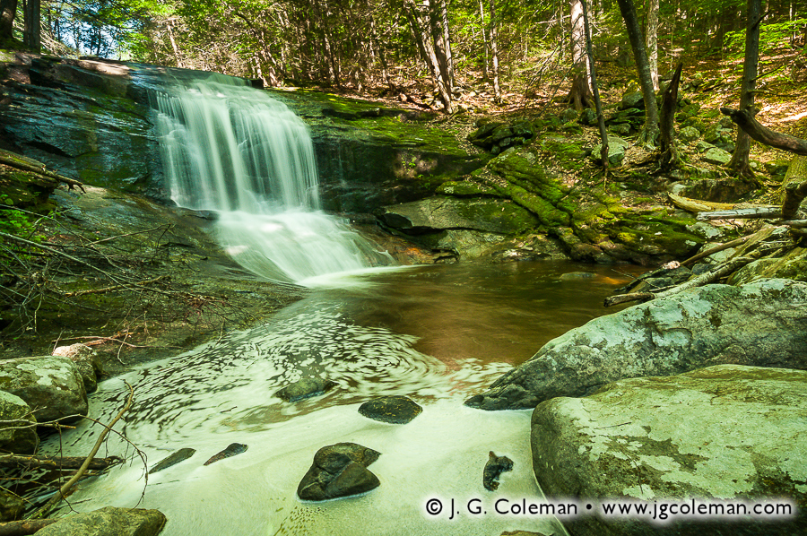
Our journey from the heart of the Berkshires to the borderlands of those famed mountains doesn’t end in Connecticut, though. Instead, we’re going to leave the foot of Great Falls and head northeast about 50 miles, back into the highlands of Massachusetts for a quick stop in the forests of Ashfield. It is here that Chapel Brook meanders through the gently sloping woodlands of Pony Mountain, keeping a mostly calm and reserved demeanor until spilling over a series of abrupt rock ledges to form Chapel Falls. My new piece, “On the Flank of Pony Mountain”, brings us into the Chapel Brook gorge where the waterfall plunges over a rock outcropping into the pool below. Foam churned up by the falls swirls along the periphery of the brook, ever cloaked as it is in the thick shadows of the forest canopy despite the rather sunny, cloudless day overhead.
Chapel Brook Reservation, Ashfield, Massachusetts
© 2013 J. G. Coleman
Protected as part of Chapel Brook Reservation, Chapel Falls lies within Franklin County, some 10 miles east of the Berkshire County line. But even if it doesn’t fall within the political boundaries of Berkshire, Chapel Falls and the vast 40-square-mile expanse of Ashfield are typically described as laying within the eastern foothills of the Berkshires. Of course, merely experiencing the furrowed and densely forested terrain of this region is indication enough that it has inherited more than a bit of the character of the mountainlands to the west.
Until Next Time…
With that, we conclude our Journey Into the Berkshires, even if there’s still plenty more to see in these scenic mountainscapes of Western Massachusetts. Looking back at the three-part series of new prints, though, there’s little doubt that plenty of ground has been covered. We’ve traveled to the northern Berkshires to peer out from the heights of Mount Greylock, marveled at a sun halo from the grounds of Natural Bridge and stood at the foot of Tannery Falls. In the central Berkshires, we delved deep into the legend of Wahconah Falls. Bash Bish Falls and Race Brook Falls were welcome stops in the southern Berkshires. We’ve even managed to push into the neighboring highlands to take in the views at Chapel Brook and headed down the Housatonic River to see the Great Falls in Connecticut’s northwest.
“There is something about the scenery,” wrote Clark Bryan in his 1887 Book of Berkshire,” that imparts a quietude, a repose, a freedom from distraction, a healing with the balm of Dame Nature. The unequaled harmony of the surroundings exhales an influence that enraptures the beholder, and creates within him an inward form of the external.” Bryan’s time has long since past, just as the way of life in the Berkshires has surely changed since he penned those words. But the modern-day visitor to this western mountain spine of New England will discover that these forested mountains are timeless in their allure, possessing a beauty and serenity that has persisted through centuries untold. The pieces I’ve introduced with Journey Into the Berkshires are momentary visions of these enduring wildlands; vignettes of a rugged and subtly sublime landscape that I offer to you with the hopes that they can strike the same chords of awe and appreciation that inspired them.
Want to See More?
- To buy a fine art print of any of the pieces seen above, visit my gallery pages for Mount Everett State Reservation, Great Falls of Canaan and Chapel Brook Reservation.
- If you missed the earlier installments of my three-part Journey Into the Berkshires series, be sure to check out Part 1 and Part 2.