Categories
All Things Connecticut New Print Releases The American Northeast

Eightmile Crossing

Eightmile Crossing (Covered Bridge at Southford Falls State Park, Southbury & Oxford, Connecticut)
“Eightmile Crossing”
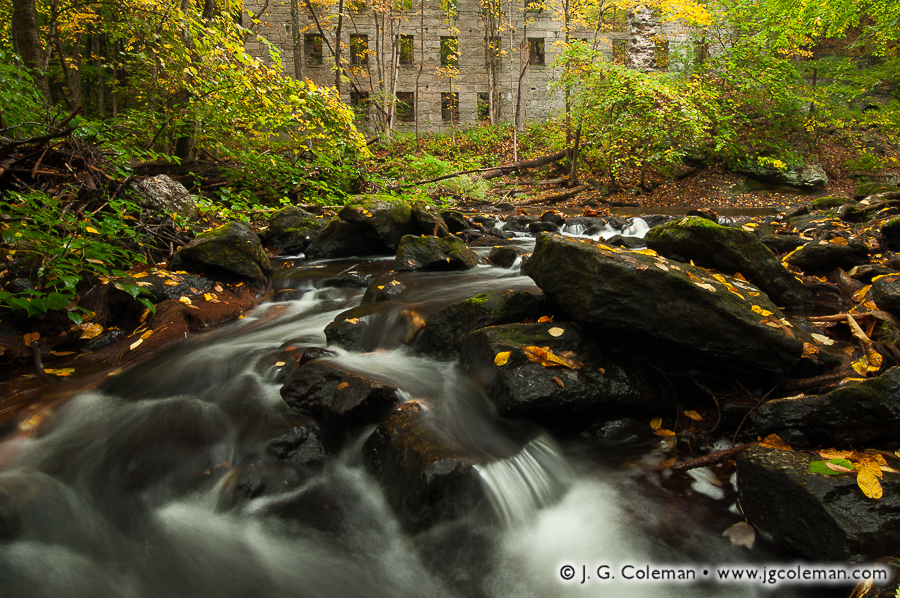
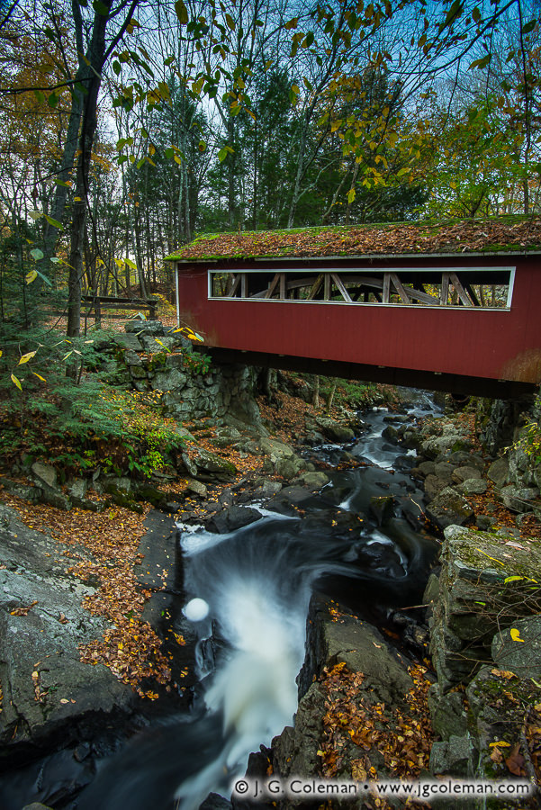
Covered bridge at Southford Falls State Park, Southbury & Oxford, Connecticut

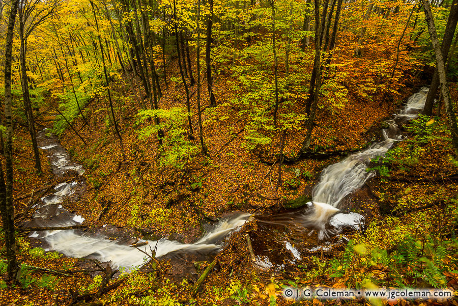
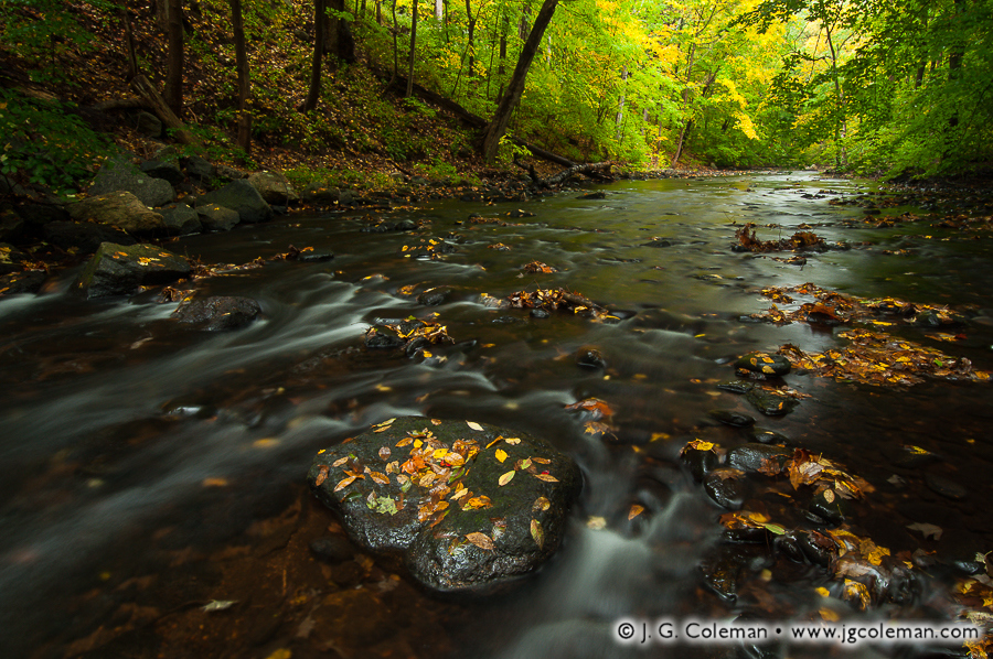
Even as woodlands along Eightmile Brook grow increasingly bare by late October, the river gorge remains lively as ever with exuberant cascades singing away in the shadow of a covered bridge above.

Although dozens of covered bridges could be found throughout Connecticut during the 19th-century, most have long since been lost to floods, fires, wear and tear and changing technology that had rendered the venerable timber bridges largely obsolete more than a century ago. Only three covered bridges built before 1900 are left in Connecticut these days, each of which has become a beloved icon in its host town. But while historical covered bridges may be few and far between in Connecticut, there’s also a handful of covered bridges dotting the state which were built later, from the 1950s and onward.

Unlike their antique forebears, these relatively new covered bridges were never really intended to be trafficked crossings, but rather carefully crafted replicas that recall New England’s early days. Take the covered bridge in “Eightmile Crossing”, for example: although it uses the authentic Burr Arch truss design patented in 1817, it wasn’t actually built over Southford Falls until 1972.

Purchase a Fine Art Print or Inquire About Licensing

Click here to visit my landing page for “Eightmile Crossing” to buy a beautiful fine art print or inquire about licensing this image.

Want to See More?

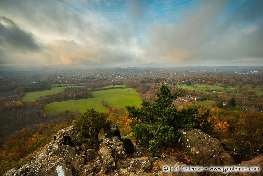
Be sure to check out all of my work from Southford Falls State Park.

Categories
All Things Connecticut New Print Releases The American Northeast

A Golden View of the Silver City

Daybreak at Chauncey Cliffs (Chauncey Peak, Giuffrida Park, Meriden, Connecticut)
“Daybreak at Chauncey Cliffs”
Chauncey Peak at Giuffrida Park, Meriden, Connecticut

Gusting winds rock a cluster of cedars dauntlessly perched atop an ancient traprock cliff in the Metacomet Range. In the valley below, the outskirts of Meriden are eased from their twilight slumber as dawn banishes a blanket of morning fog.

Originally known as Meriden Farm when it was settled by hard-scrabble pioneers from the Connecticut Colony in the mid-1600s, Meriden has managed over the intervening centuries to swell from a remote, agrarian outpost to a city of more than 60,000. Industry flourished there during the Gilded Age and beyond, especially in the form of silver manufacturing, earning Meriden the nickname “Silver City”. The handle persists to this day, even long after the old factories were shuttered.

But if The Silver City isn’t really notable for its silver any longer, it’s certainly a veritable gold mine of municipal parkland. Almost 18% of Meriden’s landscape is contained within city parks and, as the literature explains, “no other city in New England can match that percentage!” Central among those parks are Meriden’s traprock ridges, characterized by precipitous cliffs which tower over the surrounding valleys and dominate the city’s horizon. I produced “Daybreak at Chauncey Cliffs” from the summit of the 700-foot Chauncey Peak which rises from woodlands in the northeastern reaches of the city.

Purchase a Fine Art Print or Inquire About Licensing

Click here to visit my landing page for “Daybreak at Chauncey Cliffs” to buy a beautiful fine art print or inquire about licensing this image.

Want to See More?

Be sure to check out all of my work from the landscapes of Meriden, Connecticut.

Categories
All Things Connecticut New Print Releases The American Northeast

A Serpent Awakened

A Serpent Awakened (Gorge Cascade Falls, Sleeping Giant State Park, Hamden, Connecticut)
“A Serpent Awakened”
Gorge Cascade Falls, Sleeping Giant State Park, Hamden, Connecticut

In the autumn forests of Hamden along the flank of the Sleeping Giant hills, a cascading stream boils fiercely with whitewater as it surges around a bend at the bottom of a leaf-scattered gorge.

When a client asked me last year about Gorge Cascade Falls, a mingling of waterfalls and cascades along a nameless brook at Sleeping Giant State Park, I gave my honest answer: Sleeping Giant is an incredible state park for its extensive trails and mountaintop vistas, but it’s just not a waterfall destination.

I still stand by that assessment, as the stream is starved for water most of the year and the “falls” can nearly dry up during summertime droughts. But in those rare cases when, for example, an October Nor’easter dumps 5 inches of rain in a day, even this little kitten of a waterfall enjoys a few days of roaring like a lion.

Purchase a Fine Art Print or Inquire About Licensing

Click here to visit my landing page for “A Serpent Awakened” to buy a beautiful fine art print or inquire about licensing this image.

Want to See More?

Be sure to check out all of my work from Sleeping Giant State Park.

Categories
All Things Connecticut New Print Releases The American Northeast

Wigwam Blue

Wigwam Blue (Wigwam Reservoir, Thomaston, Connecticut)
“Wigwam Blue”
Wigwam Reservoir, Thomaston, Connecticut

A grove of pines stand shrouded with morning mist on the tranquil shores of Wigwam Reservoir, their towering trunks inverted in a mirror-like reflection upon the still water below.

While the Greater Hartford region and its thirst for water spawned such magnificent creations as the Barkhamsted Reservoir, several other cities elsewhere in Connecticut were similarly tasked around the turn of the 19th century with determining how they would bring sufficient water to their burgeoning populations. Waterbury, for example, is supplied by a system of five generous reservoirs, the first of which was Wigwam Reservoir up north in Thomaston on a tributary of the Naugatuck River.

Construction of Wigwam Reservoir began in 1893 with the clearing of land and preliminary dam work. A pipeline measuring three feet in diameter was routed about 10 miles to Waterbury the next year and, by 1896, water was flowing. It wasn’t until 1901 that the dam was finally built up to its full height, inundating the hundred-acre basin of Wigwam Reservoir with more than 700 million gallons of water.

Purchase a Fine Art Print or Inquire About Licensing

Click here to visit my landing page for “Wigwam Blue” to buy a beautiful fine art print or inquire about licensing this image.

Want to See More?

Be sure to check out all of my work from Thomaston, Connecticut.

Categories
All Things Connecticut New Print Releases The American Northeast

Remembering Alice

Woodland Remembrance (Alice Newton Street Memorial Park, Woodbridge, Connecticut)
“Woodland Remembrance”
Alice Newton Street Memorial Park, Woodbridge, Connecticut

In my newly-released piece, “Woodland Remembrance”, sunlight pierces the forest canopy in the heart of Woodbridge, transforming the understory into a blissfully verdant landscape fit for a fairytale.

Although Connecticut began building its state park system in the mid-1910s and town-owned parks had existed far earlier, nature preserves owned for the public good outside the realm of government were generally a slightly later phenomenon.

The Woodbridge Park Association, operating independently of Woodbridge’s town government, was among the earliest organizations in Connecticut to acquire and manage preserved land on a not-for-profit basis. The Association got its start back in 1928 when it was founded in order to fulfill the vision of philanphropist Newton Street who had decided to forever preserve over 80 acres of land in memory of his mother, Alice Street. The result, featured in this latest piece of mine, was the Alice Newton Street Memorial Park.

Purchase a Fine Art Print or Inquire About Licensing

Click here to visit my landing page for “Woodland Remembrance” to buy a beautiful fine art print or inquire about licensing this image.

Want to See More?

Be sure to check out all of my work from Alice Newton Street Memorial Park.

Categories
All Things Connecticut New Print Releases The American Northeast

Whigville, April’s End

Whigville, April's End (Whigville Falls, Burlington, Connecticut)
“Whigville, April’s End”
Whigville Falls, Burlington, Connecticut
© 2017 J. G. Coleman

It’s waterfall season, folks: that exciting window in the second half of spring after the leaves start emerging but before waterfalls on smaller woodland brooks are rendered as trickles by warm, dry summer weather.

Whigville Falls (above), a little-known cataract in Burlington, hasn’t appeared in my work before; I scouted it out this past winter and had been waiting for just the right conditions before heading back. When a touch of morning mist was forecast a couple days ago, I knew it was time!

Purchase a Fine Art Print or Inquire About Licensing

Click here to visit my landing page for “Whigville, April’s End” to buy a beautiful fine art print or inquire about licensing this image.

Want to See More?

Be sure to check out all of my work from Burlington, Connecticut.

Categories
All Things Connecticut New Print Releases The American Northeast

Nightfall at Hogback Mountain

A Hundred Miles of Nightfall (Old cabin atop Hogback Mountain, Marlboro, Vermont)
“A Hundred Miles of Nightfall”
Old cabin atop Hogback Mountain, Marlboro, Vermont
© 2016 J. G. Coleman

A breath-taking vista, wrought in endless peaks and valleys and lined with wild forests, unfolds before the humble front porch of a rustic, old cabin nestled amidst Vermont’s Green Mountains.

I produced my latest release atop the 2,400-foot Hogback Mountain, a majestic overlook in Southern Vermont fittingly dubbed the “100-Mile View” which peers deeply into the neighboring mountainscapes of Massachusetts and New Hampshire.

Purchase a Fine Art Print or Inquire About Licensing

Click here to visit my landing page for “A Hundred Miles of Nightfall” to buy a beautiful fine art print or inquire about licensing this image.

Want to See More?

Be sure to check out all of the work from Vermont.

Categories
All Things Connecticut New Print Releases The American Northeast

Sylvan Divine

Sylvan Divine (Fieldstone wall in forest during autumn, Litchfield, Connecticut)
“Sylvan Divine”
Fieldstone wall in forest during autumn, Litchfield, Connecticut
© 2015 J. G. Coleman

Parched maple leaves blanket the forest floor, rustling amidst an old fieldstone wall which has been toppled by more than a century of fallen trees and frost-heave. Fiery autumn light erupts through the woodland canopy before us, awakening the landscape to a pleasant warmth that grows ever-scarcer as the season wanes.

Fieldstone walls such as this one generally date back to the 1800s. Tens of thousands of miles of them criss-crossed the landscape in that era as the stony soil of New England farms was laboriously combed free of rocks. But why would a farmer have built a stone wall in the woods, as we see here?

It may be hard to believe, but this stone wall is far older than the surrounding forest. Had we stood in this very spot in the 1860s, for instance, we probably would’ve looked beyond this wall to see open pastureland stretching to the horizon. The woods that we see now wouldn’t even have sprouted until decades later as agriculture declined and expansive farmlands were abandoned to the hand of nature. These days, Connecticut is host to roughly 3,000 square miles of forest which feels as old as time itself, yet most of it began growing on deserted farmland little more than 150 years ago.

Purchase a Fine Art Print or Inquire About Licensing

Contact J. G. Coleman to buy a beautiful fine art print of “Sylvan Divine” or inquire about licensing this image.

Want to See More?

Be sure to check out more of my work from Litchfield, Connecticut in places like Humaston Brook State Park and the nature preserve at White Memorial Conservation Center.

Categories
New Print Releases The American Northeast

Deadwood at Goldmine Brook Falls

Deadwood at Goldmine (Goldmine Brook Falls, Chester, Massachusetts)
“Deadwood at Goldmine”
Goldmine Brook Falls at Chester-Blandford State Forest, Chester, Massachusetts
© 2015 J. G. Coleman

Bark peels from the trunk of a fallen birch wedged into the boulders of a gorge in Western Massachusetts. Just ahead, Goldmine Brook Falls descends 40 feet into the ravine amidst ancient, weathered rock faces softened by jackets of moss.

Drive through the quiet, wooded town of Chester, Massachusetts where I produced “Deadwood at Goldmine” (at top) and it might seem hard to believe that area was historically bustling with mines of all sorts. First came the early iron mines; later, in the mid-1800s, a somewhat rare, abrasive mineral known as emery became the object of commercial efforts. Yet the name “Goldmine Brook” is still a bit puzzling, since there doesn’t seem to be any record of sincere attempts at mining the precious metal at any point in Chester’s past.

While there is undoubtedly gold in the valleys of Western Massachusetts, it’s been scattered too broadly and too thinly upon the landscape by the prehistoric advance and retreat of glaciers. Suffice it to say, the amount of gold you might get after a day of panning a creek in Southern New England wouldn’t even cover the cost of driving home.

Purchase a Fine Art Print or Inquire About Licensing

Click here to visit my landing page for “Deadwood at Goldmine” to buy a beautiful fine art print or inquire about licensing this image.

Want to See More?

Be sure to check out all of my work from Chester-Blandford State Forest.

Categories
All Things Connecticut New Print Releases The American Northeast

Fields of Kale at West Granby

Yankee Farmlands № 32 (Farm field with kale, Granby, Connecticut)
“Yankee Farmlands № 32”
Field of kale, Granby, Connecticut
© 2015 J. G. Coleman

In the latest addition to my Yankee Farmlands project, wrinkled plumes of kale climb over encroaching weeds on a swath of sunny cropland in the hills of West Granby. Warm, summertime air drifts lazily through the field, the breeze too faint to stir the still forests along the farm edge.

Vegetables such as kale, collards, cabbage, broccoli, cauliflower, kohlrabi and brussel sprouts are popular greens that occasionally even share the same field. But would you believe that every one of those vegetables represents the same species? That’s right… even though they may look dramatically different, they all possess genes which are virtually identical to those of a weed known as “wild lettuce”.

How was such a diverse array of vegetables derived from a single species? Thousands of years ago, early farmers carefully selected generation after generation of cultivated wild lettuce to promote certain desired traits: long stems for kohlrabi, enlarged flower buds for broccoli, broad leaves for kale and so on.

Purchase a Fine Art Print or Inquire About Licensing

Click here to visit my landing page for “Yankee Farmlands № 32” to buy a beautiful fine art print or inquire about licensing this image.

Want to See More?

Be sure to check out all of my work in my ever-growing Yankee Farmlands project, a series which celebrates the agricultural heritage of Southern New England through the beautiful farmlands of Connecticut.

Categories
All Things Connecticut New Print Releases The American Northeast

Okumsett Fringe

Okumsett Fringe (Glen Falls near Okumsett Preserve, Portland, Connecticut)
“Okumsett Fringe”
Glen Falls near Okumsett Preserve, Portland, Connecticut
© 2015 J. G. Coleman

In my new release, “Okumsett Preserve”, Glen Falls glows with whitewater as it careens over a sheer, 20-foot ledge, plunging Cobalt Stream into a shallow, woodland oasis lined by mossy cliffs, gravel beds and swaying ferns.

As early as the mid-1600s, the lands surrounding the mile-long Cobalt Stream were firmly believed to be rich in various ores and precious metals. Connecticut’s first governor, John Winthrop, laid claim to some 800 acres in the area and legends tell of him camping out in the hills, assiduously mining gold and casting rings that he would carry back to his home in New London. The territory consequently received the nickname, “The Governor’s Ring”.

Generation after generation of enterprising men made countless attempts to mine the Governor’s Ring for about 200 years. Some sought gold and silver, while others set their sights toward cobalt and lead. Except for occasional veins of cobalt, most of these operations proved fruitless. By 1844, a Connecticut geology professor finally summed up two centuries of unproductive mining around Cobalt Stream: “it is a curious fact, that after all that has been done in this mine, very little is really known to the public as to the worth of the minerals located there, and whether it could be worked to any profit.”

Purchase a Fine Art Print or Inquire About Licensing

Click here to visit my landing page for “Okumsett Fringe” to buy a beautiful fine art print or inquire about licensing this image.

Want to See More?

Be sure to check out all of my work from Glen Falls and Okumsett Preserve.

Categories
All Things Connecticut New Print Releases The American Northeast

The Old Days at Cotton Hollow

Cotton Hollow Echoes (Roaring Brook at Cotton Hollow Preserve, Glastonbury, Connecticut)
“Cotton Hollow Echoes”
Roaring Brook at Cotton Hollow Preserve, Glastonbury, Connecticut
© 2015 J. G. Coleman

“Cotton Hollow Echoes”, one of my new pieces released this week, brings us to the shady depths of Glastonbury’s Cotton Hollow, where spirited cascades along Roaring Brook serenade the haunting, overgrown edifice of a long-abandoned mill.

There was a time when this stretch of Roaring Brook was the epicenter of South Glastonbury’s industrial might. From the 1700s onward, the river was lined with mills and factories that dammed the river, harnessing its strength to animate machinery. Cotton Hollow saw the production of everything from gun powder to boat anchors to its eponymous cotton textiles.

The Brook Remembers (Roaring Brook at Cotton Hollow Preserve, Glastonbury, Connecticut)
“The Brook Remembers”
Roaring Brook at Cotton Hollow Preserve, Glastonbury, Connecticut
© 2015 J. G. Coleman

But times change; so does technology. Once modern electrical grids eliminated the need for industry to be tethered to rivers, the crowded mills along Roaring Brook were slowly silenced. Boulder dams were eventually toppled. Woodlands eagerly reclaimed the river. Today, a quiet nature preserve occupies the very riverbanks where throngs of mill workers once labored amidst a cacophony of frantic machinery.

Purchase a Fine Art Print or Inquire About Licensing

Click here to visit my landing page for “Cotton Hollow Echoes” or “The Brook Remembers” to buy a beautiful fine art print or inquire about licensing this image.

Want to See More?

Be sure to check out all of my work from Roaring Brook and the forests of Cotton Hollow.