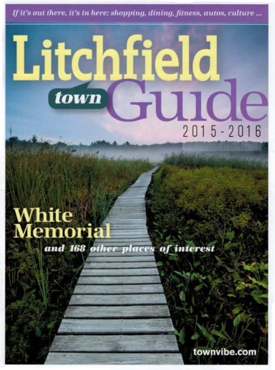
It’s particularly gratifying whenever I see my photography put to use in a publication, even more so when its placement is prominent. This year’s Litchfield Town Guide does just that, filling its cover with one of my pieces from the wildlands of Litchfield, Connecticut.
When I produced my piece, “Ethereal Passage”, in mid-August of 2012 on the boardwalks around Little Pond at the White Memorial Foundation, its cover-worthiness was the last thing on my mind. My only interest in that moment before dawn, as I stood beneath a sky painted with wisps of faintly luminous clouds, was to capture the weather-beaten boardwalk as it meandered its way through shadowy wetlands towards a whimsical vanishing point in the misty, silhouetted forest on the horizon. The shot came together exactly as I had envisioned.
And, as it would happen, “Ethereal Passage” was precisely what Litchfield Magazine had in mind when it began looking for a cover photograph for its 2015 town guide. As a directory of places-to-go and things-to-do in the lovely town of Litchfield, it’s only fitting that the sprawling, 4,000-acre nature preserve in town operated by the White Memorial Foundation would be the first thing readers see!
Purchase a Fine Art Print or Inquire About Licensing
Connecticut’s Northwest Hills, encompassing roughly 1,000 square miles and 20 municipalities, are oftentimes thought of as the “the backcountry” of the Nutmeg State. These highlands are largely a rough and mountainous terrain, deeply-furrowed with valleys and river gorges that cut between several of the highest summits in the state. Conspicuously avoided by Connecticut’s major highways, the region is largely traversed by winding, woodland backroads. It is perennially colder here than the rest of the state, usually receiving the most snow and being the last area of Connecticut to see that snow melt away in the Spring. The population density is unusually low at only about 140 people per square mile, fully five times more sparse than that of Connecticut as a whole.
Even if Connecticut’s “frontier days” came and went centuries ago, the Northwest Hills are nonetheless host to lost vestiges of that bygone era; places that feel as if they were somehow left behind as time pushed forward. My latest work from this corner of the state illustrates just a couple of the enchanting landscapes that draw me back time and time again whenever I am moved to head northwest, out of the population centers of the Connecticut River Valley and into these rural wilds.
White Memorial Conservation Center Litchfield, Connecticut
In my piece, “Ethereal Passage”, a seemingly endless boardwalk invites us to wander into a twilight dreamscape of lush wetland foliage. As we follow the dimly-lit pathway, we all but lose ourselves in mist-laden forest silhouettes beneath a sky painted with delicate wisps of clouds that foreshadow the approaching dawn.
Despite the surreality of “Ethereal Passage”, it portrays a place which is very real, indeed. These wetlands lie on the fringes of Little Pond, a small body of water within the vast 4,000-acre White Memorial Conservation Center in Litchfield, Connecticut. Encompassing more land than even the largest of Connecticut’s state parks, the White Memorial Conservation Center is a most impressive effort in the preservation and management of the wilds of the Northwest Hills. A varied array of plant and animal life flourish within the Center’s six square miles of forest, rivers and ponds, open fields, wet meadows, swamps and vernal pools.
The origins of the White Memorial Conservation Center revolve around Alain White, a wealthy man whose dedication to preserving natural places began in the early 1900s and ultimately saw him becoming one of the most influential figures ever to exist in the history of Connecticut conservation efforts. The story begins at the banks of Bantam Lake in Litchfield in 1908, where Alain is said to have had something of an epiphany while fishing with a good friend amidst the quiet countryside. As if all of the sudden realizing his life’s mission, he commented that it would be grand if the landscape could remain in its peaceful and largely-undeveloped condition well into the future.
In that day in age, the idea of setting aside land to be protected from development was still relatively new; many industrious Americans insisted that the practice was as preposterous as it was wasteful. And, if he was so inclined, Alain could’ve simply shrugged off his passing idea, finished his day of fishing, and gone about his life no different than before. But, as unlikely as it may seem, that fleeting thought seized upon his consciousness and blossomed into a far-reaching campaign of preservation. In total, Alain and his White Memorial Foundation contributed nearly 6,000 acres of open space to the State of Connecticut, mostly for inclusion in state parks and state forests throughout Connecticut’s Northwest Hills.
Roughly 4,000 additional acres of land, comprising the White Memorial Conservation Center in Litchfield, now surround Bantam Lake… the very place where, little more than a century ago, Alain White sat patiently with his fishing rod waiting for a bite, entertaining the lofty idea that there was something inherently important in ensuring that future generations could find peace in places of nature. Certainly, he drew from the same deep intuition as the great John Muir, who wrote that “everybody needs beauty as well as bread, places to play in and pray in, where nature may heal and give strength to body and soul.”
And with that, I introduce to you another of my new works from the White Memorial Conservation Center: “Bantam River Quietude”. In this work, we overlook the calm waters of the Bantam River as they depart from Little Pond on their way towards nearby Bantam Lake. Mirror-smooth water reflects the soft colors from above so strongly that it is almost as if the Bantam River is fed by the sky itself. Only the wetlands, alive with pickerelweed and grasses and softened by a lingering mist, frame the the scene and provide orientation.
“Bantam River Quietude” is an expression of simplicity and serenity; an attempt to access that state of peaceful contemplation that Alain White found on that fateful day beside Bantam Lake.
Housatonic River Kent, Connecticut
Our next stop in the Northwest Hills brings us to the banks of the scenic Housatonic River, specifically that stretch which cuts through the old Bulls Bridge section of Kent. In 1897, Francis Atwater wrote in his book, History of Kent, Connecticut, that “the lover of the beautiful can see something fortunate in the circumstances which protected Bulls Bridge from the roar of the great world and left it sequestered and almost as picturesque as in its pristine days before the white man came and made his wide clearings.” According to Atwater, the railroad never quite made its way to Bulls Bridge. So, while so many previously small towns in Connecticut began to blossom into small cities with the advent of the rail in the mid-1800s, Bulls Bridge seemed to have been left behind.
Although Atwater wrote those words over a century ago, little has changed in the interim. Even as the importance of the railroads began to atrophy with the popularity of personal automobiles, Kent has continued to remain mostly rural and sparsely-populated. And, indeed, we can still see “something fortunate” in the sheer breadth of natural beauty that has been spared within Kent.
Take my new piece, “Housatonic Summer”, for instance. Here we are treated to a view of the boulder-laden Housatonic River as it furiously cascades southwards on its journey towards Long Island Sound, still some 40 miles away. The dense forest which crowds the riverbanks glows with vitality in the potent sunlight of late-morning. High above, the airy clouds against a bold blue sky top it all off. “Housatonic Summer” is more than just a journey into this riverscape of the Northwest Hills: it is a celebration of those perfect summer days that we’ve all come to love, no matter where we may live.
But this particular stretch of the Housatonic is rather unique for a few reasons. Only a few hundred feet downstream from this vista is Bulls Bridge, one of Connecticut’s only two remaining covered bridges that are still used by traffic. One might guess that the old village of Bulls Bridge was named after this bridge, but the exact opposite is the case. For roughly 250 years, the Bulls Bridge area of Kent was simply a well-known locale where the Housatonic River could be crossed. There were at least a few different bridges built there, beginning with one purportedly constructed by the Bull family, which ran an ironworks closeby in the mid-1700s. The wooden bridges of those early days didn’t have nearly the longevity of modern bridges, so as one wore out another would be built. It’s not clear exactly how many different bridges spanned the Housatonic in Bulls Bridge over the centuries, but the current version was not constructed until the mid-1800s. Spanning a distance of more than 100′ across the river, the bridge eventually received modern metal underpinnings which have strengthened it enough to allow a single lane of traffic to pass through on a daily basis.
Perhaps even more impressive are the gaping, smooth-bored holes in the limestone outcroppings that flank the western side of the river beneath the bridge and extend about 300 feet upstream. Known as “giant’s kettles” or “giant’s cauldrons” (or occasionally just termed “potholes”), these deep pits are the result of abrasive detritus like sand and stones getting caught in depressions in the bedrock floor of the river. As eddies in the water swirl them around and around, they gradually grind more deeply into the depression. Over the course of hundreds or thousands of years, this gradual grinding action can carve some surprisingly deep pits in solid stone.
One of these cauldrons is prominently featured in my new piece, “Giant’s Kettle on the Housatonic”. Producing this photograph required a good deal of planning and patience in order to fulfill my vision for the the shot. While I knew that I wanted to highlight one of these remarkable limestone rock formations, I needed to find a perspective from which I could capture all the elements that come together to make this stretch of the Housatonic such a captivating place. After scrambling some distance upon the pock-marked riverside bedrock, I came to the kettle you see here, which seemed to offer the opportunity I’d been seeking. Something as simple as setting up the tripod was quite challenging, since the only surface available was deeply-pitted limestone. Even once I managed to haphazardly brace the tripod legs, I had to wait over an hour for the perfect lighting conditions: bright enough to illuminate the vicious currents of the Housatonic that carved these kettles, but also subtle enough that I could simultaneously capture detail within the smooth, shadowy kettle in the foreground, where foamy water still endlessly swirls away, grinding an ever-deepening cauldron in the stone. All of the time and effort certainly paid off though, for in creating “Giant’s Kettle on the Housantonic”, I was able to swallow up the full magnificence of this grand riverscape.
Want to See More of Connecticut’s Northwest Hills?
There’s little doubt that the Northwest Hills of Connecticut figure quite prominently in my work; acre for acre, I find them to be some of the most wild and picturesque places in the state. Several of the most stunning landscapes in this region are featured in my artwork, so I’ve listed some collections below that will bring you ever deeper into this magical corner of Connecticut. Also, be sure to check out two of my previous posts —”Rivers & Streams Emerging from Winter” and “Car Troubles on the Way to Kent“— both of which discuss Kent Falls (located in Kent, only about 10 miles northeast of Bulls Bridge).
Kent Falls is probably Connecticut’s most well-known and scenic set of waterfalls. I’ve spent more time here than almost any other individual park in the Northwest Hills, capturing views of the remarkable limestone cascades and the wonderful transformations that occur with each season.
Located mostly in Norfolk, this is the only Connecticut state park which is not entirely located within the state’s borders. The northern tip of the park juts into Massachusetts, which jointly owns and maintains the park.
Encompassing some of Connecticut’s oldest hemlock and white pines, the old-growth forest of Cathedral Pines Preserve in Cornwall has recently been dubbed a National Natural Landmark by the federal government.
These three nature preserves, all located within Washington, Connecticut and owned by the Steep Rock Association, are amongst some of the most beautiful open spaces in the state.
Located in the rough woodlands of Roxbury, Connecticut, Mine Hill was once the site of a 19th-century ironworks, not unlike those that operated all over the Northwest Hills in those days. The roasting ovens and iron furnace still stand eerily amidst the forest, even though the area is now a scenic nature preserve.