Categories
All Things Connecticut New Print Releases The American Northeast

Seeking Bunnell’s Falls

Old Hotchkiss Riverscape (Upper Burlington Falls, Burlington, Connecticut)
“Old Hotchkiss Riverscape”
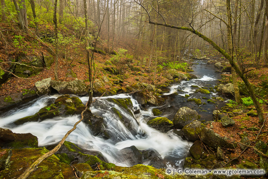
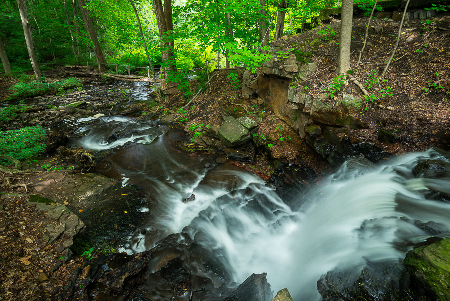
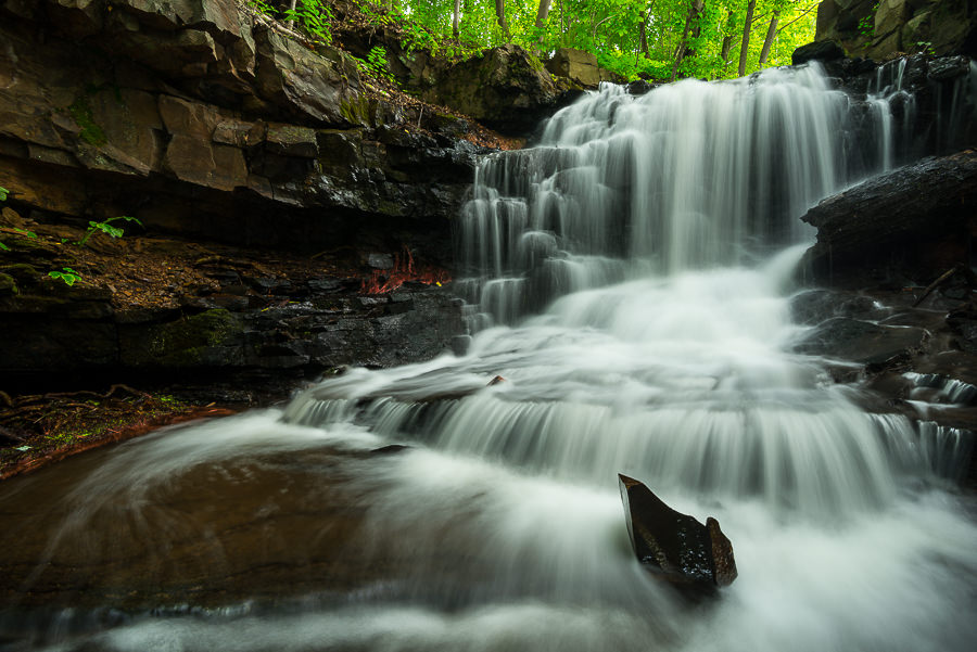
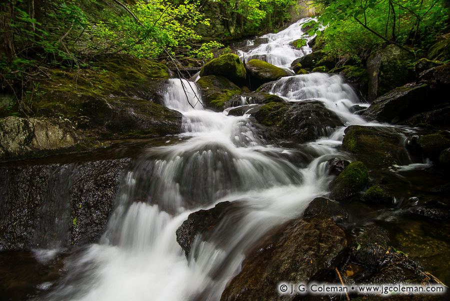
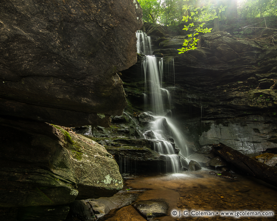
Upper Burlington Falls on Bunnell Brook, Burlington, Connecticut

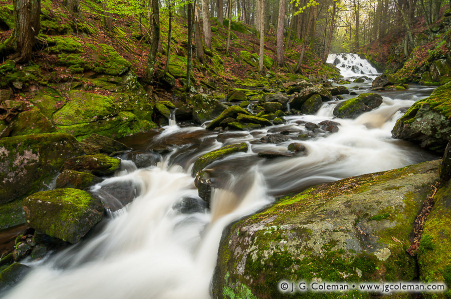
Bunnell Brook crashes over a waterfall in the distance, roiling itself into a whitewater frenzy and charging forth through the verdant woodlands in the hills of Burlington.

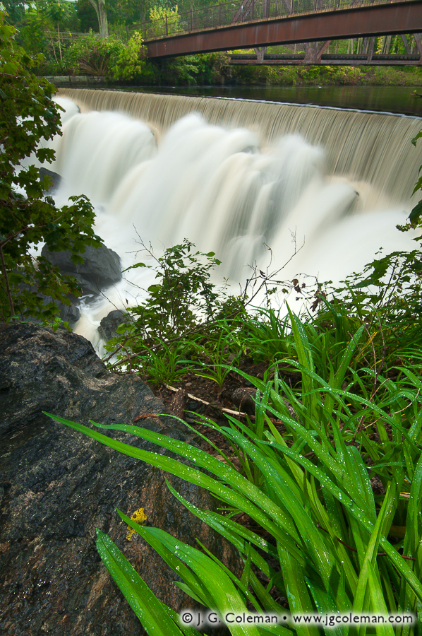
Many of Connecticut’s waterfalls were named long ago when they were at the heart of streamside mills driven by waterwheels or turbines. Some folks may have appreciated the natural beauty back then, but most probably knew them as busy places of industry where goods were churned out and livings were made. And in some cases, once those mills vanished and the waterfalls ceased to be places where livelihoods were earned, the names and stories behind each could become quite jumbled and obscure in just a generation or two.

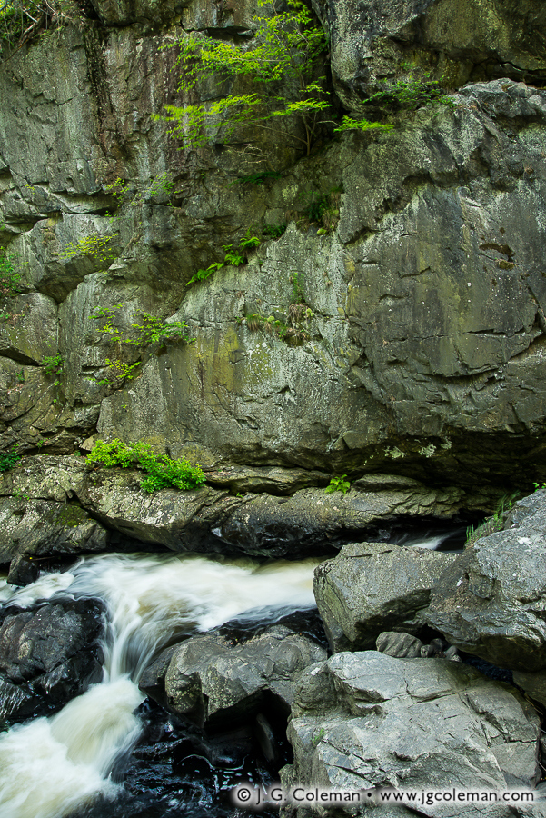
Take the case of Bunnell Brook in Burlington, where there are two distinct waterfalls found about 600 feet apart. We know that one of the two waterfalls was historically called “Bunnell’s Falls”, but which one? An 1895 publication suggests it was the lower falls, though more recent publications tend to apply that name to the upper falls (which are seen in this piece). I don’t know who’s right, but in the meantime, I’ll just stick to Upper and Lower Burlington Falls.

Purchase a Fine Art Print or Inquire About Licensing

Click here to visit my landing page for “Old Hotchkiss Riverscape” to buy a beautiful fine art print or inquire about licensing this image.

Want to See More?

Be sure to check out all of my work from Burlington, Connecticut.

Categories
All Things Connecticut Featured New Print Releases The American Northeast

Southford Falls, Autumn Morning

An Eightmile Rhapsody (Southford Falls State Park, Southbury, Connecticut)
“An Eightmile Rhapsody”
Eightmile Brook at Southford Falls State Park, Southbury, Connecticut

Cold shadows and the warmth of dawn coalesce at Southford Falls, where Eightmile Brook leaps from an old mill pond and stages a vigorous charge through the dark gorge below.

Although I produced this image back in late October of 2017, just as autumn colors were reaching their modest peak last year, it wasn’t until yesterday evening that I managed to process all of my work from that shoot. That’s pretty typical of my autumn imagery each year, the bulk of which tends to be processed only after colder weather takes hold. Why such a long turnaround? Well, the colorful stretch of autumn that we all hold dear generally spans just 5 or 6 weeks; it’s gone just as fast as it arrives, so I need to work quickly. That leaves scant time for sitting in front of a computer tweaking development controls.

I generally dedicate my time during autumn almost exclusively to field work right up until “stick season” sets in. Not familiar with “stick season”? It’s basically the second half of autumn -after the trees have lost their leaves but before winter snows have arrived- when the entire landscape looks like a mess of bare sticks reaching into the sky.

Purchase a Fine Art Print or Inquire About Licensing

Click here to visit my landing page for “An Eightmile Rhapsody” to buy a beautiful fine art print or inquire about licensing this image.

Want to See More?

Be sure to check out all of my work from Southbury, Connecticut.

Categories
All Things Connecticut New Print Releases The American Northeast

The Clarks and The Creek

Clark Creek flits about in riffles and cascades as it snakes through old Tylerville en route to the Connecticut River. Springtime woodlands immerse the falls in shadow as soothing murmurs of tumbling water rise into the canopy.

Clark's Stairway (Clark Creek Falls on Clark Creek, Haddam, Connecticut)
“Clark’s Stairway”
Clark Creek Falls on Clark Creek, Haddam, Connecticut
© 2016 J. G. Coleman

Sometimes a simple babbling brook can, through tangential association, lead us unexpectedly into topics of great historical importance. For example, one historian recalled in 1900 that “the Clarks of… Clark’s Creek in Tylverville are descended from Major John Clark… who is named as one of the patentees in the Charter of Charles II to Connecticut in 1662.” Sure, at face value that may seem to be an obscure reference, but it’s difficult to overstate the importance of that founding document to which the name of Clark Creek can be circuitously traced.

Tylerville Cascades (Clark Creek Falls on Clark Creek, Haddam, Connecticut)
“Tylerville Cascades”
Clark Creek Falls on Clark Creek, Haddam, Connecticut
© 2016 J. G. Coleman

The Charter of 1662 gave legal blessing to the Connecticut Colony in the eyes of the English monarchy, ensuring an impressive measure of self-governance for what had previously amounted to little more than a loosely-associated series of Puritan settlements south of Massachusetts. Upon granting that early charter, it’s likely that Charles II couldn’t have imagined that Connecticut and its sibling colonies would be back just about a century later, demanding a far greater degree of self-governance that would change everything.

Purchase a Fine Art Print or Inquire About Licensing

Click here to visit my landing page for “Clark’s Stairway” or “Tylerville Cascades” to buy a beautiful fine art print or inquire about licensing either of these images.

Want to See More?

Be sure to check out all of my work from Clark Creek Falls.

Categories
All Things Connecticut New Print Releases The American Northeast

Whigville, April’s End

Whigville, April's End (Whigville Falls, Burlington, Connecticut)
“Whigville, April’s End”
Whigville Falls, Burlington, Connecticut
© 2017 J. G. Coleman

It’s waterfall season, folks: that exciting window in the second half of spring after the leaves start emerging but before waterfalls on smaller woodland brooks are rendered as trickles by warm, dry summer weather.

Whigville Falls (above), a little-known cataract in Burlington, hasn’t appeared in my work before; I scouted it out this past winter and had been waiting for just the right conditions before heading back. When a touch of morning mist was forecast a couple days ago, I knew it was time!

Purchase a Fine Art Print or Inquire About Licensing

Click here to visit my landing page for “Whigville, April’s End” to buy a beautiful fine art print or inquire about licensing this image.

Want to See More?

Be sure to check out all of my work from Burlington, Connecticut.

Categories
All Things Connecticut New Print Releases The American Northeast

Bulkeley’s Millstream

Bulkeley's Millstream (Upper Dividend Falls on Dividend Brook, Dividend Pond Park & Archaeological Site, Rocky Hill, Connecticut)
“Bulkeley’s Millstream”
Upper Dividend Falls on Dividend Brook, Dividend Pond Park & Archaeological Site, Rocky Hill, Connecticut
© 2016 J. G. Coleman

In a shady gorge beneath the dense canopy of summertime woodlands, Dividend Brook leaps eagerly from a jagged cliff before meandering a half-mile eastward to unite with the vast Connecticut River.

Although industry has largely been divorced from a need for water power in modern times, there are few natural waterfalls in Connecticut that didn’t serve as mill sites at some point over the past four centuries. In many cases, these waterfalls drove streamside manufactories for several generations and churned out everything from flour to hand tools as the economy shifted and society’s needs changed. The falls on Dividend Brook are a perfect example, having been granted to Reverend Gershom Bulkeley for a grist mill back in 1665, only about 20 years after colonists settled in the Connecticut River Valley.

Dividend Downrush (Upper Dividend Falls on Dividend Brook, Dividend Pond Park & Archaeological Site, Rocky Hill, Connecticut)
“Dividend Downrush”
Upper Dividend Falls on Dividend Brook, Dividend Pond Park & Archaeological Site, Rocky Hill, Connecticut
© 2016 J. G. Coleman

The Reverend and his descendants operated mills at Dividend Brook for nearly 150 years, mostly churning out flour from the grain crops of community farmers. By 1830, when the millstream left the family’s hands, a new breed of industrialized millworkers were only just getting started. Axes, chisels, saws, horseshoes, flour, lumber, shears, firearms and bulk iron were produced along the stream during the remainder of the 19th century.

Purchase a Fine Art Print or Inquire About Licensing

Click here to visit my landing page for “Bulkeley’s Millstream” to buy a beautiful fine art print or inquire about licensing this image.

Want to See More?

Be sure to check out all of my work from Dividend Pond Park & Archaeological Site.

Categories
All Things Connecticut New Print Releases The American Northeast

Ceaseless Waterfalls

Graham's Secret (Carr Brook Falls, Portland, Connecticut)
“Graham’s Secret”
Carr Brook Falls, Portland, Connecticut
© 2016 J. G. Coleman

In “Graham’s Secret” (above), the latest installment in my Waterfalls of Connecticut project, the cool waters of Carr Brook slip over a forest-shaded cliff, descending into a ceaseless whirlpool at the bottom of a rugged ravine just a few miles east of the Connecticut River.

When I set about my “Connecticut Waterfalls” project back around 2010, eager to interpret the beauty of the Nutmeg State’s varied natural waterfalls, I’m not sure that I was thinking about how long it might take to see the endeavor through to its conclusion. And so here I am, after more than six years of work, and I’m still expanding the formal collection a couple times each year with imagery from new waterfalls.

Flume at Collins Hill (Carr Brook Falls, Portland, Connecticut)
“Flume at Collins Hill”
Carr Brook Falls, Portland, Connecticut
© 2016 J. G. Coleman

Of course, the core of the project came together a couple years ago in the form a dedicated website, “Waterfalls of Connecticut”, which I invite you to visit. But even as I was busy pulling together the body of work that would premier in the collection, an effort which might customarily mark the end of a thematic project, I knew that waterfalls had earned an enduring place in my subject matter for years to come. I also knew that there was, and still remains, a great many stories of cascading water left to tell in the wilds of Connecticut.

Purchase a Fine Art Print or Inquire About Licensing

Click here to visit my landing page for “Graham’s Secret” to buy a beautiful fine art print or inquire about licensing this image.

Want to See More?

Be sure to check out all of my work from Carr Brook Falls.

Categories
New Print Releases The American Northeast

Coburn Hideaway

Coburn Hideaway (Unnamed waterfall in Westfield, Vermont)
“Coburn Hideaway”
Unnamed waterfall, Westfield, Vermont
© 2016 J. G. Coleman

In my new release, “Coburn Hideaway”, dense forest underbrush embraces a vigorous brook which tosses about in a frenzy as it cascades through a gully of glistening boulders. Mosses spread in vibrant blankets amidst the waterfalls, undeterred by the swift current and furious plunges.

When a few friends and I came upon this brook snaking beneath a small bridge in the wilds of Vermont’s Northeast Kingdom, the tell-tale sound of cascading water could be heard echoing up from the forest understory downstream. I couldn’t resist making a descent into the gorge to investigate the waterfall, lugging everything from my camera bag and tripod to my fishing rod and waders.

Without even the faintest trail to follow, the bushwhack down to the base of the falls was grueling. But the absence of a footpath, as well as the overall remoteness of the place, makes it likely that I’ve been the only person in many decades to peer up from the foot of these cascades. That’s worth every scraped elbow and labored breath!

Purchase a Fine Art Print or Inquire About Licensing

Click here to visit my landing page for “Coburn Hideaway” to buy a beautiful fine art print or inquire about licensing this image.

Want to See More?

Be sure to check out all of my work from Vermont.

Categories
All Things Connecticut New Print Releases The American Northeast

Carr Brook Emerging

Carr Brook Emerging (The Cascade, Meshomasic State Forest, Portland, Connecticut)
“Carr Brook Emerging”
The Cascade, Meshomasic State Forest, Portland, Connecticut
© 2016 J. G. Coleman

Remote woodlands of Central Connecticut emerge from the grip of winter, channeling fresh spring rains through a sprightly brook which tumbles through the hills. The forest floor is obscured beneath a dense blanket of leaf litter, remnants of last autumn that have only recently thawed after several frigid months bound up in ice and buried by snow.

Depending on whose metric we use, there are anywhere from a dozen to as many as a hundred waterfalls in Connecticut. But because so much of the state is criss-crossed by roads, most of them are can be seen with a fairly short walk from the blacktop. Some are even visible without leaving the roadside.

“The Cascade”, a 15-foot horsetail on Carr Brook, is among the few that aren’t quite so easy to reach. This waterfall demands a ¾-mile drive down an old dirt logging road, then a mile long hike through the hills.

Purchase a Fine Art Print or Inquire About Licensing

Click here to visit my landing page for “Carr Brook Emerging” to buy a beautiful fine art print or inquire about licensing this image.

Want to See More?

Be sure to check out all of my work from Connecticut.

Categories
All Things Connecticut New Print Releases The American Northeast

Pequabuck Cauldron

Pequabuck Cauldron, Autumn (Pequabuck Falls on the Pequabuck River, Plymouth, Connecticut)

In my new piece “Pequabuck Cauldron, Autumn”, serene autumn woodlands crowd the Pequabuck River as it leaps over a relict dam which blushes with the magical glow of dawn. Perpetually in a state of discord, the cool waters are forever parting ways for delicate, orderly veils or furious, crashing whitewater.

Although Pequabuck Falls emerged as a purely natural waterfall after the withdrawal of ancient glaciers from Connecticut, a crescent-shaped dam constructed in 1851 dramatically altered their appearance. What we find here today is a “composite waterfall”, one which incorporates rocky tumbles from the original waterfall with orderly cascades over 160-year-old masonry.

Old Photograph of Pequabuck Falls
Pequabuck Falls is seen here in an old photograph dating back to sometime between 1890 and 1930. Although the old pony-truss bridge has long since been replaced, the falls themselves have actually changed very little despite the passage of a century.
© Archives & Special Collections at the Thomas J. Dodd Research Center,
University of Connecticut Libraries

Marvelously varied industries have harnessed water from Pequabuck Falls since the dam was constructed in the mid-19th century. Initially operating a clock factory, the falls later drove machinery which manufactured buckles for the uniforms of Union soldiers during the Civil War. For decades after the conflict, the site continued to turn out everything from mail bags to lumber to tool handles as enterprises came and went. It wasn’t until 1913 that the trusty waterwheel at Pequabuck Falls was finally retired.

Purchase a Fine Art Print or Inquire About Licensing

Click here to visit my landing page for “Pequabuck Cauldron, Autumn” to buy a beautiful fine art print or inquire about licensing this image.

Want to See More?

Be sure to check out all of my work from Pequabuck Falls.

Categories
All Things Connecticut New Print Releases The American Northeast

Northfield December

Northfield December (Knife Shop Falls, Litchfield, Connecticut)
“Northfield December”
Knife Shop Falls, Litchfield, Connecticut
© 2015 J. G. Coleman

Frigid waters leap eagerly over the precipice of Knife Shop Falls amidst an otherwise quiescent, snow-laden forest in the Litchfield Hills.

This forgotten gorge in the sleepy, old village of Northfield was once the site of a prominent knife factory which arose in the 19th-century, its machinery driven by the falling waters of this very brook. After opening in the 1850s, the aptly-named Northfield Knife Company gained worldwide renown for its superlative cutlery in just a few decades. But in spite of this promising reputation, changing times saw the factory shuttered in the 1920s and quiet woodlands eventually reclaimed the ravine.

On an unrelated note, I produced this particular piece in mid-December last year. While it seems that we’ve mostly dodged any significant snowfall this December, I’ve no doubt that 2016 will pull a few punches right out of the gate.

Purchase a Fine Art Print or Inquire About Licensing

Click here to visit my landing page for “Northfield December” to buy a beautiful fine art print or inquire about licensing this image.

Want to See More?

Be sure to check out all of my work from Knife Shops Falls and Humaston Brook State Park.

Categories
All Things Connecticut New Print Releases The American Northeast

Demise at Indian Leap

Falls of Norwich (Yantic Falls, Yantic River Historic District, Norwich, Connecticut)
“Falls of Norwich”
Yantic Falls, Yantic River Historic District, Norwich, Connecticut
© 2015 J. G. Coleman

Swollen with autumn rainfall, the Yantic River slips beneath century-old bridges in the historic district of Norwich before careening furiously over a broad, 140-foot-wide shelf of jagged rock (see “Falls of Norwich” above). A peaceful stillness embraces the riverside foliage, which glistens delicately with raindrops in spite of the roaring spectacle nearby.

Known formally as Yantic Falls, this cataract has also been referred to as “Indian Leap” for centuries, a name which hearkens back to an ancient battle between rival Native American tribes of Southern New England.

The year was 1643. After losing a brief skirmish, Narragansett warriors of Rhode Island found themselves retreating through unfamiliar territory in Norwich with victorious Mohegan fighters in pursuit. One doomed band of Narragansetts emerged from the forest only to be met by the sheer cliffs at Yantic Falls. There was no escape, but rather than be captured by the Mohegans, the warriors cast themselves to their deaths in the river below.

Cliffs of Lament (Indian Leap Gorge and Yantic River, Norwich, Connecticut)
“Cliffs of Lament”
Indian Leap Gorge and Yantic River, Norwich, Connecticut
© 2015 J. G. Coleman

That stands as the most convincing and probable story behind the name “Indian Leap”. A more fantastic variation of the tale goes on to tell that the leading men of both tribes managed to jump the gorge and continue the chase on the other side. Since the narrowest parts of the ravine are nearly 40 feet across –an impossible leap even for modern Olympians– it’s likely that this addition to the story is pure fiction.

Purchase a Fine Art Print or Inquire About Licensing

Visit my landing page for “Falls of Norwich” or “Cliffs of Lament”to buy a beautiful fine art print or inquire about licensing this image.

Want to See More?

Be sure to check out all of my work from Yantic Falls and the Yantic Falls Historic District.

Categories
All Things Connecticut New Print Releases The American Northeast

Shipyard Abyss

Shipyard Abyss (Waterfall at the old shipyard, Middle Haddam Historic District, East Hampton, Connecticut)
“Shipyard Abyss”
Shipyard Falls, Middle Haddam District of East Hampton, Connecticut
© 2015 J. G. Coleman

In my new piece, “Shipyard Abyss”, sunlight struggles to reach the depths of a dark ravine where Mine Brook plunges over tiers of jagged bedrock in an eager race to join the Connecticut River nearby.

Although I can’t find any formal name for this striking cataract in the Middle Haddam Historic District of East Hampton, it was once at the heart of a bustling shipyard and trading port throughout the 1700s and 1800s and the brook along which it is formed drove several mills. In those early times, before trains and tractor trailers made it possible to transport large amounts of goods over land, the entire navigable length of the Connecticut River was lined with thriving cities and maritime villages that served as crucial hubs for shipping and shipbuilding.

The advent of the railroad in the 1830s marked the beginning of the end for maritime culture along the Connecticut and, within a few decades, business began declining steadily. By the late 1800s, when the rail system in the state had grown to extensive proportions, commercial shipping traffic nearly vanished and the river grew quieter than it had been in centuries. These days, several of the smaller riverfront villages such as Middle Haddam are beautiful wooded hamlets which bear little resemblance to the noisy, frantic ports that they once were.

Purchase a Fine Art Print or Inquire About Licensing

Click here to visit my landing page for “Shipyard Abyss” to buy a beautiful fine art print or inquire about licensing this image.

Want to See More?

Be sure to check out all of my work from Shipyard Falls.