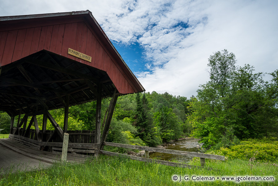
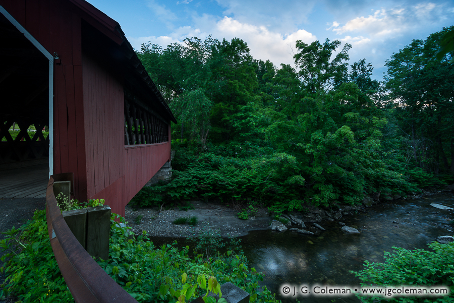
Having spent more than a century and a half amidst the countryside of northeastern Vermont, the time-worn Randall Covered Bridge feels almost as natural a part of the scenery as the surrounding woodlands or the rushing waters of the Passumpsic’s East Branch below.
Randall Covered Bridge is truly a relic from a different era, its rough-hewn timbers assembled the same year that the Civil War came to a close at Appomattox some 600 miles to the south. Records don’t identify whoever was contracted to build the bridge, but the especially wide roof and open sides follow a distinctive pattern endemic to the township and surrounding area.
When the rigors of time and the unforgiving heft of automobiles finally rendered old Randall Bridge obsolete in the 1960s, the people of Lyndon had the foresight to keep the aged timber bridge intact. So, despite having been bypassed decades ago by a modern concrete crossing just 20 feet upstream, Randall Bridge quietly enjoys its 152nd anniversary this year. And with much care and a smidgeon of luck, it’ll be there for generations to come.
Purchase a Fine Art Print or Inquire About Licensing
Click here to visit my landing page for “Randall Crossing at Lyndon” to buy a beautiful fine art print or inquire about licensing.
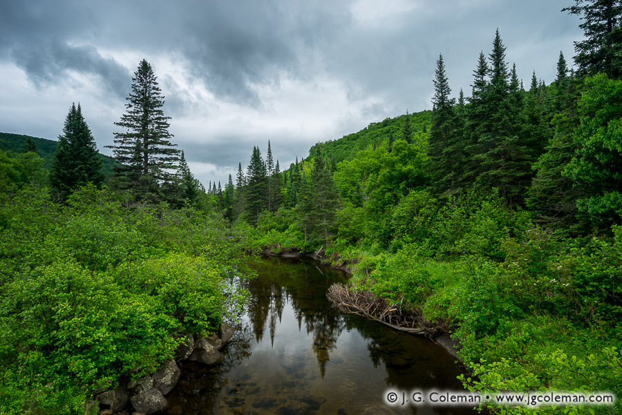
As a rainstorm brews in the clouds above, the Pherrins River lazily snakes through the wilds of Northeastern Vermont, concealing a thriving population of the much sought-after native brook trout.
I produced this piece during a June fishing trip in Vermont’s Northeast Kingdom last year, not long after my friends and I pulled several beautiful “brookies” from pools and riffles along this river. With June approaching once again, I’m growing excited to see where this year’s Vermont odyssey brings me.
Purchase a Fine Art Print or Inquire About Licensing
With at least a foot of snow descending upon most of New England right now, how about a throwback to the inviting warmth of this past spring?
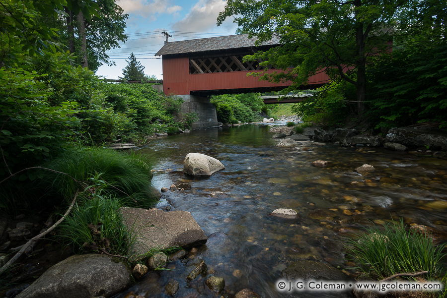
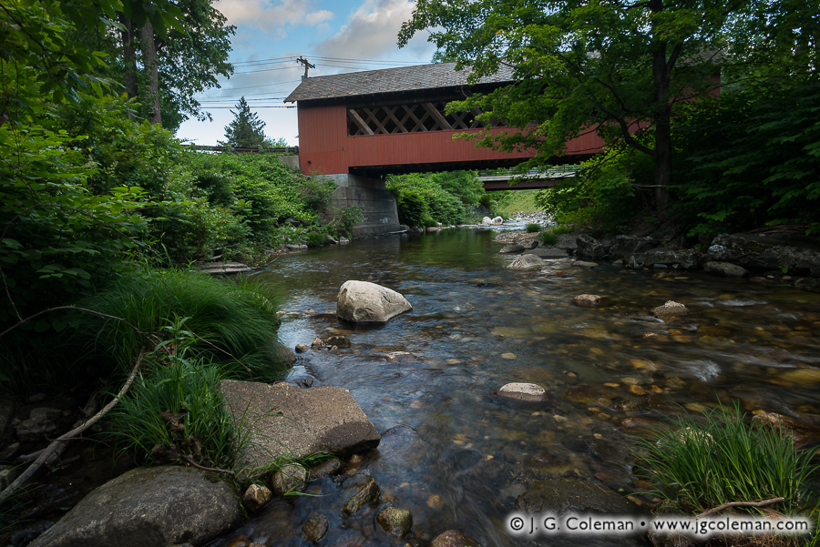
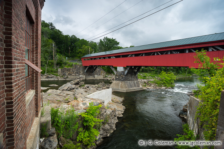
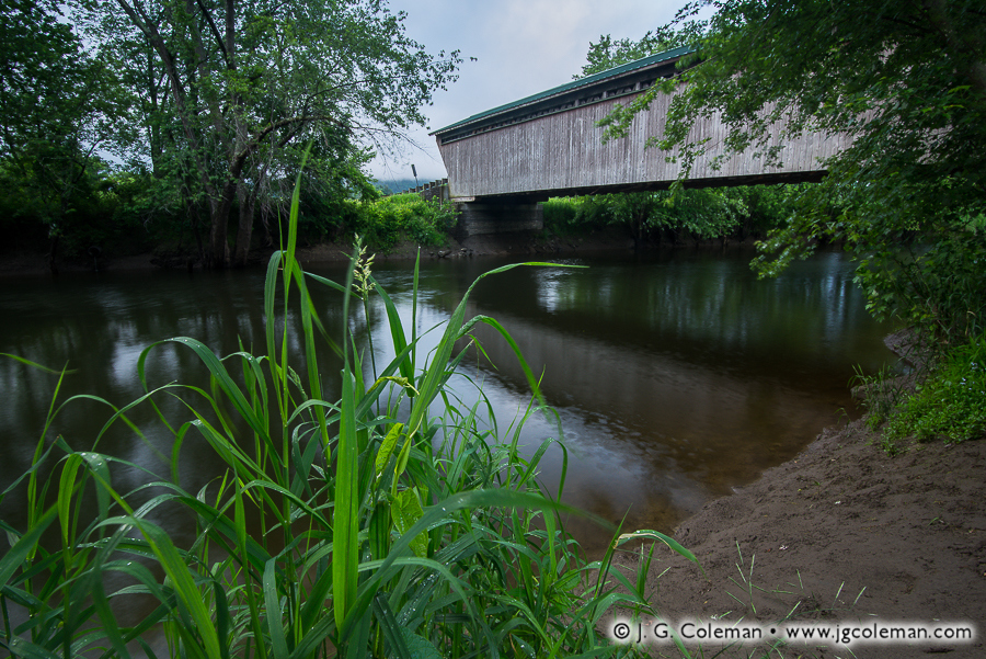
When I arrived at the 137-year-old Creamery Covered Bridge in Brattleboro, it was early June. The surrounding woods were alive with jostling leaves and bird songs and I was serenaded by the murmur of a lively creek as it meandered through the shallow gorge below.
The view from the road didn’t strike me at first, so I made my way down beside the water. “This still won’t do,” I determined, unable to get a clear view of the bridge from the forest-crowded riverbank. Off came my shoes and socks and, with pant legs rolled up, I waded into the cool waters of Whetstone Brook where I found the vista I had envisioned!
Ahhh, those warm days will be back soon enough, folks! Until then, stay warm and avoid wading barefoot in any streams…
Purchase a Fine Art Print or Inquire About Licensing
In my latest release, “Taft’s Crossing on the Ottauquechee” (above), the iconic, 180-year-old Taftsville Covered Bridge reaches nearly 200 feet across the Ottauquechee River in Central Vermont, its robust timber frame perched on massive abutments high above the rugged, rock-strewn gorge below.
Since 1807, the townspeople of Taftsville had been building bridges over the Ottaquechee River in this very spot, only to watch them get washed away by floodwaters again and again over the course of just a couple decades. The impressive Taftsville Bridge, completed in 1836, was intended to buck that exasperating trend once and for all. Today, it stands as one of the oldest covered bridges left in the United States. However, that reputation for endurance nearly came to an abrupt end in 2011 when Hurricane Irene charged through Vermont, bringing record rainfall on the heels of an already wet season.
Rivers all over the state brimmed and erupted from their banks. You’ll notice that the Taftsville Bridge is quite high above the river gorge, perhaps 30 feet or thereabouts. As the hurricane raged, though, the Ottaquechee rose so high that whitewater was crashing furiously against its siding! Remarkably, the bridge was spared and, after a few years of careful rehabilitation, reopened to traffic for its next 180 years of service.
Purchase a Fine Art Print or Inquire About Licensing
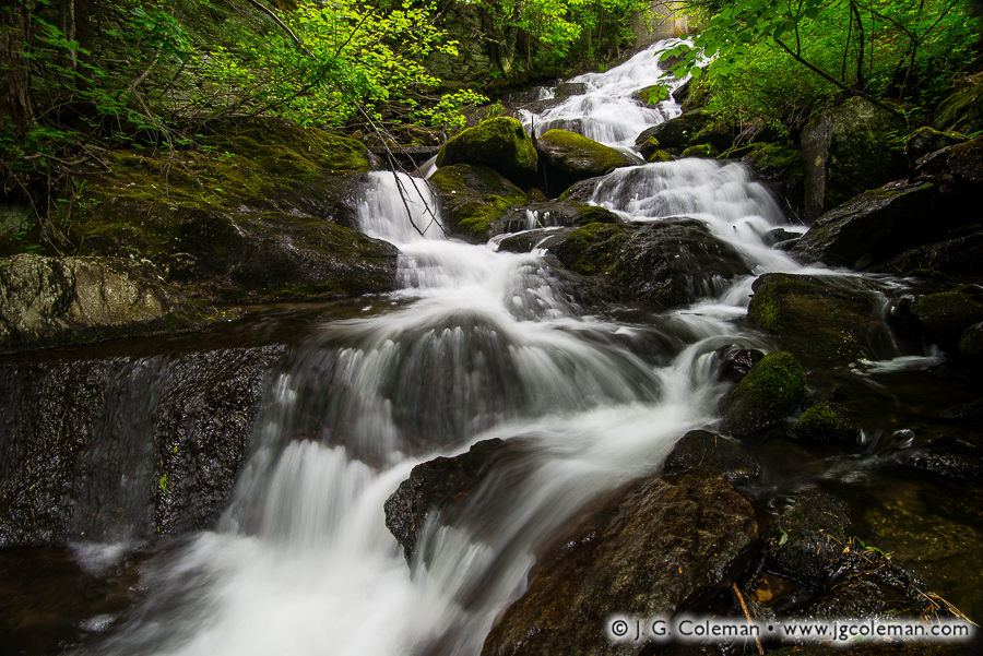
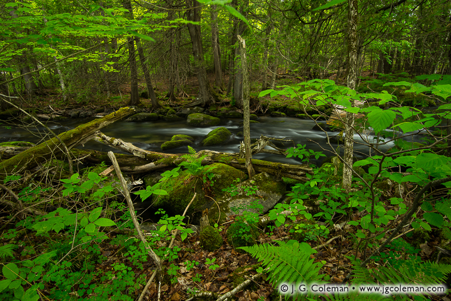
In my new release, “Coburn Hideaway”, dense forest underbrush embraces a vigorous brook which tosses about in a frenzy as it cascades through a gully of glistening boulders. Mosses spread in vibrant blankets amidst the waterfalls, undeterred by the swift current and furious plunges.
When a few friends and I came upon this brook snaking beneath a small bridge in the wilds of Vermont’s Northeast Kingdom, the tell-tale sound of cascading water could be heard echoing up from the forest understory downstream. I couldn’t resist making a descent into the gorge to investigate the waterfall, lugging everything from my camera bag and tripod to my fishing rod and waders.
Without even the faintest trail to follow, the bushwhack down to the base of the falls was grueling. But the absence of a footpath, as well as the overall remoteness of the place, makes it likely that I’ve been the only person in many decades to peer up from the foot of these cascades. That’s worth every scraped elbow and labored breath!
Purchase a Fine Art Print or Inquire About Licensing
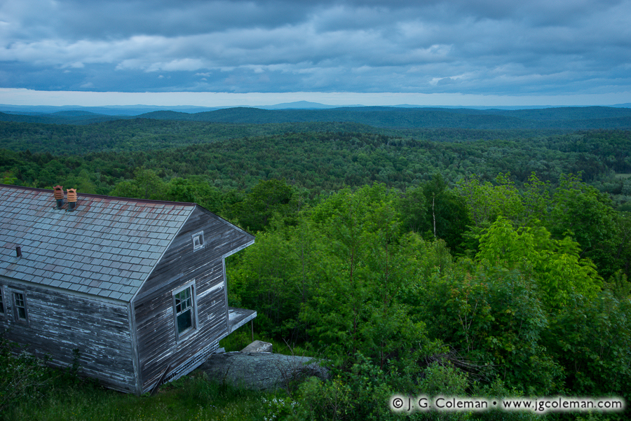
A breath-taking vista, wrought in endless peaks and valleys and lined with wild forests, unfolds before the humble front porch of a rustic, old cabin nestled amidst Vermont’s Green Mountains.
I produced my latest release atop the 2,400-foot Hogback Mountain, a majestic overlook in Southern Vermont fittingly dubbed the “100-Mile View” which peers deeply into the neighboring mountainscapes of Massachusetts and New Hampshire.
Purchase a Fine Art Print or Inquire About Licensing
Riffles on a woodland trout stream purr softly beneath the forest canopy in the wilds of Northern Vermont amidst a luxurious mingling of leaves and mosses.
Vermont’s “Northeast Kingdom” is comprised of the three northeasterly counties in the state, encompassing over two-dozen towns in one of the most spectacularly scenic regions in all of New England. A celebrated patchwork of wild forests and picturesque farmlands nestles into 2,000 square miles of countryside where stirring mountain vistas loom ever-present on the horizon.
Over the coming weeks, I’m excited to be releasing a range of new work from this region of Northern New England which I recently produced in earlier this month.
Purchase a Fine Art Print or Inquire About Licensing
As I stood upon a muddy riverbank during a warm spring morning in Vermont’s Rutland County, I watched reflections of the weathered Goreham Bridge ripple upon Otter Creek beneath a hazy sky streaked with broad, indistinct swaths of luminous blues. My piece, “Goreham’s Crossing at Pittsford”, emerged from that moment and brings together several elements which elaborate upon the sense of place wrapped up in this rustic riverscape in the Green Mountain State.
Built in 1842 and carrying traffic to this day, Goreham Bridge is one of four 19th-century covered bridges remaining in the rural town of Pittsford. That’s no small feat when you consider that the entire state of Connecticut has only three! But the town of Montgomery, about 100 miles north near the Canadian border, can justifiably be called Vermont’s “covered bridge capital”. Remarkably, seven covered bridges are scattered across the township’s 56 square miles.
Purchase a Fine Art Print or Inquire About Licensing
If you’ve read any number of my posts here on From the Field, you probably know that I get a bit nostalgic when it comes to thoughts of the “old days” of Connecticut. You know, the days before the railroads came through, before industry completely transformed the previous two centuries of ever-steady Yankee lifestyle; the days when the state was still a bucolic patchwork of small, quiet towns connected by rough carriage roads. While I’m well-aware that it’s dangerously easy to idealize those bygone days, overlooking the many hardships and inequalities that people of that era faced, I still find something deeply comforting in the thought of a time in Connecticut’s history when daily life didn’t move at the breakneck speeds to which we’ve become accustomed in modern times.
In the 1830s, the population density of Connecticut is estimated to have been only about 60 people per square mile, a far cry from the staggering 750 people per square mile that inhabit the state today. It is presently one of the most densely-populated states in the nation, coming in at fourth place behind New Jersey, Rhode Island and Massachusetts. Indeed, things have certainly changed over the last few centuries. But perhaps a visit to Northern New England gives us a faint taste of what the Nutmeg State might’ve been like 200 years ago.
Fair Haven, Vermont
Take, for example, my new piece titled “Bird Mountain Countryside”, which brings us to Fair Haven, Vermont. Here we are treated to a broad expanse of meadows and pastures that lead our eyes towards the horizon where the monolithic slopes of Bird Mountain rise from a thick blanket of early-morning fog.
The lands of Vermont seem practically deserted in comparison to most places in Connecticut. In fact, the population density of the “Green Mountain State” is less than 80 people per square mile in modern times, rather close to the figure reported for Connecticut so long ago during the pre-railroad era.
After I finished developing this piece, I took a proverbial “step back” and found that it faintly reminded me of the 1849 painting of New Haven’s West Rock Ridge by Frederic Edwin Church, a 19th-century Connecticut-born artist. I won’t indulge in likening myself to this master of the Hudson River School, but I mention Church’s painting because, like my “Bird Mountain Countryside”, it portrays a classic, bucolic foreground coming to a certain crescendo at a prominent mountain in the distance. "West Rock, New Haven" (1849) Painted by Frederic Edwin Church
The big difference here is that my perspective of Fair Haven is current; if you were to stand exactly where I produced this photograph, you’d see the same fields, pastures and meadows. In contrast, Church’s idyllic agrarian New Haven has long ago vanished beneath increased urbanization and, especially, the concomitant phenomenon of suburban sprawl along city margins. In fact, the Hudson River School painters were known to “idealize” the otherwise real landscapes that they painted… so it’s tough to say if Church’s New Haven of 1849 actually even existed as he painted it. Maybe it did, but maybe there’s a measure of fiction blended into his portrayal. We may never really know for sure…
Ultimately, the point remains that what Church was trying to express in his “West Rock” -that is, an image of an agrarian society peacefully co-existing with nature- isn’t far from the reality that exists in modern times at the foot of Bird Mountain. Perhaps it is that the character of “Old Connecticut” is in some sense still alive within the valleys of the Green Mountains.
Killington, Vermont
Our next few destinations on this odyssey are within the town of Killington, Vermont… a place which is undoubtedly famous among Northeastern skiing enthusiasts. However, my latest works from Killington were produced in the warm, humid months of summer… long after the snow drifts had vanished. Indeed, the side of Killington I want to show you is little-known to those who arrive for a few days in the dead of winter and never leave the vicinity of the resort. If we venture elsewhere within the 46 square miles of territory the town encompasses, we find some rather beautiful places that lay off the beaten path.
“Mirror of the Shrouded Hills” (below), my new piece from Killington’s Kent Pond, features one of those scenic treasures. Here we find ourselves overlooking a landscape crowned by thickly-wooded hills and steeped in heavy blankets of lingering mist. Below, the hills are cast from the surface of Kent Pond as a soft reflection, out of which emerges the shadowy silhouette of a small, rocky island populated by only a few lonely conifers seemingly marooned from the surrounding forests.
What originally drew me to Kent Pond, though, was the outlet brook that departs from the body of water on its eastern shores. Some official maps call this stream “Kent Brook”, a name which is as sensible as it is unremarkable. Unofficially, this brook enjoys a much more interesting title: “Thundering Brook”. At the risk of exposing my childishly-excitable side, I will admit that any river called “Thundering Brook” is a river that I simply must see for myself.
My fine art piece, “Green Mountain Riverscape”, portrays a conifer-crowded glade scattered with boulders where Thundering Brook topples over tiers of terraced bedrock before disappearing some distance downhill. This piece was especially gratifying to produce, as I feel that I was able to faithfully capture the very wild and untamed aura that permeates the landscape surrounding the rugged watercourse of Thundering Brook.
“Green Mountain Riverscape” is, in a sense, a timeless vision of Vermont’s natural places, freed of any strict associations with modern times. As I look at the piece I wonder,” Could Thundering Brook really have looked much different 100 years ago? Or 200 years ago? Even 1,000 years ago?” Ordinarily, I dive deeply into the history of the landscapes that I photograph, for I feel strongly that understanding the history of a place brings me closer to its essence. But occasionally I am moved to forgo this craving for knowledge. This vista on Thundering Brook is not far from a well-packed dirt road… beside the brook runs a small-diameter pipeline of indeterminate use… and beside portions of the brook, the banks are well-packed by frequent visitors. But for all of these reminders of the modern world that surround Thundering Brook, there were inevitably instances in which I gazed in just the right direction from just the right perspective and, all of the sudden, it was as if I was looking not only at a river that receded into the distance, but also at a scene that receded deep into the past… so deeply that, for a brief moment, it was as if all the pesky considerations and attachments to clock and calendar, which are so much a part of our modern lives, vanished amongst the cacophony of cascades and waterfalls.
The calming waters of Thundering Brook, as they are seen in “Green Mountain Riverscape”, may not appear to be as furious… as violent… as “thundering”… as one might expect. I’ll admit that Thundering Brook was not exactly a roaring torrent on the day that I visited, a condition that I attribute mostly to the peculiar dry spell that dominated most of New England’s summer season. Every brook I visited this year, from Southern Connecticut to Central Vermont to Eastern New York, was generally at quite a reduced water volume. But given the circumstances, Thundering Brook still had a decent volume of water flowing; I can only imagine that it truly thunders during the springtime, angrily crashing through the forests of Killington as it hauls away meltwater. One source* states that Thundering Brook carries less than 10 cubic feet of water per second (cfs) in the summertime, but notes that “peak events” have seen that figure swell to a staggering volume of just under 800 cfs! Can you imagine the near-cataclysmic power being channeled through this brook?
But even if Thundering Brook was lacking the water volume required to truly live up to its name, the impressive waterfalls along its course were still quite spectacular. “Thundering Brook Falls”, a series of roughly three big drops along the course of Thundering Brook, were the first landmarks that really sparked my interest to conduct a shoot in Killington.
My new piece, “Parallel Worlds”, features the final and tallest waterfall of the bunch. What I found especially intriguing about the views of this 60-foot waterfall was the unusual contrast between the forest and the watercourse. Owing to the green-tinted light filtering through the coniferous canopy, the entire forest in the upper portion of the frame is steeped in warm color tones and the underlying rock is softened by lush carpets of moss. Yet, at the foot of the woodlands we find Thundering Brook Falls cascading over slopes of barren bedrock, jagged and angular and glistening with subtle reflections of the sky above. “Parallel Worlds” leverages this intriguing disparity, inviting us to simultaneously accept nature as both vital and desolate… a source of nurture and a force of hardship. Through the lens of civilization, nature seems to express itself alternately as the giver and taker. There on Thundering Brook Falls, though, these parallel worlds blended seamlessly into a landscape that tapped a more primeval vein of my unconscious. And as I sat by the gorge in the humid early-morning air, the Sun triumphantly breaking through the clouds and casting bright beams upon the woodlands, I was reminded of the words of John Muir: “The clearest way into the Universe is through a forest wilderness.”
To see larger versions of the Vermont landscapes pictured here, simply click on any of the photographs above and you’ll be brought to my online gallery.
To see all of my landscape work from Vermont, be sure to visit my Vermont Gallery at JGCOLEMAN.COM.
* Information on water volume was drawn from the profile for Thundering Brook Falls found on Waterfalls of the Northeastern United States, a website authored by Dean Goss. Be sure to check out his page for Thundering Brook Falls.


")


