When I’m out shooting in the field, I don’t always know for certain how well a given image is going to “work” once I get it back home and start developing it and reflecting upon how well it does or doesn’t fulfill my creative vision. There are times when I find myself in beautiful environments which simply prove too difficult to commit to a two-dimensional composition in a way that’s faithful to my creative expectations. After all, there are all sorts of sensory experiences that contribute to our experience in the outdoors: birds chirping, changing light, clouds drifting overhead, the sound of breeze rushing through the forest canopy, maybe a brisk autumn chill in the early morning or the impressive quietude during a snowfall. Now, there are techniques that can be leveraged to suggest some these qualities in a purely visual, flat image, but there’s no way to truly reproduce them. And sometimes, when those supporting elements are lost, the visual impression that remains just doesn’t quite convey what I’d hoped it would.
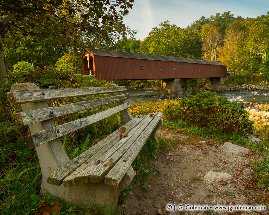
But then again, there are also some outings during which everything comes together beautifully and I know the moment I release the shutter that the imagery I’m producing resonates decisively with my creative vision. “I Dreamt of the Housatonic”, my latest release which I produced last autumn, was created under just those sort of circumstances. When I came by this weathered bench overlooking the Housatonic River and West Cornwall Covered Bridge with soft morning light imparting a gentle glow, it immediately struck me as a golden opportunity.
Having meditated over what drew me so strongly to the scene, it’s tough to pin down any one facet. The image, to me, has a timeless feel that is largely removed from immediate associations with modern life. No cars, no houses with satellite dishes, no joggers in Under Armor, no power lines lazily draped across the river. Putting aside the fact that it’s clearly a modern color photograph, the scene could just as easily have looked almost identical to an observer in 1900 as it did in 2017 (okay, okay… maybe metal road signs weren’t as common back then, but you get my point). And to my sensibilities, that timeless quality also contributes to a somewhat dream-like feel: as if we might find ourselves whisked away in a blissful dream to this quiet bench in the countryside, enjoying the amaranthine solitude of a peaceful, rustic riverscape.
Purchase a Fine Art Print or Inquire About Licensing
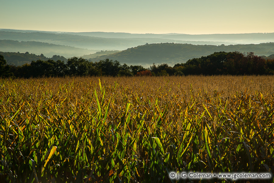
Crowded stalks of corn reach skyward from a humid field, the crops abruptly giving way to misty woodlands and the dreamy silhouettes of Connecticut’s Litchfield Hills.
While the crops grown throughout New England these days span a broad range from apples and blueberries to green beans and pumpkins, there’s no question that corn still reigns supreme. Whether for grain or silage, corn occupies tens of thousands of acres throughout the state. The only crop more common is one that would never make it to our dinner plates: hay and other forage crops that generally feed farm animals.
Purchase a Fine Art Print or Inquire About Licensing
A flurry of shoots all over Connecticut and Massachusetts during this past autumn has left me with a backlog of some 2,000 photographs which I’ve been meticulously processing since mid-December. There’s so much new imagery that I’m eager to share over the coming year!
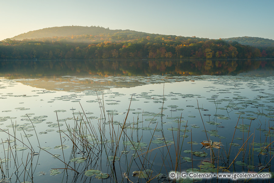
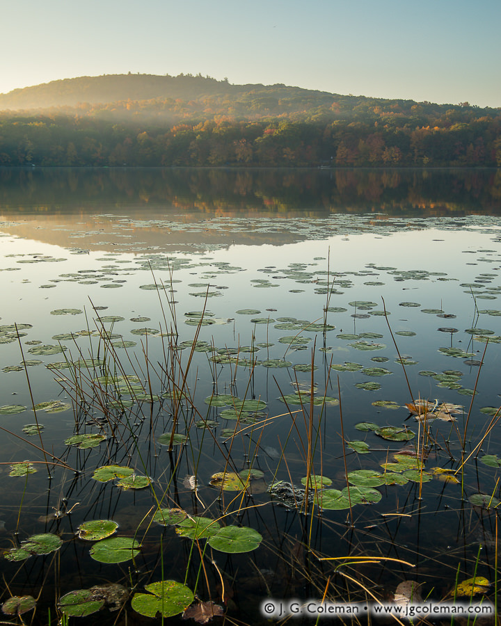
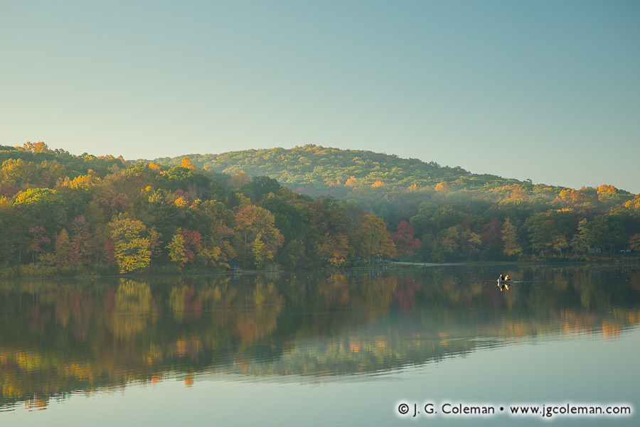
For now, I’d like to offer a couple pieces that I finished developing last night. In “Waking the Shadows of Mount Tom” (at top), we find ourselves amidst lily pads and grasses on the shores of Mount Tom Pond during mid-October. Sunlight breaks over mist-laden hills in the distance as dawn lends comforting warmth to the landscape. The same luminous morning offered a dreamy backdrop for “They Who Dwell in Reflections” (below), in which we find a solitary boat of fishermen amidst the the majesty of autumn forests, morning haze and the mirror-like waters of the pond.
Despite being a fairly small lake, at only about 55 acres, Mount Tom Pond actually straddles a “tri-point” of town boundaries. So while the bulk of open water is in Litchfield, the southern end of the pond reaches into Washington and the eastern shore of the pond falls within in Morris.
Purchase a Fine Art Print or Inquire About Licensing
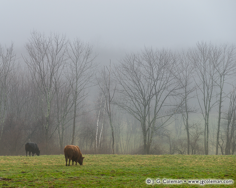
Cattle wander aimlessly through a silent pasture veiled in heavy fog which clings to the Litchfield Hills. Though springtime arrived a few days earlier, dormant woodlands at the farm edge still reach skyward with bare branches.
As if the leafless forests weren’t a stark enough reminder of colder months past, Connecticut is expecting another few inches of snow today. In the words of 19th-century author Edgar Nye: “Winter lingered so long in the lap of Spring that it occasioned a great deal of talk.”
Purchase a Fine Art Print or Inquire About Licensing
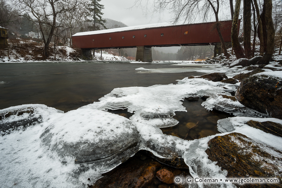
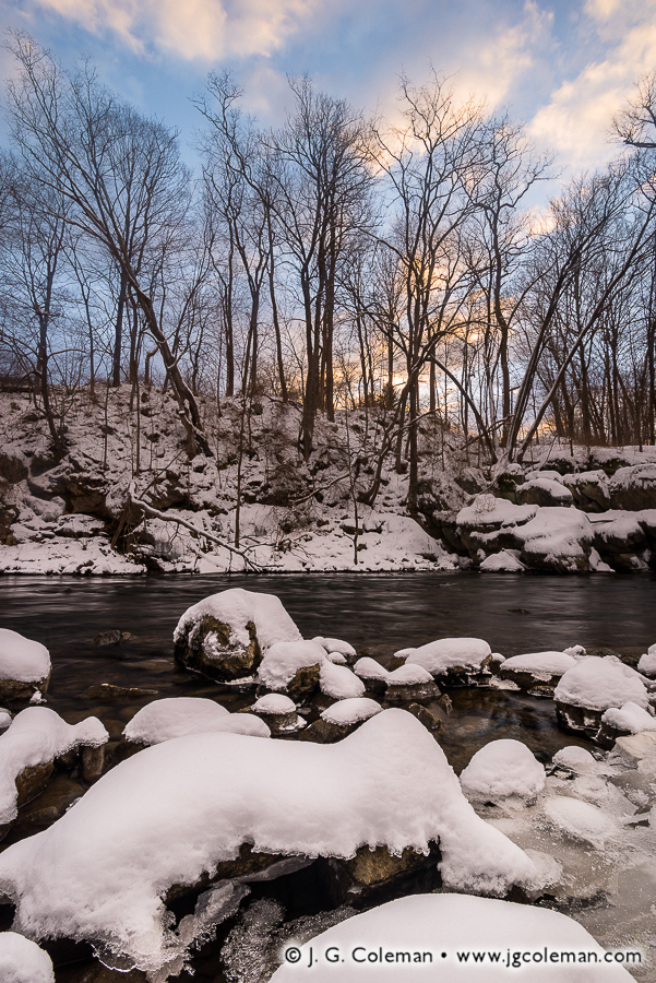
A jacket of snow-dusted ice clings to shallow boulders along the banks of the Housatonic River in Connecticut’s Northwest Hills. Further upstream, against a backdrop of foggy woodlands and steep hills, a long covered bridge faithfully spans the frigid gorge.
At more than 170 feet in length, the West Cornwall Covered Bridge is arguably the most impressive bridge of its type left in Connecticut. Given the cost of maintenance and increasingly heavier loads it was forced to endure since the mid-1800s, it’s nothing short of a miracle that the bridge has survived to the present day.
There were low points along the way, of course. In 1945, a tanker truck broke through the bridge floor and crashed into the river below. A couple decades later in the late 60s, state officials contemplated tearing it down, but were met with vehement opposition from the surrounding community. Instead, it was reinforced with carefully-hidden steel underpinnings, ensuring the bridge would stick around for several more generations to come. The project was a marvelous success, even earning Connecticut an award from the Federal Highway Administration for exemplary historic preservation.
Purchase a Fine Art Print or Inquire About Licensing
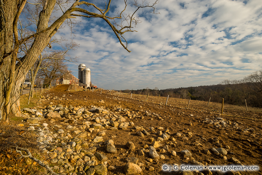
Fences weave through a rock-strewn pasture in the northwest of Connecticut, converging at the crest of the nearby hill crowned with barns and silos. Clouds marble the blue sky overhead, fanning out over the dairy farm and the distant, wooded hills.
“Stones… Connecticut’s state flower!” As a child, I always had a laugh whenever my father related that classic New England joke. Of course, as I grew older and began trying to dig or drive rebar on my own property, the state’s characteristic rocky soil ceased to be a laughing matter. That was especially the case for many Connecticut farmers in earlier times: they toiled endlessly with the burdensome task of hauling stone out of their fields.
For that very reason, agricultural pursuits in particularly rugged areas of the state always tended towards livestock. Since the pastureland used for raising dairy cattle or sheep didn’t have to be plowed, it didn’t demand nearly as much meticulous stone removal.
Purchase a Fine Art Print or Inquire About Licensing
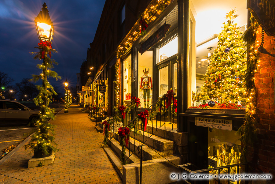
With this unseasonably warm weather, it may not feel quite like December here in New England… but things are looking beautiful nonetheless!
As I was headed out to New Preston for a shoot in the early morning a few days ago, I noticed all of the beautiful, lighted storefronts lining the town green in Litchfield. Although I didn’t have much time to spare if I was going to get to my destination before dawn, I simply had to stop and work with a few compositions. I was so pleased to review the results later in the day; the warm feel of this decorated streets certainly embodies some of the more nuanced feelings of that elusive “Christmas spirit”.
Purchase a Fine Art Print or Inquire About Licensing
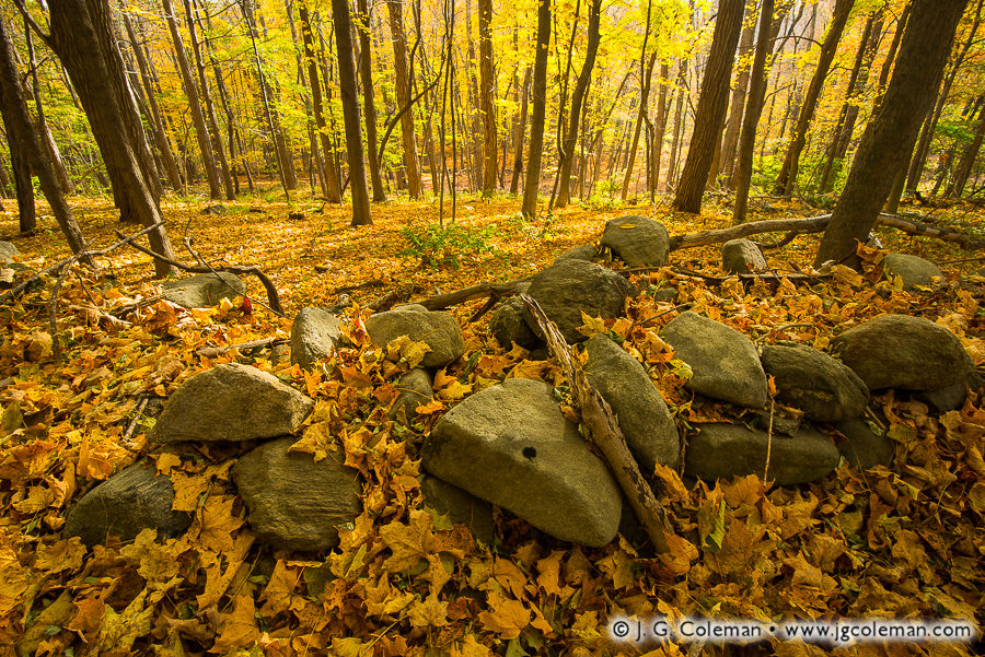
Parched maple leaves blanket the forest floor, rustling amidst an old fieldstone wall which has been toppled by more than a century of fallen trees and frost-heave. Fiery autumn light erupts through the woodland canopy before us, awakening the landscape to a pleasant warmth that grows ever-scarcer as the season wanes.
Fieldstone walls such as this one generally date back to the 1800s. Tens of thousands of miles of them criss-crossed the landscape in that era as the stony soil of New England farms was laboriously combed free of rocks. But why would a farmer have built a stone wall in the woods, as we see here?
It may be hard to believe, but this stone wall is far older than the surrounding forest. Had we stood in this very spot in the 1860s, for instance, we probably would’ve looked beyond this wall to see open pastureland stretching to the horizon. The woods that we see now wouldn’t even have sprouted until decades later as agriculture declined and expansive farmlands were abandoned to the hand of nature. These days, Connecticut is host to roughly 3,000 square miles of forest which feels as old as time itself, yet most of it began growing on deserted farmland little more than 150 years ago.
Purchase a Fine Art Print or Inquire About Licensing
Contact J. G. Coleman to buy a beautiful fine art print of “Sylvan Divine” or inquire about licensing this image.
With the recent weather here in Southern New England mercifully cooling, it seems timely to remind everyone to enjoy what’s left of the summer. If there’s a lingering shred of superstition in your bones, you’ll take heed that the Farmer’s Alamanac calls for “copious amounts of snow” during the coming winter with the “coldest outbreak of the season” predicted for late January.
I produced the piece seen here along the wintry banks of the Housatonic during the final week of January earlier this year. The riverscape that morning lent a certain presence to nature’s penchant for paradox; awakening with splendor, yet still so very dormant… at once, both enchanting and foreboding. “Schaghticoke Rising” (above) was my effort at capturing that bewildering contradiction as it unfolded in the minutes before dawn.
For the curious minds out there, the title of this piece hearkens back to the earliest days of Kent when the remnants of declining native tribes across Connecticut took refuge from encroaching Europeans in the rough, wooded hills of the township. Calling themselves the Schaghticoke (usually pronounced Scat-uh-cook), this amalgam of native peoples became one of the largest indigenous nations in Southern New England. They were also granted one of the earliest reservations ever created in the New World, obtaining some 2,500 acres from the Connecticut Colony in 1736.
Purchase a Fine Art Print or Inquire About Licensing
Connecticut’s Northwest Hills, encompassing roughly 1,000 square miles and 20 municipalities, are oftentimes thought of as the “the backcountry” of the Nutmeg State. These highlands are largely a rough and mountainous terrain, deeply-furrowed with valleys and river gorges that cut between several of the highest summits in the state. Conspicuously avoided by Connecticut’s major highways, the region is largely traversed by winding, woodland backroads. It is perennially colder here than the rest of the state, usually receiving the most snow and being the last area of Connecticut to see that snow melt away in the Spring. The population density is unusually low at only about 140 people per square mile, fully five times more sparse than that of Connecticut as a whole.
Even if Connecticut’s “frontier days” came and went centuries ago, the Northwest Hills are nonetheless host to lost vestiges of that bygone era; places that feel as if they were somehow left behind as time pushed forward. My latest work from this corner of the state illustrates just a couple of the enchanting landscapes that draw me back time and time again whenever I am moved to head northwest, out of the population centers of the Connecticut River Valley and into these rural wilds.
White Memorial Conservation Center Litchfield, Connecticut
In my piece, “Ethereal Passage”, a seemingly endless boardwalk invites us to wander into a twilight dreamscape of lush wetland foliage. As we follow the dimly-lit pathway, we all but lose ourselves in mist-laden forest silhouettes beneath a sky painted with delicate wisps of clouds that foreshadow the approaching dawn.
Despite the surreality of “Ethereal Passage”, it portrays a place which is very real, indeed. These wetlands lie on the fringes of Little Pond, a small body of water within the vast 4,000-acre White Memorial Conservation Center in Litchfield, Connecticut. Encompassing more land than even the largest of Connecticut’s state parks, the White Memorial Conservation Center is a most impressive effort in the preservation and management of the wilds of the Northwest Hills. A varied array of plant and animal life flourish within the Center’s six square miles of forest, rivers and ponds, open fields, wet meadows, swamps and vernal pools.
The origins of the White Memorial Conservation Center revolve around Alain White, a wealthy man whose dedication to preserving natural places began in the early 1900s and ultimately saw him becoming one of the most influential figures ever to exist in the history of Connecticut conservation efforts. The story begins at the banks of Bantam Lake in Litchfield in 1908, where Alain is said to have had something of an epiphany while fishing with a good friend amidst the quiet countryside. As if all of the sudden realizing his life’s mission, he commented that it would be grand if the landscape could remain in its peaceful and largely-undeveloped condition well into the future.
In that day in age, the idea of setting aside land to be protected from development was still relatively new; many industrious Americans insisted that the practice was as preposterous as it was wasteful. And, if he was so inclined, Alain could’ve simply shrugged off his passing idea, finished his day of fishing, and gone about his life no different than before. But, as unlikely as it may seem, that fleeting thought seized upon his consciousness and blossomed into a far-reaching campaign of preservation. In total, Alain and his White Memorial Foundation contributed nearly 6,000 acres of open space to the State of Connecticut, mostly for inclusion in state parks and state forests throughout Connecticut’s Northwest Hills.
Roughly 4,000 additional acres of land, comprising the White Memorial Conservation Center in Litchfield, now surround Bantam Lake… the very place where, little more than a century ago, Alain White sat patiently with his fishing rod waiting for a bite, entertaining the lofty idea that there was something inherently important in ensuring that future generations could find peace in places of nature. Certainly, he drew from the same deep intuition as the great John Muir, who wrote that “everybody needs beauty as well as bread, places to play in and pray in, where nature may heal and give strength to body and soul.”
And with that, I introduce to you another of my new works from the White Memorial Conservation Center: “Bantam River Quietude”. In this work, we overlook the calm waters of the Bantam River as they depart from Little Pond on their way towards nearby Bantam Lake. Mirror-smooth water reflects the soft colors from above so strongly that it is almost as if the Bantam River is fed by the sky itself. Only the wetlands, alive with pickerelweed and grasses and softened by a lingering mist, frame the the scene and provide orientation.
“Bantam River Quietude” is an expression of simplicity and serenity; an attempt to access that state of peaceful contemplation that Alain White found on that fateful day beside Bantam Lake.
Housatonic River Kent, Connecticut
Our next stop in the Northwest Hills brings us to the banks of the scenic Housatonic River, specifically that stretch which cuts through the old Bulls Bridge section of Kent. In 1897, Francis Atwater wrote in his book, History of Kent, Connecticut, that “the lover of the beautiful can see something fortunate in the circumstances which protected Bulls Bridge from the roar of the great world and left it sequestered and almost as picturesque as in its pristine days before the white man came and made his wide clearings.” According to Atwater, the railroad never quite made its way to Bulls Bridge. So, while so many previously small towns in Connecticut began to blossom into small cities with the advent of the rail in the mid-1800s, Bulls Bridge seemed to have been left behind.
Although Atwater wrote those words over a century ago, little has changed in the interim. Even as the importance of the railroads began to atrophy with the popularity of personal automobiles, Kent has continued to remain mostly rural and sparsely-populated. And, indeed, we can still see “something fortunate” in the sheer breadth of natural beauty that has been spared within Kent.
Take my new piece, “Housatonic Summer”, for instance. Here we are treated to a view of the boulder-laden Housatonic River as it furiously cascades southwards on its journey towards Long Island Sound, still some 40 miles away. The dense forest which crowds the riverbanks glows with vitality in the potent sunlight of late-morning. High above, the airy clouds against a bold blue sky top it all off. “Housatonic Summer” is more than just a journey into this riverscape of the Northwest Hills: it is a celebration of those perfect summer days that we’ve all come to love, no matter where we may live.
But this particular stretch of the Housatonic is rather unique for a few reasons. Only a few hundred feet downstream from this vista is Bulls Bridge, one of Connecticut’s only two remaining covered bridges that are still used by traffic. One might guess that the old village of Bulls Bridge was named after this bridge, but the exact opposite is the case. For roughly 250 years, the Bulls Bridge area of Kent was simply a well-known locale where the Housatonic River could be crossed. There were at least a few different bridges built there, beginning with one purportedly constructed by the Bull family, which ran an ironworks closeby in the mid-1700s. The wooden bridges of those early days didn’t have nearly the longevity of modern bridges, so as one wore out another would be built. It’s not clear exactly how many different bridges spanned the Housatonic in Bulls Bridge over the centuries, but the current version was not constructed until the mid-1800s. Spanning a distance of more than 100′ across the river, the bridge eventually received modern metal underpinnings which have strengthened it enough to allow a single lane of traffic to pass through on a daily basis.
Perhaps even more impressive are the gaping, smooth-bored holes in the limestone outcroppings that flank the western side of the river beneath the bridge and extend about 300 feet upstream. Known as “giant’s kettles” or “giant’s cauldrons” (or occasionally just termed “potholes”), these deep pits are the result of abrasive detritus like sand and stones getting caught in depressions in the bedrock floor of the river. As eddies in the water swirl them around and around, they gradually grind more deeply into the depression. Over the course of hundreds or thousands of years, this gradual grinding action can carve some surprisingly deep pits in solid stone.
One of these cauldrons is prominently featured in my new piece, “Giant’s Kettle on the Housatonic”. Producing this photograph required a good deal of planning and patience in order to fulfill my vision for the the shot. While I knew that I wanted to highlight one of these remarkable limestone rock formations, I needed to find a perspective from which I could capture all the elements that come together to make this stretch of the Housatonic such a captivating place. After scrambling some distance upon the pock-marked riverside bedrock, I came to the kettle you see here, which seemed to offer the opportunity I’d been seeking. Something as simple as setting up the tripod was quite challenging, since the only surface available was deeply-pitted limestone. Even once I managed to haphazardly brace the tripod legs, I had to wait over an hour for the perfect lighting conditions: bright enough to illuminate the vicious currents of the Housatonic that carved these kettles, but also subtle enough that I could simultaneously capture detail within the smooth, shadowy kettle in the foreground, where foamy water still endlessly swirls away, grinding an ever-deepening cauldron in the stone. All of the time and effort certainly paid off though, for in creating “Giant’s Kettle on the Housantonic”, I was able to swallow up the full magnificence of this grand riverscape.
Want to See More of Connecticut’s Northwest Hills?
There’s little doubt that the Northwest Hills of Connecticut figure quite prominently in my work; acre for acre, I find them to be some of the most wild and picturesque places in the state. Several of the most stunning landscapes in this region are featured in my artwork, so I’ve listed some collections below that will bring you ever deeper into this magical corner of Connecticut. Also, be sure to check out two of my previous posts —”Rivers & Streams Emerging from Winter” and “Car Troubles on the Way to Kent“— both of which discuss Kent Falls (located in Kent, only about 10 miles northeast of Bulls Bridge).
Kent Falls is probably Connecticut’s most well-known and scenic set of waterfalls. I’ve spent more time here than almost any other individual park in the Northwest Hills, capturing views of the remarkable limestone cascades and the wonderful transformations that occur with each season.
Located mostly in Norfolk, this is the only Connecticut state park which is not entirely located within the state’s borders. The northern tip of the park juts into Massachusetts, which jointly owns and maintains the park.
Encompassing some of Connecticut’s oldest hemlock and white pines, the old-growth forest of Cathedral Pines Preserve in Cornwall has recently been dubbed a National Natural Landmark by the federal government.
These three nature preserves, all located within Washington, Connecticut and owned by the Steep Rock Association, are amongst some of the most beautiful open spaces in the state.
Located in the rough woodlands of Roxbury, Connecticut, Mine Hill was once the site of a 19th-century ironworks, not unlike those that operated all over the Northwest Hills in those days. The roasting ovens and iron furnace still stand eerily amidst the forest, even though the area is now a scenic nature preserve.