“A brook there is all children know,
Upon whose banks the wild flowers grow;
A brook that from its hill runs down,
And wanders wanders past the town.”
-Susan Pendleton
“Hebron” (1908)
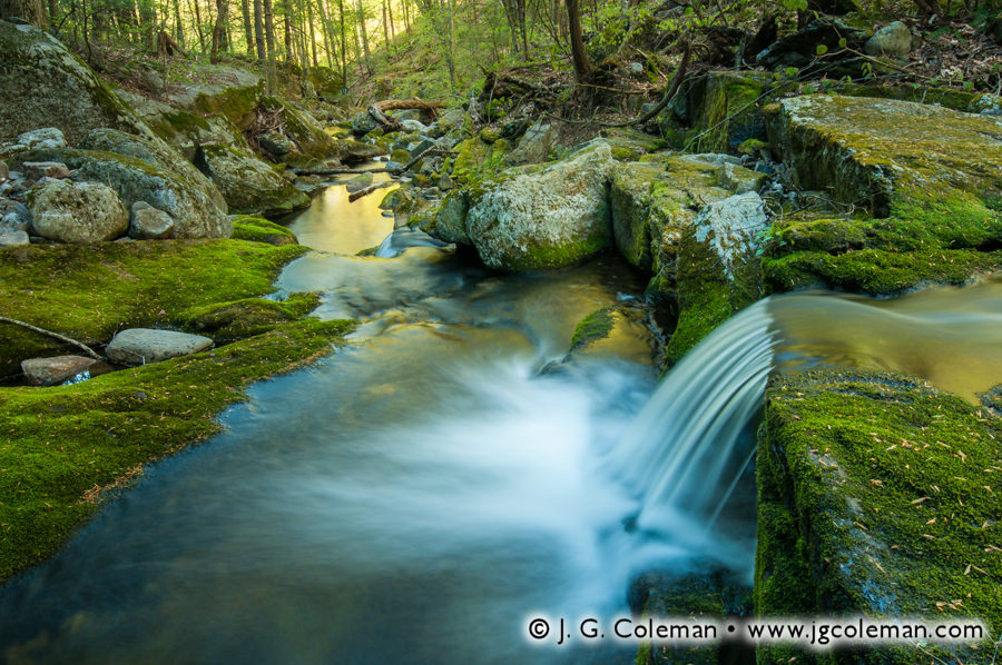
Grayville Falls is a hidden gem nestled in the wooded wildlands of Hebron, a small town which bridges the low-lying Connecticut River Valley to its west and the hilly uplands of Connecticut’s “Quiet Corner” to its east. Although these falls had been on my must-see list for a few years, my attention was somehow routinely pulled elsewhere even as I passed within only a few miles on my way to shoot at more distant locations. It wasn’t until last summer when I finally managed to get out to the forests of Hebron on a warm July morning to visit Grayville Falls for the first time.
Grayville Everlasting (above), one of my pieces from that shoot, embraces the essence of these tranquil cascades on Raymond Brook, beginning with their steady persistence. Over thousands of years, Grayville Falls has ceaselessly carved its way deeper and deeper through several feet of stratified bedrock, leaving shadowy recesses along the periphery of the brook where weaker layers of stone have been gouged out by running water.
There’s also a measure of human history to be found at Grayville Falls, as evidenced by the remnants of a large boulder dam that rises over the cascades in Grayville Everlasting. In Hebron’s earlier days, when industry was still tethered to water power as the sole means of animating machinery, William Gray operated a carpet factory along the banks of Raymond Brook. The dam ruins we find today suggest that Gray utilized a fairly crude dam constructed of boulders and earthen mortar to impound several thousands of gallons of water upstream, ensuring that his factory could run even during dry spells.
Interestingly, old William Gray wouldn’t have recognized the name “Grayville Falls” during his lifetime. That name didn’t appear until the 1970s, when Hebron purchased the property for use as parkland and held a town-wide contest to determine what it would be called. “Grayville Falls Park” emerged as the winning name; a clever tip of the hat to a man that might otherwise have been lost to history.
“I saw, as for the first time, what a severe yet master artist Winter is. Ah, a severe artist! How stern the woods look, dark and cold and as rigid against the horizon as iron!”
-John Burroughs
“The Snow-Walkers” (1866)
What better way to kick off the New Year than celebrating the quietly beautiful snowscapes that are a hallmark of wintertime in New England? My new piece, Mad River Lullaby, was produced only a few weeks ago and portrays a broad bend on the Mad River as it snakes through snowy woodlands just down the road from my home in Wolcott, Connecticut.
The Mad River is impounded downstream of this vista to create the 120-acre Scovill Reservoir, so the serpentine meander featured in Mad River Lullaby is typically inundated. In this rare instance, however, the reservoir had been drawn down several feet, allowing the Mad River to briefly reclaim its more natural footprint. Freshly-fallen snow, courtesy of a December storm, delicately frosted the bare trees and “tidied up” the muddy cobble left behind as the reservoir receded.
Throughout 2013, I managed to travel all over Connecticut and Western Massachusetts and even enjoyed a couple jaunts into Vermont and Eastern New York. Nature was not so shy during many of these travels, presenting several opportunities to capture rare and intimate glimpses of her beauty wherever I set off into the landscape. But, as nature photographer Moose Peterson once said,” The real prize is what you bring home in your heart, not on your memory card.” Indeed, when I browse through my work from this past year, I recall countless fulfilling days of being out in the wilds. Those experiences… those memories… are the reason that I love this art form so deeply.
To all of my viewers, I wish you and yours a bountiful and memorable new year in 2014!
“Be like the sun and meadow, which are not in the least concerned about the coming winter.”
-George Bernard Shaw
Wildflowers are something of a staple subject for landscape photographers, not only for their vibrant color, but also for their exquisite structure. For while we can certainly find exceptional colors in a sunset sky or an autumn forest, neither can offer quite the same delicate complexity as wildflowers. However, incorporating wildflowers into an effective landscape photograph can be challenging. Timing is everything. Not only must a landscape photographer seek out conditions that are universally important for aesthetics, but he must also be especially attentive to the season in which certain species bloom. The trick is to seize those rare moments when weather, lighting, location and seasonal blooms intersect; that sweet spot is elusive, but it can potentially yield idyllic scenery.
Similar elements come together in a much different composition in Pomperaug Summer (at right), in which clusters of bergamot extend deeply into a meadow, mirroring in small scale the crown of the solitary, whimsical pasture tree that stands silhouetted against the distant, fog-laden forest.
Encompassing roughly a square mile of territory beside the Pomperaug River in Southbury and criss-crossed with some 15 miles of trails, Bent of the River Audubon Sanctuary is actually larger than many of Connecticut’s state parks! Quiet, forested hills cover most of the expansive property, while the area nearby the visitor center consists of the broad, open meadowlands portrayed here in my work. But if the scenic qualities of this place are readily evident, what is not so obvious is the story behind it’s perplexing name.
For nearly six decades prior to its ownership by the Audubon Society, much of the land was the private estate of Howard and Althea Clark. At some point, while perusing the old land records associated with property, they discovered an early 1702 deed that referred to a sharp turn of the Pomperaug River beside their driveway as “ye bent of ye river”. Passionate as the two were about living out in the countryside, surrounded by hundreds of acres of serene seclusion, it may well be that the Clarks found something romantic and nostalgic in this old-fashioned language, suggestive as it is of colonial-era New England. The novel reference made enough of an impression upon the couple that, when Althea passed away in 1992 and left the full extent of the property to the Audubon Society, one of her posthumous demands was that it should be called “Bent of the River”.
Although the Clarks were indeed wealthy, they seem to have accumulated this wealth early in life and were subsequently able to indulge in various artistic and literary pursuits. Howard managed to become a novelist and published at least a few books. For her own part, Althea enthusiastically took to photography, an art at which she is said to have excelled. Try as I may, I was unable to find any example of her work online. But given the bucolic surroundings in which she and Howard chose to live, it isn’t unreasonable to imagine that landscapes factored into her subject matter quite frequently. Indeed, I wonder if one day I might finally happen upon some of her old black-and-white prints and maybe… just maybe… I might find among them some vista of a broad, open meadow, sprinkled ever so delicately with sprays of wild bergamot.
While traveling throughout Connecticut and Greater New England to photograph our diverse landscapes, I am constantly striving to produce visions of nature that convey a distinct sense of place. Wildlands never fail to inspire in me a range of emotional responses -from awe and joy, to nostalgia and melancholy- and I seek to distill those reactions into potent visual expressions. Indeed, the interpretive approach to landscape photography forms its very foundation as an art form. “Falls Brook Awakening”, my latest piece, exemplifies the sort of engaging and emotive perspectives that are possible when we’re receptive to the subtle character of the land.
In “Falls Brook Awakening”, we find ourselves deep in the forests of Hartland, Connecticut, peering downstream as Falls Brook wanders excitedly through a mossy gorge of boulders and bedrock. We are at first greeted by a lively waterfall coursing over a weathered ledge, and as we follow Falls Brook into the distance, we discover that its waters glow with vibrant reflections of the woodland canopy above. In the distance, crowded spring foliage is illumined by the luxurious light of early morning. The entire landscape is waking up from its nighttime slumber and we get the front row seat.
Falls Brook is really just a small taste of the natural treasures contained in Connecticut’s vast Tunxis State Forest. Encompassing more than 9,000 acres and spread across three towns, the Forest’s expansive wooded landscapes possess a truly wild character that permeates the body and soul alike.
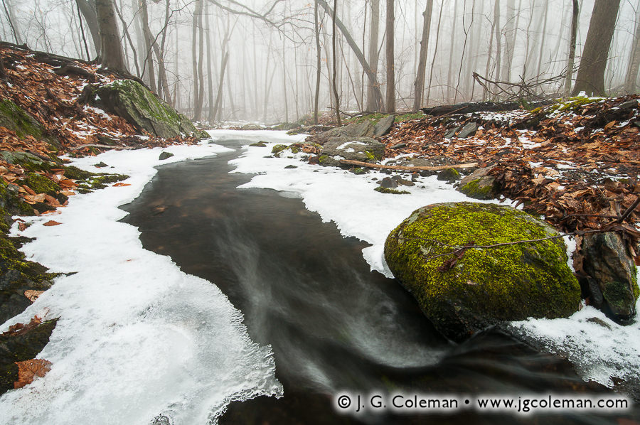
With winter behind us and the spring renewal ahead, I find myself looking back through my last three months of work in search of the highlights of the past season. There have certainly been plenty, from a golden sunrise over the frigid Shepaug Valley in Washington to the icy cascades of Wepawaug Falls in the forests of Woodbridge (photo above). By far, though, my most enjoyable shoot this past winter was at the Ansonia Nature Center, a 150-acre parcel of woodlands and wetlands in Southern Connecticut.
I’ll be the first to admit that a small nature preserve in the equally small town of Ansonia, nicknamed the Copper City for its manufacturing prowess, hardly seems like a promising place to pursue the wild and rustic qualities that form the core of my landscape work. Factor in the high population density —more than 3,000 people per square mile— and you might just think I’ve lost my mind. But the fact of the matter is that you don’t need a thousand miles of wilderness to feel as if you’re thousands of miles away from the din of civilization. Within this swath of forest in Ansonia, I found a cozy microcosm of Connecticut’s natural landscapes.
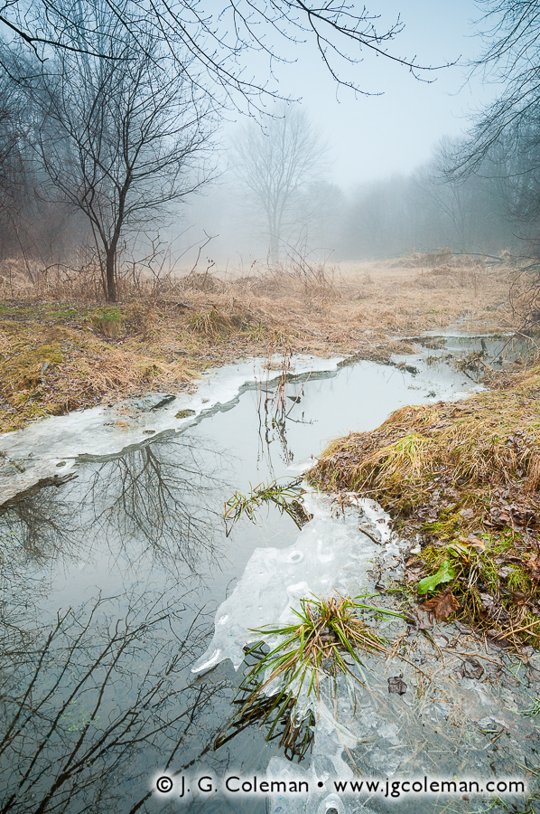
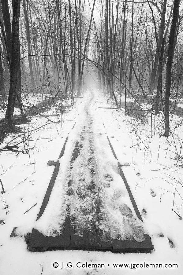
Every open space worth its salt, for example, ought to have a watercourse of some kind. Two Mile Brook, a small stream that snakes its way through the western side of the Center, fits the bill and even possesses a delightfully dynamic character. When I first crossed this brook, only a few minutes into my hike, I found it lazily meandering through a wet meadow (photo at right). So subdued was its pace that its surface reflected the branches of nearby trees with mirror-like fidelity.
Yet, when I hooked back up with the Two Mile further north, it had an attitude altogether different. Now a lively brook, it weaved its way through the forest, dodging mossy boulders and murmuring energetically with occasional riffles. Indeed, the sound of a woodland brook is an aesthetic must-have that complements the Nature Center’s property nicely!
What’s more, Two Mile Brook has actually enjoyed quite a good deal of attention historically. As far back as the late 17th-century, it served as a useful landmark when drawing up property deeds. When the town of Derby was incorporated in 1720, for instance, Two Mile Brook was cited as its southern boundary. The banks of Two Mile Brook were even home to a number of mills throughout the 1800s, albeit in the more southerly stretches of the stream after it has gained some additional water volume and momentum.
Now is as good a time as ever to mention that, during my visit, the Ansonia Nature Center was cloaked with an absolutely exquisite blanket of mist. The temperature had managed to rise above 50° F, truly a rare occurrence for a late-January day in New England! The resulting mass of warm, humid air conjured a balmy fog that drifted across the landscape instilling an aura of both serenity and mystery. Conditions like this bring a veritable treasure trove of possibilities to a nature photographer, offering a marvelously ethereal means of conveying depth in a scene, as well as impeccably diffuse light that gently coaxes detail from shadowed surfaces.
Needless to say, even this spell of unusually warm weather wasn’t enough to melt away the ever-present traces of winter. Redwing Pond was still frozen over, such that rocks in the shallower sections sat half-entombed within motionless swirls of textured ice. Even along the woodland trails, there was no doubt that nature remained dormant. The only sounds to be heard were the occasional rustle of grey squirrels as they leapt cautiously from tree trunks to the forest floor, digging feverishly for hidden food stores amongst snow and thawed leaf litter.
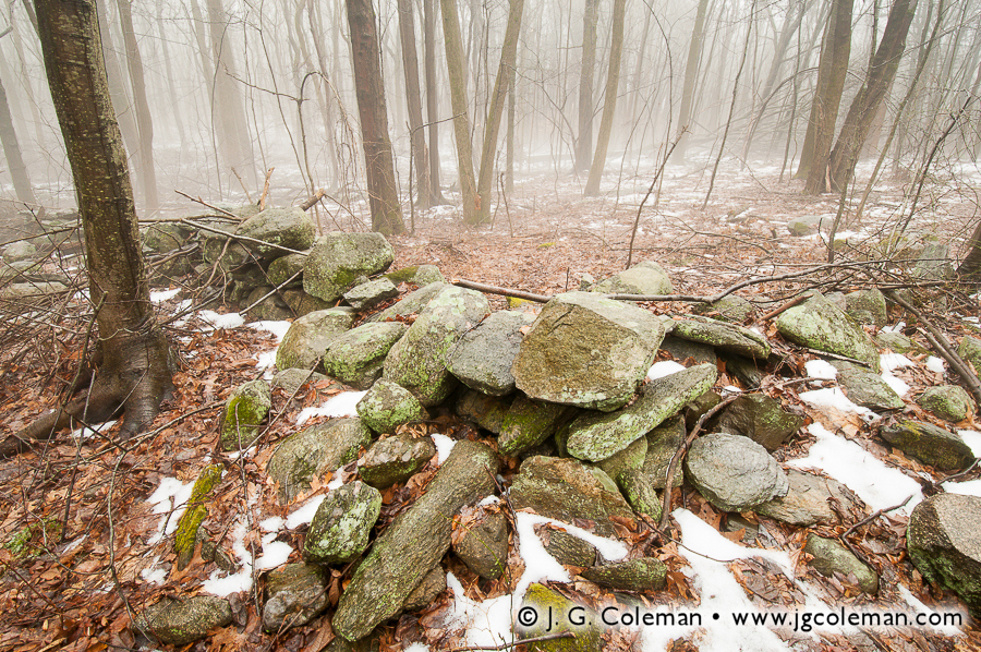
Within the woodlands of the Ansonia Nature Center, we also find telling traces of human presence from a bygone era. Much of the acreage of the Center is now bristling with trees which, to the plain senses, might seem to have been here since time immemorial. But the fact of the matter is that this forest is actually relatively young, having slowly regrown upon the grassy expanses of what was once farm land. Evidence of this earlier use is found in the old fieldstone walls that criss-cross the Nature Center property (photo above). Looking at the place now, it’s truly difficult to imagine a time when this tract of land lacked all but a few shade trees and possessed a decidedly bucolic character.
On a quick side note, did you ever wonder how you can tell if an old stone wall delineated crop land or pasture land? The trick is to examine the stones themselves. When livestock pastures needed to be created, the process was fairly straight-forward: first you would cut down the trees, then you’d remove the largest, most obnoxious stones from the landscape and dispose of them by building them into a wall on the pasture perimeter. Thus, stone walls which were constructed around pastures were usually made almost entirely of large, loose-fitting stones. In contrast, land that was to be plowed and farmed required ever smaller stones to be removed from the soil, so the stone walls that bordered crop land would typically contain a wealth of smaller rocks.
The coarse stone walls I discovered at the Ansonia Nature Center were certainly characteristic of those that would’ve been built around pastures. Of course, we could skip a few steps and simply visit the Nature Center’s website, which explains that the property was originally “a small family-owned dairy farm”, but aren’t you glad that you learned a thing or two about how to interpret stone walls?
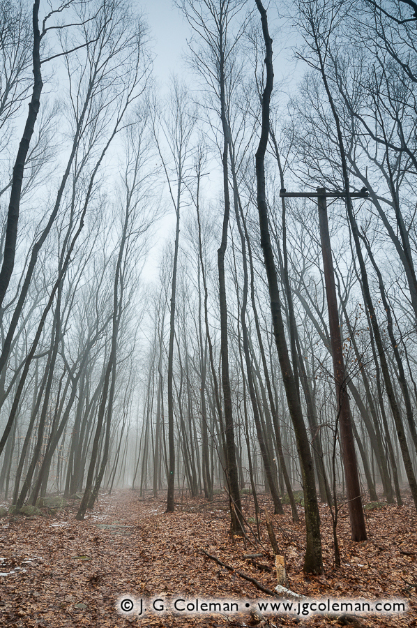
Surely, the most perplexing discovery of the day came as I walked through the forest along the Raptor Woods Trail in the northeastern corner of the Center. At one point I came to a straight-away where I could peer into the distance to see the unswerving stretch of trail ahead, flanked on both sides by a seemingly endless expanse of trees, each reaching longingly towards the featureless sky. But as I looked up at the bare crowns above, I was suddenly drawn to a peculiar horizontal shape amidst an otherwise vertical pattern of tree trunks. Right beside me, in the middle of the woods, stood a telephone pole (photo at right).
As I walked onwards, I realized that there were actually several telephone poles along this trail, each one evenly spaced from the next just as they would be along a suburban street. None of them were strung with wires, so I knew that they had been decommissioned, but I couldn’t begin to imagine how or why these telephone poles had come to be intermingled amongst trees almost twice as tall.
My curiosity was insatiable, so after I made it back to the trailhead and off-loaded my camera gear at the car, I decided to check out the visitor center. The building has a rather interesting design, whereby the interior space is basically circular with various exhibits around the perimeter and the main visitor center desk in the center. On this particular day, an older man (I regret that I didn’t catch his name) was manning the desk and I decided to see if he could shed some light on the peculiar telephone poles in the forest. “Oh, yes,” he explained,” that used to be an old access road for a missile base.”
Ah ha! Suddenly it all made sense. During a previous outing in the summer of 2012, I had hiked to the summit of Pinnacle Rock in Plainville, where one can still see the old concrete pads from a long-decommissioned Nike missile base. As it turns out, the telephone poles along the trail at the Nature Center are remnants of the control site access road for a similar installation dubbed “BR-04”, a missile base in Ansonia which was built in the mid-1950s to protect Bridgeport from the threat of bomber attacks.
For those of you that are scratching your heads over all this talk about missiles, here’s the abbreviated history. With the advent of the Cold War in the 1950s, there was concern that the most important cities and military bases in the United States were woefully susceptible to nuclear attacks by Soviet bombers. In response, the US government built anti-aircraft missile installations in strategic areas around each location with the goal of shooting bombers out of the sky before they could drop nuclear warheads. The installation in Ansonia was just one of a dozen sites in Connecticut that were tasked with defending Bridgeport and Hartford. Yet, for all of the effort and expense of building these installations, most of them were decommissioned less than a decade after they were built. By the late 1960s, the facility in Ansonia was one of only three sites that remained operational in Connecticut. All of these remaining sites were finally shut down in 1971. It’s not entirely clear why the old telephone poles along the access road in Ansonia were never taken down, but they make for a fascinating addition to the Raptor Woods Trail.
I’m always scouting new landscapes, trying to seek out and familiarize myself with places that are uniquely photographic. Inevitably, I return home some days having found nothing of particular interest, so I had no idea what I might discover when I set out for the Copper City on a misty day in January. But within only 150 acres at the Ansonia Nature Center, I was treated to a lively blend of woods and waters where tangible memories of years past lay concealed beneath the forest canopy. The dense suburbs of Ansonia are never more than a mile or two away from even the most secluded trails at the Nature Center, yet the forests here somehow manage to feel wild, remote and timeless.
This is a phenomenon I’ve come across often during the course of producing my landscape photography. The population density of the Nutmeg State is one of the highest in the nation, so in most places, open space is going to be measured in acres rather than square miles. Yet, in several populous areas across Connecticut, there are surprisingly “wild” pockets of land nestled skillfully into areas that are otherwise overwhelmingly tame. The Ansonia Nature Center is a shining example of a natural oasis amidst suburbia, but no matter where you live in the state, you’ll surely be able to find a refreshing piece of the natural world that is astonishingly close to home.
Purchase a Fine Art Print or Inquire About Licensing
My new piece, “The Falls of Burlington”, features a stretch of exquisite cascades along Bunnell Brook which churn ceaselessly over rock outcroppings beneath the shade of a dense forest canopy. If we follow the wispy whitewater upstream, through a jagged rock gorge softened by carpets of moss, we catch a glimpse of early morning light as it sets leaves aglow on the distant horizon.
While these falls have long been known to a handful of locals in Burlington and adjacent towns, it would seem that they never received any official name and you won’t have any luck finding them on a typical map. Instead, they’ve remained a sparsely-visited gem known simply as “The Falls”. The writers of the Burlington Rambler’s Guide, a sort of source book for the natural sights of Burlington, referred to them a bit more precisely as Burlington Falls, though they noted that “we’re not sure if that’s the official name.” So although there may be some measure of confusion over exactly what they ought to be called, Burlington Falls certainly imparts a clarity that can only come from spending time in the woodlands serenaded by the sounds of rushing water.
Perhaps the most striking characteristic of the New England landscape is the dramatic way in which it is forever being transformed by seasonal rhythms. During the summertime, I find myself walking through thick forests that seem virtually tropical in their abundance of crowded greenery. Yet only months later, I revisit the same forest to find a drastically altered landscape. Lively greens have been replaced instead with an earthy mosaic of grey and brown tree trunks that emerge from a white blanket of snow and reach skywards with bare branches. In between these two extremes are myriad transitional states that blend into a seamless cycle of change. So although I am always seeking to imbue my landscape photography with what I call “a sense of place”, I am mindful of the fact that these places are in perpetual transition and can be surprisingly difficult to pin down.
In the spirit of seasonal transition, I will introduce you to my latest fine art prints in a chronology that follows the landscapes of Connecticut from the last days of Summer through the changing of the leaves during Autumn, culminating in the frozen landscapes of deep winter.
Early September on the Connecticut Coast Westbrook, Connecticut
In Southern New England, the early days of September find summertime in its final throws, with temperatures still just about warm enough for a comfortable walk along the beach. My new piece, “Seaside at West Beach” (below), foreshadows the dynamic and temperamental side of nature, qualities which become even more evident as the days pass and early September transitions into early Autumn.
“Seaside at West Beach” brings us to the shores of Westbrook, Connecticut where gentle waves engulf the shell of a long-perished clam. The entire scene possesses a certain surreal quality, owing largely to the way in which sunlight had managed to momentarily struggle through the dark clouds of a passing thunderstorm.
The shell in the foreground is that of a soft-shell clam, known colloquially as the “steamer”. These are rather common mollusks in Westbrook Harbor, thriving in the silty intertidal zone beside razor clams and quahogs. Some of my fondest childhood memories of the Connecticut coast involve digging for these clams on the sandbars in the very place where I produced “Seaside at West Beach.
Late September in the Farmington River Valley Peoples State Forest, Barkhamsted, Connecticut
With late September comes the first days of Autumn, and while it may be too early for the leaves to have started showing their fall colors, there are other indicators of the changing season. Local agricultural fairs are in full-swing all over Connecticut, even though the agricultural way of life has all but disappeared from much of the state. Connecticut farms began to decline sharply in number during the later half of the 19th-century, but aerial photography of the state from the 1930s reveals a landscape that was still heavily quilted with angular cropland in all but the most developed areas. Today, only a tiny fraction of those farms remain. Over the course of the last 80 years, most of them were subdivided to build neighborhoods or abandoned to become forest. Agricultural fairs are one of the last lingering cultural influences from a time when farmland was still a common sight in just about any Connecticut town. Late September is also the time when I usually head to the local orchard for a taste of real apple cider, a drink which has always been part of my “autumn ritual”, for it seems that it embodies the quintessential character of New England.
Yet another sign of the changing seasons is evident while I’m out on photo shoots. During the months of July and August, for example, I can hike comfortably through the wilds of Connecticut with little more than a t-shirt and jeans. Late September is a different story altogether, for although daytime temperatures may still be fairly mild, there’s an unmistakeable chill in the air when I’m hiking out to my destinations in the pre-dawn hours. Such was the case when I scrambled down the banks of the Farmington River in Barkhamsted, Connecticut to compose “Barkhamsted Rapids” (above).
Finding myself woefully under-dressed for the cool air of the river valley, I was shivering as I set up my tripod in the morning twilight. When the Sun finally began to rise behind me, illuminating the trees on the opposite side of the river, I could almost immediately feel a reassuring warmth permeate my body. I shot “Barkhamsted Rapids” only 15 or 20 minutes later, just as the sun had risen high enough to completely set the trees aglow, but while it was still low enough in the sky that the river itself remained bathed in cold shadows. The result is a piece that exhibits a strong contrast between light and dark… between warm and cool… between the summer months that are being left behind, and autumn months that lie in wait.
October Arrives in the Naugatuck Valley Black Rock State Park, Watertown, Connecticut
Even if September doesn’t show many signs of the changing season, October is sure to usher in the full momentum of autumn. Perhaps the most ubiquitous indicator of fall is the changing colors of the woodlands, when summertime forests transform into a brilliant display of reds, purples, oranges and yellows. Each year, Connecticut’s fall colors arrive at their own pace, governed by a mysterious blend of shortened days and varying patterns of temperature, humidity and precipitation. In many cases, these factors can differ starkly from one location to the next, so that the leaves in one forest may have started changing by mid-September, while the leaves in a forest only a few miles away might be held over until early October.
But by mid-October, about the time I ventured to Black Rock Pond in Watertown, Connecticut to produce “Mattatuck Mist” (below), the color change had hit nearly every region of the Nutmeg State. In many places, leaves were already beginning to drop from their branches by the millions.
In “Mattatuck Mist”, we find subtle cues that plant us firmly in the later days of October, such as the strands of reeds that delicately poke through a vivid mosaic of fallen maple and oak leaves which have settled in the shallows of Black Rock Pond. As our eyes travel through this piece, however, we enter an ethereal waterscape bathed in lingering mist, where the forms of towering evergreens crowd the pond and fade to hazy outlines in the distance.
Historically, the name Mattatuck was of Native American origin and referred to a vast swath of land in western Connecticut that we know today as the Central Naugatuck River Valley. When the English settled the region in the mid-1670s, they were content to continue using the term. But when the settlement of Mattatuck was officially incorporated as a town of the Connecticut Colony in 1686, it was decided that the place would be renamed “Waterbury” in light of the many streams and brooks that ran through the territory and emptied into the Naugatuck River.
November in the Connecticut Valley River Highlands State Park, Cromwell, Connecticut
As we move into November, the landscapes of Southern New England have already largely been transformed by progressively cooler temperatures and noticeably shortened days. The dramatic colors of autumn have run their course, and even though the season doesn’t technically give way to winter until the later half of December, the bare trees seem to have already thrown in the towel.
But when I stepped out upon the muddy banks of the Connecticut River on a brisk November morning, I found skies washed over with soft colors and broad, glowing clouds stretching from the horizon. My piece from that morning, “A Cold Day on the Connecticut”, is a testament to the inspiring displays of color that can be had even after the blazes of autumn have come and gone.
This particular stretch of the Connecticut is flanked to the west by River Highlands State Park, a swath of forested bluffs encompassing over 170 acres in Cromwell, Connecticut and rising as high as 150 feet above the river below. Incorporated into the state park system in 2001, “River Highlands” seemed a fitting title given the geography of the area. But if officials had been guided by historical precedent, we might know it today by a much different name!
Back when sailing ships were still a common sight along the Connecticut, this section of the river was termed “the Blow Hole”, owing to the unusually swift winds that pushed through the bluffs and gave passing vessels a brief boost of speed. But traditional lore, perhaps dating back as far as the 17th-century, suggests that the unusual name originated with some of the first generations of Connecticut settlers. Colonial-era Puritans are said to have named the area “The Devil’s Blowhole” on account of the ominous howls that were occasionally heard emanating from the bluffs. In all likelihood, they were simply hearing the wind whistle as it whipped through the terrain.
Despite centuries of precedent, state officials felt that “Blow Hole State Park” would sound downright silly and they ultimately decided against it. Thus, River Highlands State Park was born.
Early January on the Shepaug River Hidden Valley Preserve, Washington, Connecticut
By the time New Englanders find themselves in the thick of winter, the warm and lively landscapes of summertime seem impossibly distant. In Connecticut, daytime highs average in the 30s for a full three months, with cold nights oftentimes bringing single digits. The days are several hours shorter than they were in times of warmth and, in heavily-wooded areas, it seems as if the Sun struggles just to crest over the treetops. Yet, despite the ever-present cold and darkness, there’s a subtle beauty to be found in snow-covered landscapes and a certain introspective quiet engulfs the wildlands. My new piece, “Winter Bliss and River Ice”, is an intimate expression of these unique wintertime qualities.
“Grand landscapes” -that is, photographs that present a wide, sweeping view of nature- figure prominently in my work, but occasionally the most poignant image is to be had by focusing instead upon smaller details. In the case of “Winter Bliss and River Ice”, taken in January, I found these intricate expressions of winter along the banks of the Shepaug River in Washington, Connecticut. During prior cold spells, sheets of thick ice had formed on small boulders in the shallows. The rushing waters of the river carved these icy crowns into marvelously organic shapes and a light dusting of snow transformed them into soft, white sculptures. But what really breathes life into these otherwise monochrome patterns of snow and ice is the vivid yellow reflection of the morning Sun as it kissed the cold waters of the Shepaug in the first few minutes of dawn.
Photographing Connecticut’s wildlands in the dead of winter is no easy task. “Winter Bliss and River Ice”, for example, demanded a slow, laborious trek along the Shepaug on snowshoes. Three layers of clothing shielded me from the frigid air that pooled in the valley overnight. Dim morning twilight did little to illuminate the snow-covered trails, cloaked as they were in the cold shadows of hemlocks.
And yet, when a shot comes together just right, the challenges of the terrain and the hardships of the climate are effortlessly forgotten. For a brief moment in time, it’s as if all of the world is being channeled through the viewfinder. In these moments, it makes little difference if I’m at the summit of a mountain, in the crowded forests of a river valley, knee-deep in a bog or surrounded by sprawling meadows. My mind doesn’t wander to the rain or the heat or the snow. These moments somehow seem to swallow me up entirely, so that when the shutter slaps shut on the final exposure and I step back from the camera, it’s as if I’ve all of the sudden returned to my body from someplace else entirely. A true “sense of place” is born of these moments; they are nourished by every season, they are the fruit that nature bears year-round.
Tolstoy wrote that “one of the first conditions of happiness is that the link between Man and Nature shall not be broken”. It is my hope that the visions of the American Northeast that I create might strengthen, if not renew, that link. I wish all of my viewers a bountiful new year in 2013 and I look forward to bringing you fresh, new work from the field in the coming months.
Connecticut’s Northwest Hills, encompassing roughly 1,000 square miles and 20 municipalities, are oftentimes thought of as the “the backcountry” of the Nutmeg State. These highlands are largely a rough and mountainous terrain, deeply-furrowed with valleys and river gorges that cut between several of the highest summits in the state. Conspicuously avoided by Connecticut’s major highways, the region is largely traversed by winding, woodland backroads. It is perennially colder here than the rest of the state, usually receiving the most snow and being the last area of Connecticut to see that snow melt away in the Spring. The population density is unusually low at only about 140 people per square mile, fully five times more sparse than that of Connecticut as a whole.
Even if Connecticut’s “frontier days” came and went centuries ago, the Northwest Hills are nonetheless host to lost vestiges of that bygone era; places that feel as if they were somehow left behind as time pushed forward. My latest work from this corner of the state illustrates just a couple of the enchanting landscapes that draw me back time and time again whenever I am moved to head northwest, out of the population centers of the Connecticut River Valley and into these rural wilds.
White Memorial Conservation Center Litchfield, Connecticut
In my piece, “Ethereal Passage”, a seemingly endless boardwalk invites us to wander into a twilight dreamscape of lush wetland foliage. As we follow the dimly-lit pathway, we all but lose ourselves in mist-laden forest silhouettes beneath a sky painted with delicate wisps of clouds that foreshadow the approaching dawn.
Despite the surreality of “Ethereal Passage”, it portrays a place which is very real, indeed. These wetlands lie on the fringes of Little Pond, a small body of water within the vast 4,000-acre White Memorial Conservation Center in Litchfield, Connecticut. Encompassing more land than even the largest of Connecticut’s state parks, the White Memorial Conservation Center is a most impressive effort in the preservation and management of the wilds of the Northwest Hills. A varied array of plant and animal life flourish within the Center’s six square miles of forest, rivers and ponds, open fields, wet meadows, swamps and vernal pools.
The origins of the White Memorial Conservation Center revolve around Alain White, a wealthy man whose dedication to preserving natural places began in the early 1900s and ultimately saw him becoming one of the most influential figures ever to exist in the history of Connecticut conservation efforts. The story begins at the banks of Bantam Lake in Litchfield in 1908, where Alain is said to have had something of an epiphany while fishing with a good friend amidst the quiet countryside. As if all of the sudden realizing his life’s mission, he commented that it would be grand if the landscape could remain in its peaceful and largely-undeveloped condition well into the future.
In that day in age, the idea of setting aside land to be protected from development was still relatively new; many industrious Americans insisted that the practice was as preposterous as it was wasteful. And, if he was so inclined, Alain could’ve simply shrugged off his passing idea, finished his day of fishing, and gone about his life no different than before. But, as unlikely as it may seem, that fleeting thought seized upon his consciousness and blossomed into a far-reaching campaign of preservation. In total, Alain and his White Memorial Foundation contributed nearly 6,000 acres of open space to the State of Connecticut, mostly for inclusion in state parks and state forests throughout Connecticut’s Northwest Hills.
Roughly 4,000 additional acres of land, comprising the White Memorial Conservation Center in Litchfield, now surround Bantam Lake… the very place where, little more than a century ago, Alain White sat patiently with his fishing rod waiting for a bite, entertaining the lofty idea that there was something inherently important in ensuring that future generations could find peace in places of nature. Certainly, he drew from the same deep intuition as the great John Muir, who wrote that “everybody needs beauty as well as bread, places to play in and pray in, where nature may heal and give strength to body and soul.”
And with that, I introduce to you another of my new works from the White Memorial Conservation Center: “Bantam River Quietude”. In this work, we overlook the calm waters of the Bantam River as they depart from Little Pond on their way towards nearby Bantam Lake. Mirror-smooth water reflects the soft colors from above so strongly that it is almost as if the Bantam River is fed by the sky itself. Only the wetlands, alive with pickerelweed and grasses and softened by a lingering mist, frame the the scene and provide orientation.
“Bantam River Quietude” is an expression of simplicity and serenity; an attempt to access that state of peaceful contemplation that Alain White found on that fateful day beside Bantam Lake.
Housatonic River Kent, Connecticut
Our next stop in the Northwest Hills brings us to the banks of the scenic Housatonic River, specifically that stretch which cuts through the old Bulls Bridge section of Kent. In 1897, Francis Atwater wrote in his book, History of Kent, Connecticut, that “the lover of the beautiful can see something fortunate in the circumstances which protected Bulls Bridge from the roar of the great world and left it sequestered and almost as picturesque as in its pristine days before the white man came and made his wide clearings.” According to Atwater, the railroad never quite made its way to Bulls Bridge. So, while so many previously small towns in Connecticut began to blossom into small cities with the advent of the rail in the mid-1800s, Bulls Bridge seemed to have been left behind.
Although Atwater wrote those words over a century ago, little has changed in the interim. Even as the importance of the railroads began to atrophy with the popularity of personal automobiles, Kent has continued to remain mostly rural and sparsely-populated. And, indeed, we can still see “something fortunate” in the sheer breadth of natural beauty that has been spared within Kent.
Take my new piece, “Housatonic Summer”, for instance. Here we are treated to a view of the boulder-laden Housatonic River as it furiously cascades southwards on its journey towards Long Island Sound, still some 40 miles away. The dense forest which crowds the riverbanks glows with vitality in the potent sunlight of late-morning. High above, the airy clouds against a bold blue sky top it all off. “Housatonic Summer” is more than just a journey into this riverscape of the Northwest Hills: it is a celebration of those perfect summer days that we’ve all come to love, no matter where we may live.
But this particular stretch of the Housatonic is rather unique for a few reasons. Only a few hundred feet downstream from this vista is Bulls Bridge, one of Connecticut’s only two remaining covered bridges that are still used by traffic. One might guess that the old village of Bulls Bridge was named after this bridge, but the exact opposite is the case. For roughly 250 years, the Bulls Bridge area of Kent was simply a well-known locale where the Housatonic River could be crossed. There were at least a few different bridges built there, beginning with one purportedly constructed by the Bull family, which ran an ironworks closeby in the mid-1700s. The wooden bridges of those early days didn’t have nearly the longevity of modern bridges, so as one wore out another would be built. It’s not clear exactly how many different bridges spanned the Housatonic in Bulls Bridge over the centuries, but the current version was not constructed until the mid-1800s. Spanning a distance of more than 100′ across the river, the bridge eventually received modern metal underpinnings which have strengthened it enough to allow a single lane of traffic to pass through on a daily basis.
Perhaps even more impressive are the gaping, smooth-bored holes in the limestone outcroppings that flank the western side of the river beneath the bridge and extend about 300 feet upstream. Known as “giant’s kettles” or “giant’s cauldrons” (or occasionally just termed “potholes”), these deep pits are the result of abrasive detritus like sand and stones getting caught in depressions in the bedrock floor of the river. As eddies in the water swirl them around and around, they gradually grind more deeply into the depression. Over the course of hundreds or thousands of years, this gradual grinding action can carve some surprisingly deep pits in solid stone.
One of these cauldrons is prominently featured in my new piece, “Giant’s Kettle on the Housatonic”. Producing this photograph required a good deal of planning and patience in order to fulfill my vision for the the shot. While I knew that I wanted to highlight one of these remarkable limestone rock formations, I needed to find a perspective from which I could capture all the elements that come together to make this stretch of the Housatonic such a captivating place. After scrambling some distance upon the pock-marked riverside bedrock, I came to the kettle you see here, which seemed to offer the opportunity I’d been seeking. Something as simple as setting up the tripod was quite challenging, since the only surface available was deeply-pitted limestone. Even once I managed to haphazardly brace the tripod legs, I had to wait over an hour for the perfect lighting conditions: bright enough to illuminate the vicious currents of the Housatonic that carved these kettles, but also subtle enough that I could simultaneously capture detail within the smooth, shadowy kettle in the foreground, where foamy water still endlessly swirls away, grinding an ever-deepening cauldron in the stone. All of the time and effort certainly paid off though, for in creating “Giant’s Kettle on the Housantonic”, I was able to swallow up the full magnificence of this grand riverscape.
Want to See More of Connecticut’s Northwest Hills?
There’s little doubt that the Northwest Hills of Connecticut figure quite prominently in my work; acre for acre, I find them to be some of the most wild and picturesque places in the state. Several of the most stunning landscapes in this region are featured in my artwork, so I’ve listed some collections below that will bring you ever deeper into this magical corner of Connecticut. Also, be sure to check out two of my previous posts —”Rivers & Streams Emerging from Winter” and “Car Troubles on the Way to Kent“— both of which discuss Kent Falls (located in Kent, only about 10 miles northeast of Bulls Bridge).
Kent Falls is probably Connecticut’s most well-known and scenic set of waterfalls. I’ve spent more time here than almost any other individual park in the Northwest Hills, capturing views of the remarkable limestone cascades and the wonderful transformations that occur with each season.
Located mostly in Norfolk, this is the only Connecticut state park which is not entirely located within the state’s borders. The northern tip of the park juts into Massachusetts, which jointly owns and maintains the park.
Encompassing some of Connecticut’s oldest hemlock and white pines, the old-growth forest of Cathedral Pines Preserve in Cornwall has recently been dubbed a National Natural Landmark by the federal government.
These three nature preserves, all located within Washington, Connecticut and owned by the Steep Rock Association, are amongst some of the most beautiful open spaces in the state.
Located in the rough woodlands of Roxbury, Connecticut, Mine Hill was once the site of a 19th-century ironworks, not unlike those that operated all over the Northwest Hills in those days. The roasting ovens and iron furnace still stand eerily amidst the forest, even though the area is now a scenic nature preserve.
If you’ve read any number of my posts here on From the Field, you probably know that I get a bit nostalgic when it comes to thoughts of the “old days” of Connecticut. You know, the days before the railroads came through, before industry completely transformed the previous two centuries of ever-steady Yankee lifestyle; the days when the state was still a bucolic patchwork of small, quiet towns connected by rough carriage roads. While I’m well-aware that it’s dangerously easy to idealize those bygone days, overlooking the many hardships and inequalities that people of that era faced, I still find something deeply comforting in the thought of a time in Connecticut’s history when daily life didn’t move at the breakneck speeds to which we’ve become accustomed in modern times.
In the 1830s, the population density of Connecticut is estimated to have been only about 60 people per square mile, a far cry from the staggering 750 people per square mile that inhabit the state today. It is presently one of the most densely-populated states in the nation, coming in at fourth place behind New Jersey, Rhode Island and Massachusetts. Indeed, things have certainly changed over the last few centuries. But perhaps a visit to Northern New England gives us a faint taste of what the Nutmeg State might’ve been like 200 years ago.
Fair Haven, Vermont
Take, for example, my new piece titled “Bird Mountain Countryside”, which brings us to Fair Haven, Vermont. Here we are treated to a broad expanse of meadows and pastures that lead our eyes towards the horizon where the monolithic slopes of Bird Mountain rise from a thick blanket of early-morning fog.
The lands of Vermont seem practically deserted in comparison to most places in Connecticut. In fact, the population density of the “Green Mountain State” is less than 80 people per square mile in modern times, rather close to the figure reported for Connecticut so long ago during the pre-railroad era.
After I finished developing this piece, I took a proverbial “step back” and found that it faintly reminded me of the 1849 painting of New Haven’s West Rock Ridge by Frederic Edwin Church, a 19th-century Connecticut-born artist. I won’t indulge in likening myself to this master of the Hudson River School, but I mention Church’s painting because, like my “Bird Mountain Countryside”, it portrays a classic, bucolic foreground coming to a certain crescendo at a prominent mountain in the distance. "West Rock, New Haven" (1849) Painted by Frederic Edwin Church
The big difference here is that my perspective of Fair Haven is current; if you were to stand exactly where I produced this photograph, you’d see the same fields, pastures and meadows. In contrast, Church’s idyllic agrarian New Haven has long ago vanished beneath increased urbanization and, especially, the concomitant phenomenon of suburban sprawl along city margins. In fact, the Hudson River School painters were known to “idealize” the otherwise real landscapes that they painted… so it’s tough to say if Church’s New Haven of 1849 actually even existed as he painted it. Maybe it did, but maybe there’s a measure of fiction blended into his portrayal. We may never really know for sure…
Ultimately, the point remains that what Church was trying to express in his “West Rock” -that is, an image of an agrarian society peacefully co-existing with nature- isn’t far from the reality that exists in modern times at the foot of Bird Mountain. Perhaps it is that the character of “Old Connecticut” is in some sense still alive within the valleys of the Green Mountains.
Killington, Vermont
Our next few destinations on this odyssey are within the town of Killington, Vermont… a place which is undoubtedly famous among Northeastern skiing enthusiasts. However, my latest works from Killington were produced in the warm, humid months of summer… long after the snow drifts had vanished. Indeed, the side of Killington I want to show you is little-known to those who arrive for a few days in the dead of winter and never leave the vicinity of the resort. If we venture elsewhere within the 46 square miles of territory the town encompasses, we find some rather beautiful places that lay off the beaten path.
“Mirror of the Shrouded Hills” (below), my new piece from Killington’s Kent Pond, features one of those scenic treasures. Here we find ourselves overlooking a landscape crowned by thickly-wooded hills and steeped in heavy blankets of lingering mist. Below, the hills are cast from the surface of Kent Pond as a soft reflection, out of which emerges the shadowy silhouette of a small, rocky island populated by only a few lonely conifers seemingly marooned from the surrounding forests.
What originally drew me to Kent Pond, though, was the outlet brook that departs from the body of water on its eastern shores. Some official maps call this stream “Kent Brook”, a name which is as sensible as it is unremarkable. Unofficially, this brook enjoys a much more interesting title: “Thundering Brook”. At the risk of exposing my childishly-excitable side, I will admit that any river called “Thundering Brook” is a river that I simply must see for myself.
My fine art piece, “Green Mountain Riverscape”, portrays a conifer-crowded glade scattered with boulders where Thundering Brook topples over tiers of terraced bedrock before disappearing some distance downhill. This piece was especially gratifying to produce, as I feel that I was able to faithfully capture the very wild and untamed aura that permeates the landscape surrounding the rugged watercourse of Thundering Brook.
“Green Mountain Riverscape” is, in a sense, a timeless vision of Vermont’s natural places, freed of any strict associations with modern times. As I look at the piece I wonder,” Could Thundering Brook really have looked much different 100 years ago? Or 200 years ago? Even 1,000 years ago?” Ordinarily, I dive deeply into the history of the landscapes that I photograph, for I feel strongly that understanding the history of a place brings me closer to its essence. But occasionally I am moved to forgo this craving for knowledge. This vista on Thundering Brook is not far from a well-packed dirt road… beside the brook runs a small-diameter pipeline of indeterminate use… and beside portions of the brook, the banks are well-packed by frequent visitors. But for all of these reminders of the modern world that surround Thundering Brook, there were inevitably instances in which I gazed in just the right direction from just the right perspective and, all of the sudden, it was as if I was looking not only at a river that receded into the distance, but also at a scene that receded deep into the past… so deeply that, for a brief moment, it was as if all the pesky considerations and attachments to clock and calendar, which are so much a part of our modern lives, vanished amongst the cacophony of cascades and waterfalls.
The calming waters of Thundering Brook, as they are seen in “Green Mountain Riverscape”, may not appear to be as furious… as violent… as “thundering”… as one might expect. I’ll admit that Thundering Brook was not exactly a roaring torrent on the day that I visited, a condition that I attribute mostly to the peculiar dry spell that dominated most of New England’s summer season. Every brook I visited this year, from Southern Connecticut to Central Vermont to Eastern New York, was generally at quite a reduced water volume. But given the circumstances, Thundering Brook still had a decent volume of water flowing; I can only imagine that it truly thunders during the springtime, angrily crashing through the forests of Killington as it hauls away meltwater. One source* states that Thundering Brook carries less than 10 cubic feet of water per second (cfs) in the summertime, but notes that “peak events” have seen that figure swell to a staggering volume of just under 800 cfs! Can you imagine the near-cataclysmic power being channeled through this brook?
But even if Thundering Brook was lacking the water volume required to truly live up to its name, the impressive waterfalls along its course were still quite spectacular. “Thundering Brook Falls”, a series of roughly three big drops along the course of Thundering Brook, were the first landmarks that really sparked my interest to conduct a shoot in Killington.
My new piece, “Parallel Worlds”, features the final and tallest waterfall of the bunch. What I found especially intriguing about the views of this 60-foot waterfall was the unusual contrast between the forest and the watercourse. Owing to the green-tinted light filtering through the coniferous canopy, the entire forest in the upper portion of the frame is steeped in warm color tones and the underlying rock is softened by lush carpets of moss. Yet, at the foot of the woodlands we find Thundering Brook Falls cascading over slopes of barren bedrock, jagged and angular and glistening with subtle reflections of the sky above. “Parallel Worlds” leverages this intriguing disparity, inviting us to simultaneously accept nature as both vital and desolate… a source of nurture and a force of hardship. Through the lens of civilization, nature seems to express itself alternately as the giver and taker. There on Thundering Brook Falls, though, these parallel worlds blended seamlessly into a landscape that tapped a more primeval vein of my unconscious. And as I sat by the gorge in the humid early-morning air, the Sun triumphantly breaking through the clouds and casting bright beams upon the woodlands, I was reminded of the words of John Muir: “The clearest way into the Universe is through a forest wilderness.”
To see larger versions of the Vermont landscapes pictured here, simply click on any of the photographs above and you’ll be brought to my online gallery.
To see all of my landscape work from Vermont, be sure to visit my Vermont Gallery at JGCOLEMAN.COM.
* Information on water volume was drawn from the profile for Thundering Brook Falls found on Waterfalls of the Northeastern United States, a website authored by Dean Goss. Be sure to check out his page for Thundering Brook Falls.
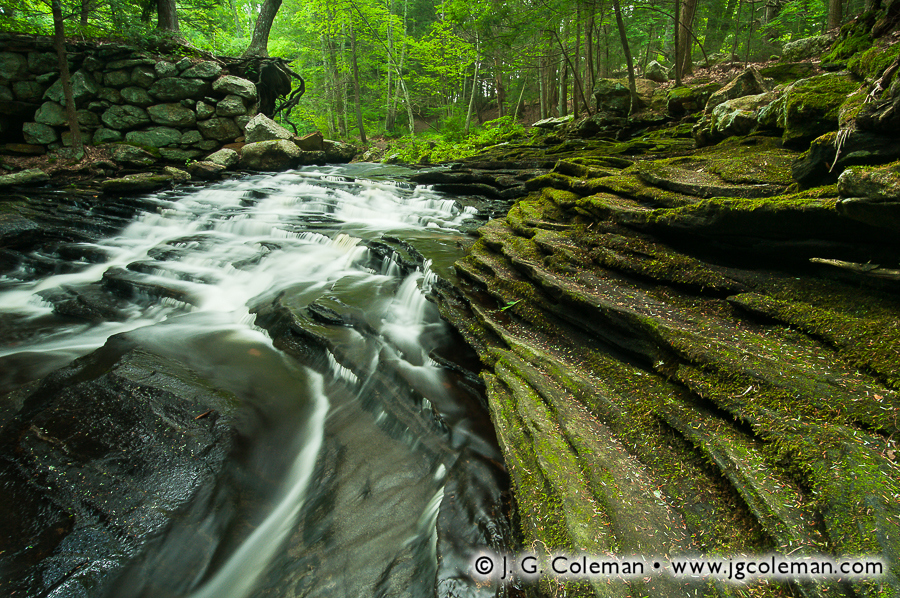
You can be among the first to see J. G. Coleman’s print, “Old Dish Mill Falls on Jim Brook“, a fine-art landscape photograph taken at Roaring Brook Nature Center in Canton, Connecticut. The work will be on display through the month of November at J. Vallee Brunelle Fine Art & Framing in Granby, Connecticut. “Old Dish Mill Falls on Jim Brook” is only one of many works that will be on display for Celebrating Art in Nature, the 2011 Granby Land Trust Annual Juried Art Show.
Celebrating Art in Nature is a small art show that features paintings, drawings, photography and 3D works inspired by nature and landscapes of the Farmington River Valley region. The opening reception for the showing is on Thursday, November 3, 2011 between 5:00 PM and 8:00 PM.
The showing will run from November 3, 2011 through December 1, 2011 and every piece on display is available for purchase. The Granby Land Trust will receive 40% of the proceeds for every work purchased at J. Vallee Brunelle, which will help them continue to preserve Granby’s natural heritage (a portion of those proceeds will also go towards supporting the event).


")