Springtime in the American Northeast was described perfectly by Pennsylvania-born author Henry van Dyke in 1899:
“The first day of spring is one thing, and the first spring day is another. The difference between them is sometimes as great as a month.”
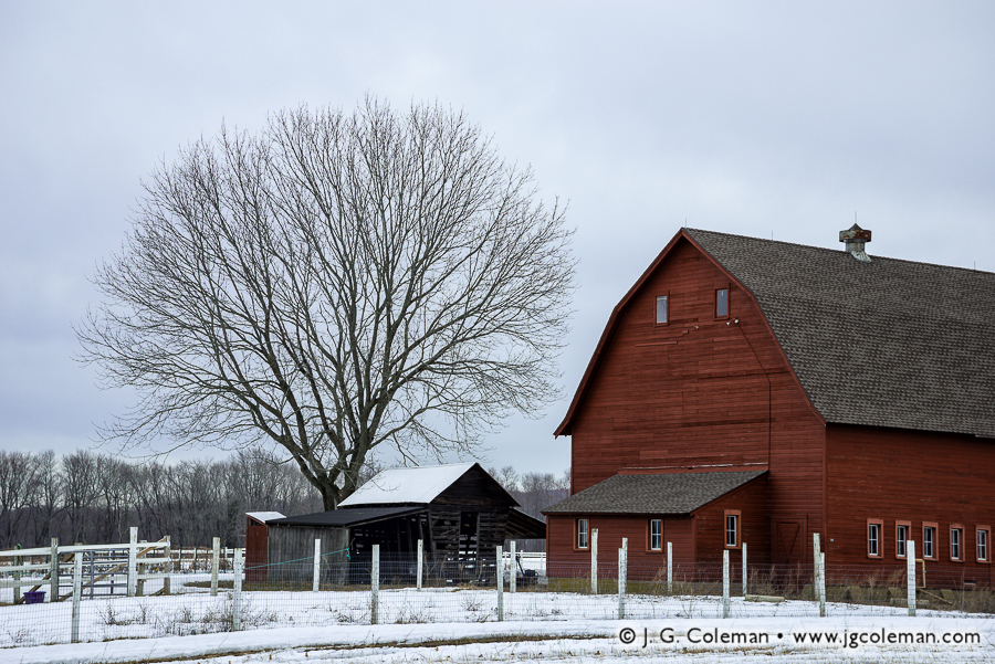
Judging by the stillness in the cold air and the snowpack lingering upon the barnyard of the Glastonbury farm in my new piece, “Yankee Farmlands № 25” (above), it would be tough to tell that a season of renewed warmth is upon us. Then again, fields that were covered a yard-deep in snow just a month ago have since thinned out to less than a foot and we’ve had some forgiving temperatures lately.
This much-awaited break in the winter weather is already presenting some fresh new shooting opportunities. Recent warm spells have melted substantial amounts of snow, causing brooks and rivers all over the state to swell. Waterfalls which have been snow-caked and encrusted with ice since January are finally awakening from their seasonal slumber. The woodlands and farmlands alike are still fairly dormant this early in the year, but as snow vanishes from road shoulders and trailhead parking lots, I’ve been delighted to find that I’ve finally got a place to park my truck again!
I’ve eased my cabin fever over these past couple months by putting together a new list of exciting shooting locations in Southern New England; I’m more than eager to get back out into a lively green landscape! So here’s to another long winter being behind us… and another glorious spring ahead!
Purchase a Fine Art Print or Inquire About Licensing
Be sure to check out my Yankee Farmlands collection, the fruit of an on-going project which celebrates the agricultural heritage of the American Northeast through the breath-taking farmlands of Connecticut.
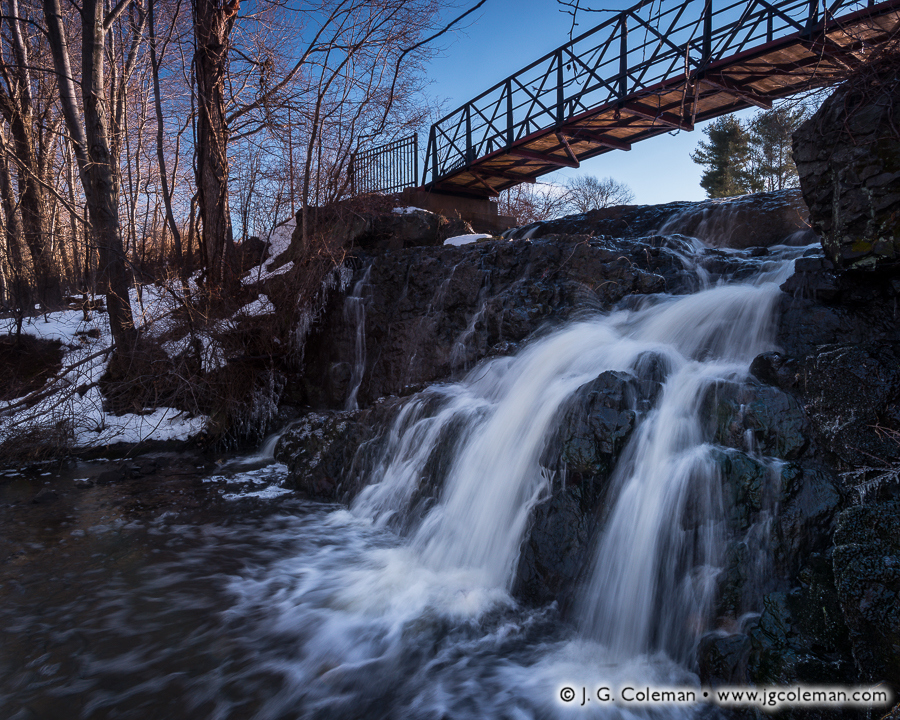
In my new piece, “Heart of the Old Mill”, Mill Pond Falls slips over a shadow-cloaked ledge, its frigid cascades churning to whitewater as it skips over time-worn stone. Above the precipice of the falls, dawn casts warm, sharp light upon a footbridge and snowy woodlands nearby.
Nestled within the center of Newington, Mill Pond Falls is certainly one of Connecticut’s lesser waterfalls at perhaps just 12 to 15 feet in height. Still, the town’s claim that it’s the “smallest natural waterfall in the United States” is no less perplexing.
But while Mill Pond Falls may measure a bit short, it is arguably more beloved than most waterfalls that are several times larger. Each year it is the centerpiece of the “Newington Waterfall Festival” and its cascades are even featured prominently on the town seal! Why so much fanfare over such a diminutive waterfall? During the earliest era of its settlement between the late 1600s and mid-1700s, Newington’s fledging economy was wholly dependent upon these falls to power a local sawmill. So if not for this tiny waterfall, its safe to say that the old colonial village of Newington may have vanished from the map centuries ago.
Purchase a Fine Art Print or Inquire About Licensing
“It is said that time is unrelated to everything else. It goes on and on, unnoticing of our actions, our falls, our triumphs. Who’s to care then, if time does not remember us? It flies by, fleeting, inattentive and disinterested in any occupants of this earth. What are we, then, if time thinks so little of everyone it passes?”
—Alexia Purdy, “Disarming”
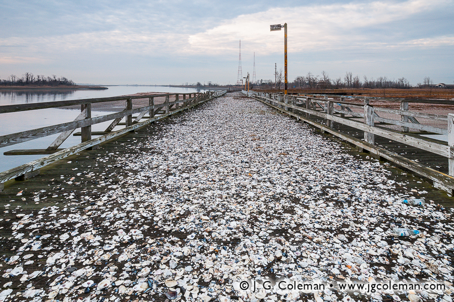
Abandoned places possess a unique allure for those who are receptive to the stories that resonate in the hollows of their vacant buildings and crumbling foundations. Few places in Connecticut so strongly embodied the “post-apocalypse” aesthetic as Pleasure Beach, a deserted amusement park and cottage village which stood vacant for nearly two decades at the end of a two-mile peninsula on Long Island Sound. My newly-released work features the quiet landscapes of this ghost town and seeks out untroubled beauty in a place where the rhythms and sounds of mankind have been extinguished.
Beginning in the late 1890s, Pleasure Beach emerged as a modest amusement park and beach cottage community situated at the end of a long peninsula that extended westward from the coast of Stratford into Bridgeport Harbor. Although it was initially accessible only by ferry, a swing bridge was eventually constructed in the 1920s which connected Pleasure Beach to the coast of Bridgeport and permitted easy access for pedestrians and automobiles alike.
The next five decades proved tumultuous for the amusement park. Throughout the years, it would enjoy periods during which it was wildly successful, only to grow run-down and be sold off when shifts in economy or culture led to declines in attendance. But whenever Pleasure Beach reached the brink of abandonment, it seemed that another owner would step up and take the reins for some number of years. When a fire ripped through the park in the 1950s, its days as a proper amusement park were numbered, but a beer garden, dance pavilion, playhouse and other disparate attractions remained and continued to draw some visitors for another two decades. When the dance pavilion succumbed to fire in the 1970s, and with the rest of the structures beginning to show their age, the 80-year legacy of Pleasure Beach finally came to a close.
For owners of the dozens of cottages adjacent to the defunct amusement park, though, the closure may perhaps have been a welcome source of quietude. After all, they continued to enjoy their seaside properties for another two decades, accessing them via the same old, trusty swing bridge that once serviced Pleasure Beach. But even this lingering human presence would not last. In an all too common scenario for Pleasure Beach, fire engulfed the mid-section of the bridge in 1996, destroying the only road to the cottages. With municipal emergency vehicles no longer able to access the area, the cottagers were evicted. They hauled away whatever of their belongings they could by barge and the entire neighborhood of cottages, alive with summertime joy just a year earlier, quite suddenly became Connecticut’s largest ghost town.
My piece, Dominion of the Gulls, was taken upon the stub of the decaying swing bridge that still extends from Pleasure Beach towards the Bridgeport mainland (the charred mid-section of the bridge was directly behind me). Ever since Pleasure Beach was abandoned almost two decades ago, clever herring gulls have been cracking open clams, oysters and snails by dropping them upon the bridge decking from dozens of feet in the air. Some of my other works above, such as What Remains of the Joy (top) and A Wall Overtaken, portray further ruins such as broken lamp posts and crumbling seawalls which are commonplace along the beaches.
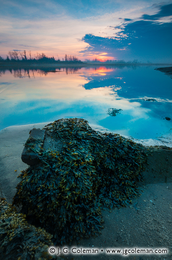
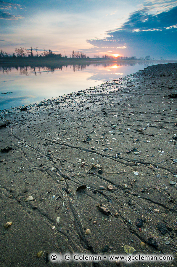
But despite the unfortunate circumstances surrounding the abandonment of Pleasure Beach, there’s no doubt that nearly two decades of isolation from the densely populated mainland has returned this barrier peninsula to a wild state. My pieces, Dawn Over Lewis Gut and Lewis Gut, Tide Withdrawn, celebrate the natural beauty that has persisted at Pleasure Beach even as time and vandalism took its toll upon the structures. For the benefit of the inquisitive, it’s worth mentioning that Lewis Gut is the narrow cove which separates Pleasure Beach and the Long Beach Peninsula from the mainland of Stratford. The term “gut” for a cove or bay always struck me as somewhat odd, though I’ve come to discover that it is in no way without precedent.
For sure, the story of Pleasure Beach could’ve ended with its abandonment in 1996, but both Bridgeport and Stratford have shown renewed interest in the land over recent years. For its own part, Stratford went ahead and demolished the dozens of decaying cottages adjacent to Pleasure Beach back in 2011, eventually selling its stake in the peninsula to the federal government for preservation as valuable breeding habitat for shorebirds. Bridgeport has gone a different direction, reopening the grounds of Pleasure Beach as a town park. In fact, as of June 28, 2014, ferries began shuttling visitors back and forth between the mainland and the newly-constructed dock on the tip of the peninsula.
Between reanimating the peninsula with sounds of summertime joy and setting aside a large swath as conservation land, one could hardly imagine a more positive direction for the latest chapter in the story of Pleasure Beach. That being said, I would be lying if I didn’t admit at least a hint of regret that Connecticut’s most distinctive ghost town —and, for that matter, one of its most peculiar wildland areas— has suddenly become quite a bit more tame and pedestrian. In this day in age, as Connecticut is further developed and quiet, out-of-the-way places seem to be vanishing, the notion of a modern ghost town of any sort existing in the state seems preposterous. For better or worse, civilization in Southern New England abhors a vacuum and one would think that such a large expanse of beachfront property would have been swallowed up by a developer long ago. Indeed, its remarkable that Pleasure Beach persisted so long in its barren state in spite of the hustle and bustle on the nearby mainland. For well over a century, though, Pleasure Beach has been characterized by change and by ever-repeating patterns of renewal and exhaustion. Seeing this place revived from its ruins may be bittersweet in a certain sense, but its a fitting addition to the saga of Pleasure Beach.
For those who are curious, the photographs seen here were produced in March 2014, roughly three months before Pleasure Beach was reopened for the first time in 18 years.
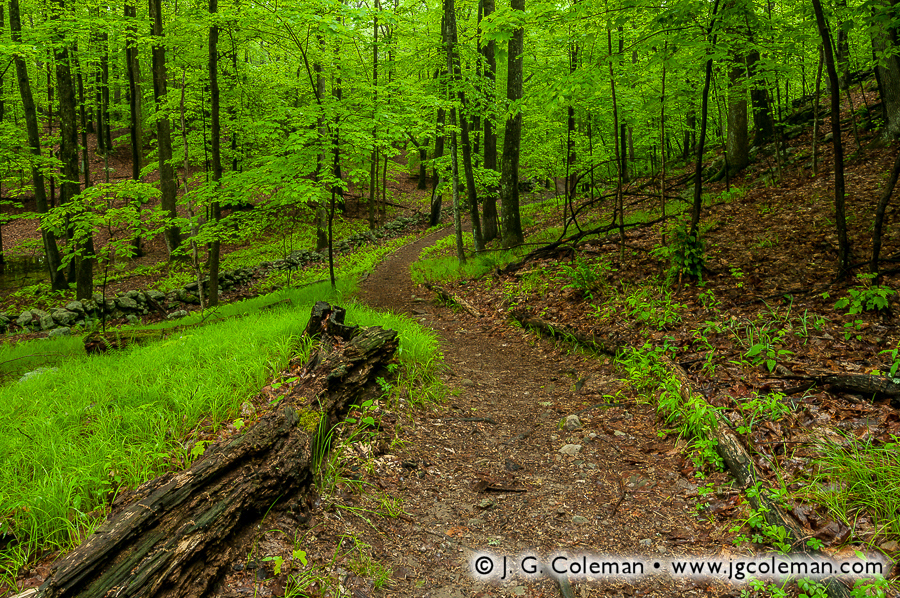
In 1955, its protection became the goal of the very first land project undertaken by The Nature Conservancy. By 1968, it was the first location in the United States to be federally-recognized as a National Natural Landmark by the National Park Service. It is home to towering hemlocks so ancient that they were already a century old when the American Revolution came to a close. But if all of these facts about the Mianus River Gorge Preserve are surprising, perhaps the most unbelievable part is that this 760-acre nature preserve is sprawled out across a handful of suburban towns just 30 miles from the streets of New York City!
My latest work from this unique preserve showcases some of the superb scenery which is characteristic of the wildlands of the American Northeast. In my piece, “Havemeyer Fallscape” (at top), the pristine waters of Havemeyer Brook leap eagerly over a forest-crowded ledge, dodging downed trees and boulders en route to a confluence with the Mianus River.
Among my newer works from this preserve is also “Winding Like the River” (above), which portrays one of the time-worn hiking trails that weaves through the shadowy woodlands just uphill of the Mianus River Gorge. As I walked upon this particular stretch of trail, I realized that slipped through the forest in broad, serpentine bends with much the same grace as the Mianus River itself weaved its own course at the bottom of the gorge nearby.
Want to See More?
Interested in buying a fine art print of the pieces seen here? Visit the landing page for Havemeyer Fallscape or Winding Like the River to see larger versions and explore print options.
My Waterfalls of Connecticut collection is on display during the entire month of July at the Noah Webster Library Gallery in West Hartford, Connecticut.
My Waterfalls of Connecticut collection is on display during the entire month of July at the Noah Webster Library Gallery in West Hartford, Connecticut.
During the month of July, a selection of my prints will be on display at the Noah Webster Library Gallery in West Hartford, Connecticut. The exhibition theme is “Waterfalls of Connecticut” and you’ll enjoy 15 pieces that portray a range of waterfalls from diverse areas of the state. If you haven’t had an opportunity yet to see one of my finished pieces -a framed and matted print- then this your chance to see a wide range of them all in one place in a relaxed and especially quiet venue.
Although waterfalls represent only a portion of my subject matter, there’s little doubt that I have a special affinity for them. Over the course of more than four years, I’ve dedicated considerable time and creative energy to producing photographs that capture the unique sense of place that these waterscapes offer. Earlier this year I released a collection of images, also titled “Waterfalls of Connecticut“, which portrays thirty waterfalls from around the state and celebrates my aesthetic fascination with cascading water.
My Waterfalls of Connecticut exhibition at the West Hartford Library is based upon my earlier collection and incorporates some of the pieces that you may be familiar with already. However, I’ve also included in this showing a number of pieces that were produced in just the past 6 months. For that matter, some of the pieces on display feature waterfalls that weren’t included in the original Waterfalls of Connecticut collection.
So whether or not you’re familiar with my original Waterfalls of Connecticut collection, there’s still plenty to see at this exhibition. In addition, I’ve also hung all three of the pieces from my newest collection, Old Timbered Crossings, which features the last three historic covered bridges left in Connecticut.
Consider yourself invited to visit the Noah Webster Library at any time during the month of July to see my work!
When and Where
Location:
Noah Webster Library
20 South Main Street
West Hartford, CT 06107
Duration:
June 30 – July 31, 2014
Other Info:
The gallery area is located on the main floor. Don’t hesitate to ask the library staff at the front desk.
As part of J. G. Coleman’s Decor Series prints, all of the works seen at the exhibition are available at Fine Art America. You are encouraged to visit J. G. Coleman’s Fine Art America eStore, or see all of Fine Art America’s waterfall art.
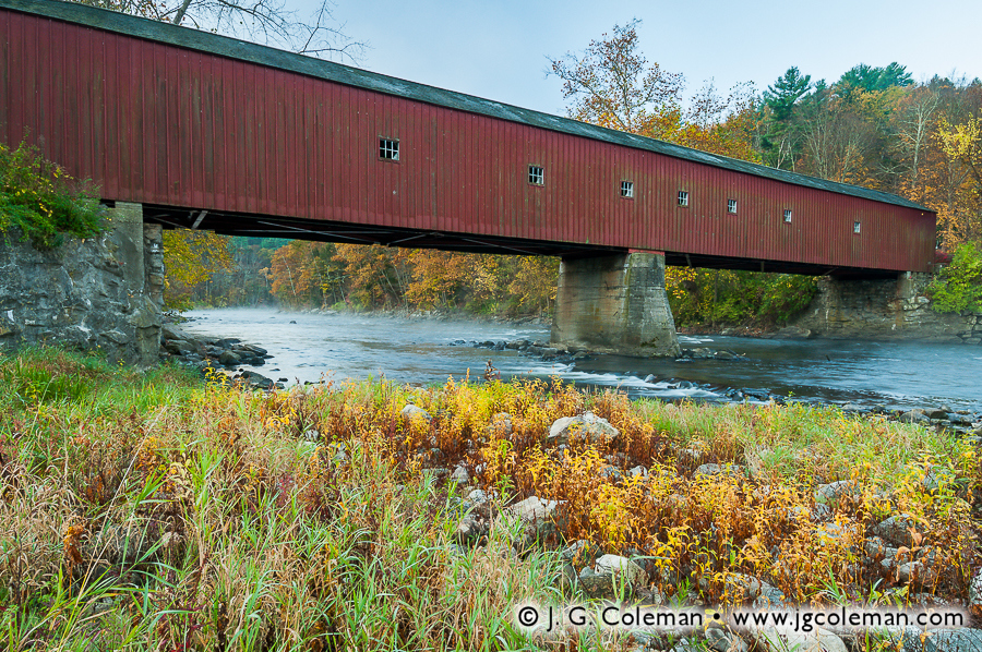
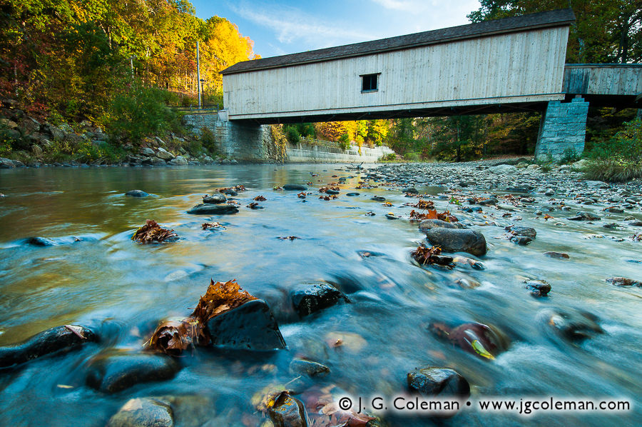
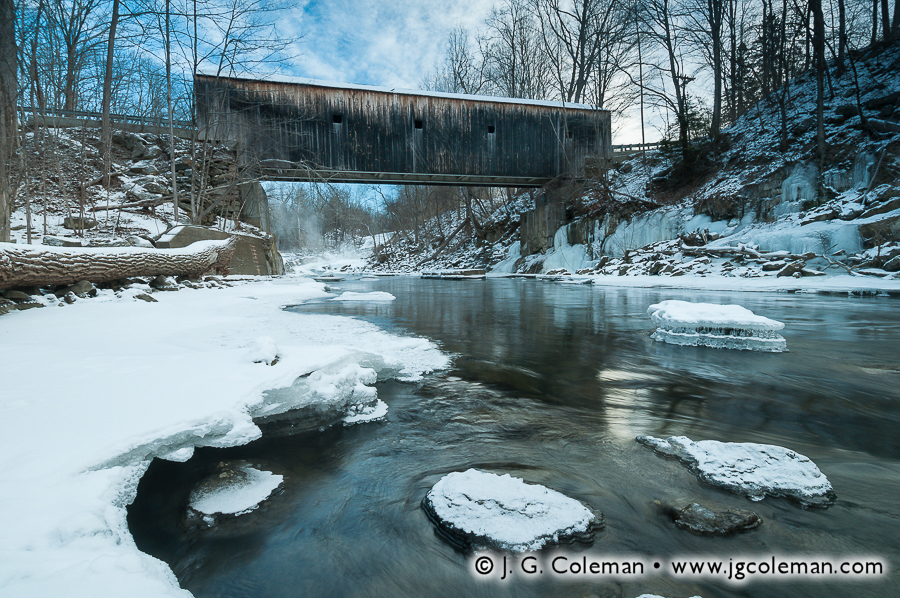
Potent remnants of classic New England are few and far between these days. Thousands of fields abandoned a century ago have returned to a natural state, bristling with woodlands where once there were croplands or rolling pastures. Mills that once clustered along the banks of streams in each village –grinding grain, cutting lumber, producing cider– have all vanished, along with a great deal of the dams and water wheels that animated their machinery. When it comes to covered bridges, there are still a few vestiges of the old days that remain, and these enduring icons of early infrastructure are the focus of my newest fine arts prints.
My collection, Old Timbered Crossings, is a series of three newly-released works, each featuring one of Connecticut’s authentic, historic covered bridges. From the moment I began considering this project, I knew that each bridge needed to be represented in a way that uniquely conveyed its character. I wanted to illuminate the rustic beauty that inspired 20th-century folks to take up the role of advocate and steward and push for these relics to be preserved and protected, even as the pressures of the modern world seemed to preclude their continued existence.
Roughly a year elapsed between the moment that I first began to consider the concept of Old Timbered Crossings to the winter day below Bull’s Bridge during which I completed the series. In that time, my interest in these bridges naturally grew deeper. I wasn’t only interested in their weathered siding and rural surroundings, but also in the culture and the long-lost way of life from which these resourceful structures emerged. These bridges, I discovered, are so much more than just old timbered crossings. For those that are receptive to their story, they are rare portals into a bygone era of New England. They serve as windows into the past, inviting us to reflect upon times when culture and daily life was simpler and more relaxed, but also toilsome and oftentimes unforgiving.
These covered bridges embody core elements of New England life: beauty, ingenuity and hardship. So although they may have outlived their era of functional relevance, they have emerged in modern times with a more enduring role, standing as potent reminders of who we are amidst a world in which it is so easy to lose ourselves.
A Look Back: Covered Bridges in Old Connecticut
Throughout most of the 1800s, covered bridges played an absolutely critical role in American transportation. Rivers needed to be crossed in order to haul goods to neighboring towns, get to church on Sunday or simply to travel from place to place for business, school and leisure. And in an era when durable metal components weren’t an option, the only way to make a long-lasting wooden bridge was to fit it with a roof to protect its structural timbers from the elements. So at any given time during the 1800s, there were untold dozens of covered bridges that dotted the state, spanning all manner of waterway from obscure brooks to the vast Connecticut River.
Although there may have been earlier examples, the first documented covered bridge in Connecticut was built in 1817 and spanned the Shetucket River between Norwich and Preston. It was washed away by spring floods just six years later, a scenario that would prove to be all too common for the roughly century-long reign of the covered bridge.
Only three of Connecticut’s authentic, 19th-century covered bridges have stayed with us into modern times. The West Cornwall Covered Bridge, built in the 1860s in Cornwall, and Bull’s Bridge, built in 1841 in Kent, both span the Housatonic River as it snakes through Connecticut’s Northwest Hills. Comstock Covered Bridge, built in 1873 over the Salmon River in East Hampton, is the last covered bridge in the eastern half of the state.
It’s only natural that we might wonder what ever became of the covered bridges that were once common sights throughout Connecticut. Why are there only three left if once there were several dozen? Even though some simply grew old and were decommissioned, their failures were oftentimes more spectacular. Two centuries worth of records seem to reveal that bridges most often succumbed to the very rivers and streams they spanned, being washed away during spring floods. Others were destroyed by ice dams, succumbed to fire or were ruined when mill dams broke upstream. It was not uncommon that a given bridge might be destroyed multiple times over just a decade or two, each time being rebuilt out of necessity. Not only was this quite costly, but these bridge failures also served to severely disrupt local travel. For about a century, though, the perennial hardship of covered bridge maintenance was simply accepted as a reality of New England life. The more advanced designs for covered bridges were even hailed as marvels of engineering.
All of that began to change in the mid-1800s as the burgeoning railroad system sought to cross Connecticut’s many rivers. Covered bridges simply couldn’t bear the enormous weight of locomotives and designers responded by engineering the first iron bridges, which offered significantly greater strength and durability than wood. Such bridges were initially too expensive for anything besides railroad projects, but it didn’t take long for more affordable designs to hit the market. All over the state, as wooden covered bridges built in the earlier half of 1800s collapsed or grew older and became unsafe, they were commonly supplanted by iron bridges that offered a greater carrying capacity and a much longer lifespan. By the 1870s, it was becoming increasingly rare for towns to invest in building new covered bridges in all but the most rural areas.
By the 1920s, Connecticut’s population had grown larger than ever and, with the ever-increasing ubiquity of the automobile, people were travelling much more frequently. New wooden bridges were no longer being constructed and the increased strain on infrastructure proved to be the final straw for many that had somehow managed to hold up into the 20th-century. What few covered bridges were left around this time would all mostly be gone within a couple decades. In some cases, collapsed or dilapidated bridges were not replaced, but simply decommissioned once and for all with traffic being forever re-routed to newer bridges nearby. Bridges that had carried traffic for two or three generations were suddenly erased from the map so thoroughly that, in modern times, you would never even know they had once stood there.
So while we may think of these rustic covered bridges as romantic anachronisms, the fact of the matter is that most Connecticut towns were probably quite relieved when, one by one, all of their high maintenance wooden bridges were replaced with considerably more durable structures. Even their aesthetics were often unappreciated; one Highway Engineer from Oregon wrote in a 1914 report that wooden covered bridges had many benefits, but listed among their downfalls that they “do not present a pleasing appearance”. In Connecticut, it wasn’t until mid-century that folks began to realize the swiftness with which covered bridges had all but vanished from the landscape. During the 1940s and 50s, for example, many older folks could probably still remember a time when their home towns relied upon covered bridges; their grandchildren, on the other hand, would already have thought of those wooden structures as novel antiques.
As part of J. G. Coleman’s Decor Series prints, all of the works seen here are available at Pixels.com. You are encouraged to visit J. G. Coleman’s Pixels Art Store, or see all of Fine Art America’s covered bridge art.
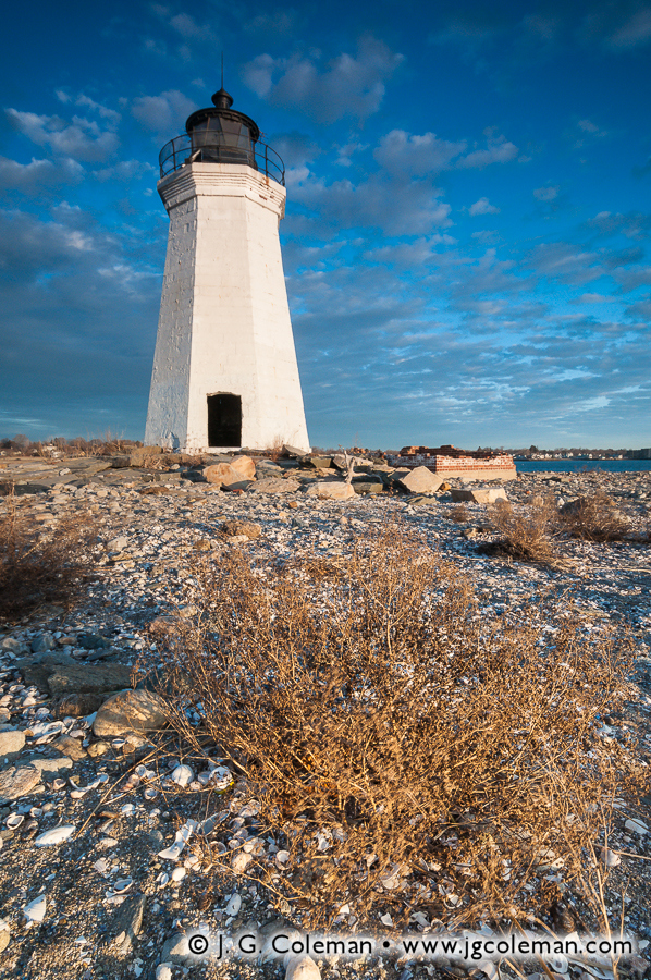
For nearly 200 years, the Black Rock Lighthouse has been perched upon Fayerweather Island just off the coast of Bridgeport, Connecticut, weathering countless hurricanes, blizzards, floods and even the tireless efforts of several generations of vandals. Against all odds, the Black Rock Light continues to watch over Long Island Sound to this very day, an enduring reminder of a bygone era of Connecticut maritime heritage.
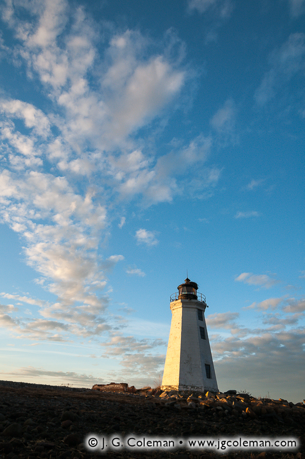
This iconic lighthouse of the Bridgeport coastline is featured in my new pieces, Fayerweather Daybreak (above) and Black Rock Crescendo (below), both of which feature the white hexagonal tower against the glorious light of dawn. Indeed, the Black Rock Light is quite a rare gem, especially when we consider that so much of the view of Bridgeport’s coastline in this area includes industrial buildings and factory smokestacks.
It may be interesting to note that, even though the Black Rock Light is situated on Fayerweather Island, it is one of the few lighthouses left in Connecticut that is accessible by the public on foot. Most of Connecticut’s off-shore lighthouses were constructed upon islands that are relatively distant from the coast, but when the Black Rock Light was built upon Fayerweather Island in the earlier half the 19th-century, it was a mere 1000 feet from the mainland. In fact, folks could even walk to the island on a sandbar that would emerge during low-tide. By 1880s, the decision was made to build a large stone breakwater over the existing sandbar, permanently linking the island to the mainland even during high tide.
The new breakwater would surely have been appreciated by lighthouse keepers and maintenance crews who could now easily move back and forth between the island and mainland without the need for a boat. But in 1933, when the lighthouse was officially decommissioned and essentially left abandoned, the breakwater became an avenue for vandals that gutted and routinely defaced the structure while the ravages of time and environment took their toll. Mercifully, two efforts at restoration were eventually launched, one in the 1980s and the other in the 1990s, which succeeded at stabilizing and beautifying the decaying structure.
Unfortunately, even with the lighthouse now being part and parcel to Bridgeport’s Seaside Park, vandalism remains an on-going issue. During the shoot that I produced Fayerweather Daybreak and Black Rock Crescendo, for example, I found the walls of the lighthouse scribbled with all manner of graffiti which I decided to painstakingly edit out of my final images. The result is that the lighthouse you see in these works is a bit idealized, at least in the sense that it is shown in the context of world where folks might be inclined to respect this old sentinel of Black Rock Harbor rather using it as a personal billboard.
Luckily, if spray paint is the only problem that the Black Rock Light needs to contend with, it’s likely to fare exceptionally well. Upon its completion in 1823, the builders of the Black Rock Light claimed that it had been constructed to “withstand the storm of ages”… so far, it’s done exactly that.
As part of J. G. Coleman’s Decor Series prints, all of the works seen here are available at Fine Art America. You are encouraged to visit his J. G. Coleman’s Fine Art America eStore, or see all of Fine Art America’s connecticut art.
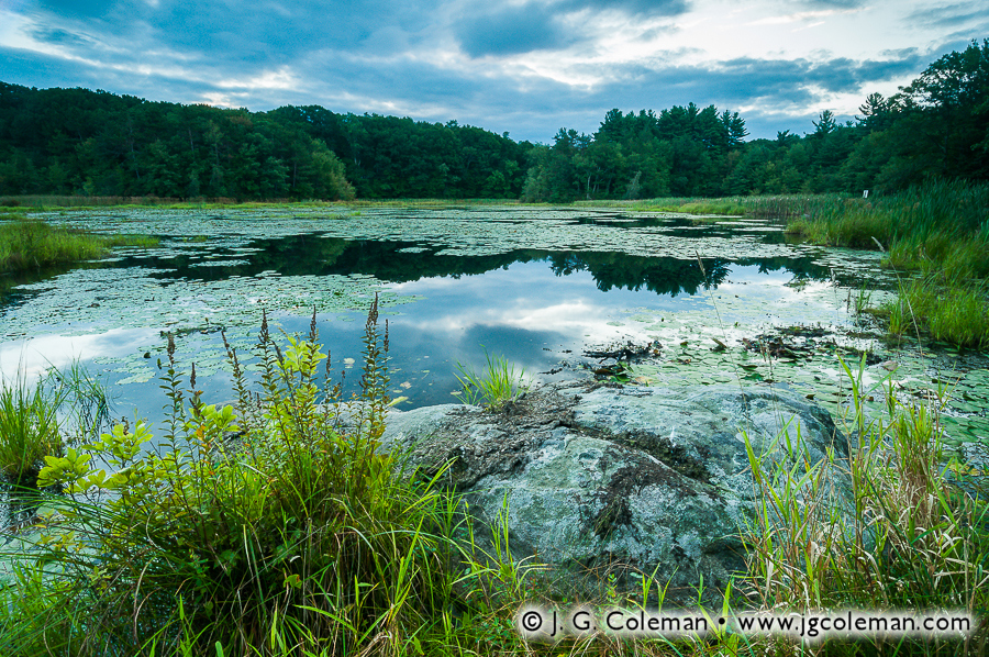
My new release this week, titled Juniper Hill Pondside, comes to you from Sperry Pond in the wooded northeastern corner of Middlebury, Connecticut. I learned of this small nature preserve not long after moving to Western Connecticut and I’ve since visited a few times throughout different seasons. On this particular morning in early September last year, I observed a beautifully moody display as the clouds sprawled across the sky over shadowy woodlands, reflecting from the mirror-like surface of Sperry Pond.
Juniper Hill Preserve was donated to the Middlebury Land Trust by Mark and Lem Sperry and certainly makes a handsome contribution to the town’s open spaces. The pond itself seems to be well on its way towards becoming more of a wetland than a proper pond, for aquatic plant life can be found crowding most of the surface by summertime. However, there’s no doubt that wildlife still manages to find plenty of habitat here. Hikers and nature lovers, for their own part, find a welcome respite at this quiet preserve on Sperry Pond.
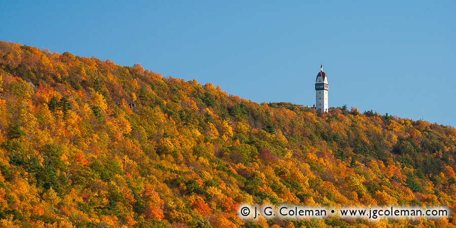
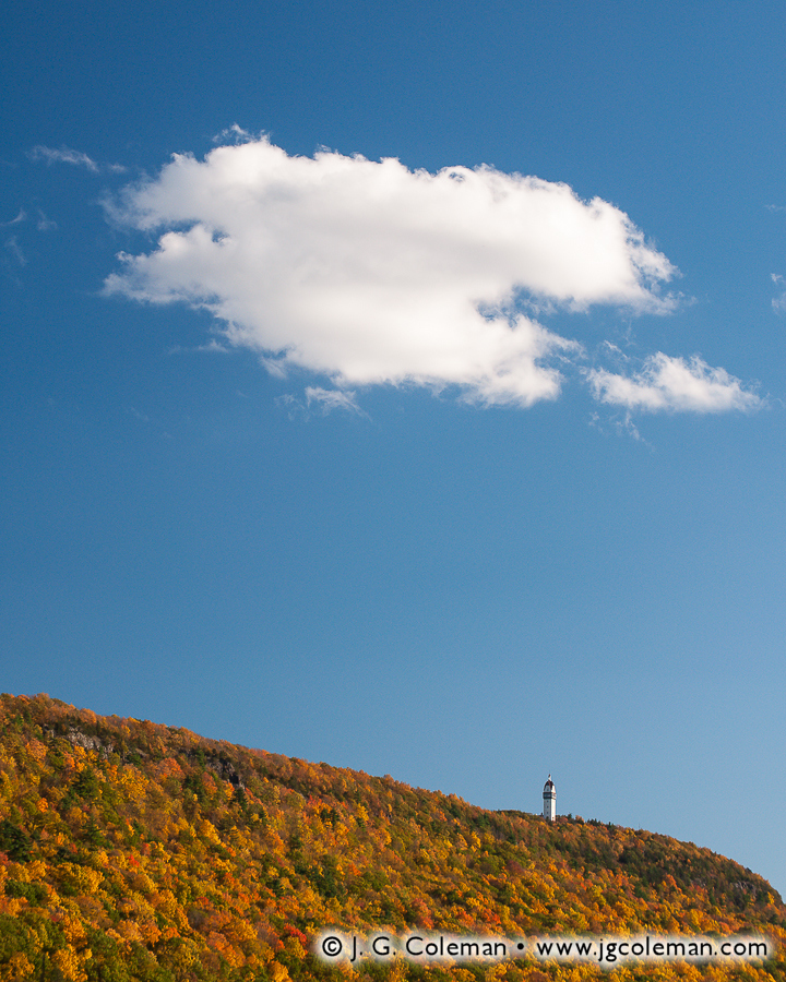
My newly-released piece, Hublein’s Retreat, offers a panoramic view of the autumn ridgeline on Talcott Mountain in the north of Connecticut. This image embraces a more simplistic view of nature, emphasizing two contrasting expanses of texture and color. The vivid forest canopy, grainy with millions of leaves donning their fall hues, climbs to reach the smooth, blue yonder above. Hublein Tower rises proudly from the ridge top, adding a sense of scale and helping to balance the otherwise abstract composition.
Spanning more than a dozen miles, Talcott Mountain is part and parcel to the Metacomet Range, a chain of long, narrow traprock ridges which extends from the Connecticut coast to the southern borders of Vermont and New Hampshire. Talcott Mountain can be seen from countless places throughout the towns of Bloomfield, Simsbury and Avon, its wooded slopes rising prominently above the surrounding landscape. And if there should be any doubt as to whether or not the commanding shape on the horizon is in fact Talcott, one can quickly scan the ridge line for the impressive Hublein Tower. Standing 165-feet tall upon the crest of the ridge, this beautiful tower is just as much a local landmark as the mountain itself.
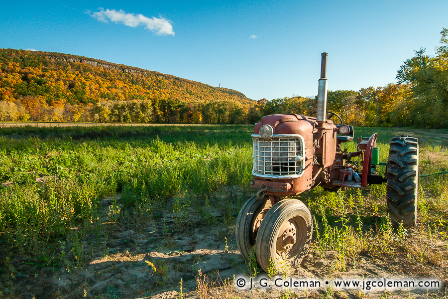
My piece, Talcott’s Crown, offers some insight into the reason why Hublein Tower is such an iconic structure. In this image, I’ve captured a magnificent and rather massive white cloud as it drifted slowly over Talcott Mountain. Although this is actually a very wide, sweeping view of the ridge and the sky, we can still easily pick out the tower perched upon the mountain top, its white walls practically glowing in the afternoon sunlight. We find an even wider view of the mountain in Talcott Mountain Rustic (below), which portrays a long stretch of the ridge on the horizon behind an old tractor. Remarkably, we can still discern the towering gleaming in the distance. In an era when so many of Connecticut’s prominent ridges are topped by decidedly unattractive cell and radio towers, its refreshing to see such a beautiful and unmistakable piece of architecture gracing the crest of Talcott Mountain.
Built in 1914, Hublein Tower was originally the summer home of Gilbert Hublein and his wife, Louise. In their younger days before the turn of the century, the couple had enjoyed taking walks on Talcott Mountain and, as the story goes, Gilbert promised Louise that he would one day build her a castle there. Since the Hublein family was actually quite wealthy, Gilbert was able to make good on that fairy-tale promise. At the time of its completion, the six-story Hublein Tower was a place of superlative luxury, including a spacious living room, three bedrooms with their own fireplaces, a cigar room and, at the very top, a window-lined ballroom that offered spectacular panoramic views of the surrounding countryside. As if that wasn’t enough, guests could be shuttled to the upper floor by what is believed to be the first elevator ever installed in a Connecticut home!
Hublein Tower enjoyed quite a storied past through the 1950s, far too voluminous to describe here. However, by the 1960s, the 450-acre property came under the ownership of a corporation that intended to convert the tower into a restaurant and develop the ridge as a suburban neighborhood. Thankfully the idea was vehemently opposed and sufficient money was raised to buy out the development rights. The land was eventually dubbed “Talcott Mountain State Park” and has since expanded to encompass well over 500 acres of land with a beautifully-restored Hublein Tower at its heart.
My piece above, “Talcott Mountain Rustic”, was exhibited in the 2013 Arts & Agriculture exhibition hosted by the Granby Land Trust. You can read more by revisiting my November 2013 blog post here on From the Field.
It’s difficult to overstate the degree to which life in Connecticut has changed since 1907. For instance, big cities such as Hartford and New Haven probably had limited access to electricity at that time, but it would be at least a decade before such a luxury appeared in the average Connecticut household. Folks of that era still had to light their houses at night by candle or lamp, heat their homes with wood and quarry their their ice from nearby lakes. The state was criss-crossed only by rough dirt roads and rails; local travel was by horse or horse-drawn carraige, while longer trips were by train. For the ordinary resident of Connecticut, travel was by no means impossible, but it was still difficult enough that you didn’t tend to leave town for the day unless their was a good reason to do so. Most people spent most of their waking lives within just a few miles of their home.
But why do I refer specifically to 1907? Well, that was the year that Sperry Park, the subject of my newly-released work, was created in the rural town of Woodbridge, Connecticut. And the reason that I’ve offered an account of life during that era is because we probably need a bit of context these days to understand why a small place like Sperry Park, at a size of only 4 acres, was once a celebrated town landmark.
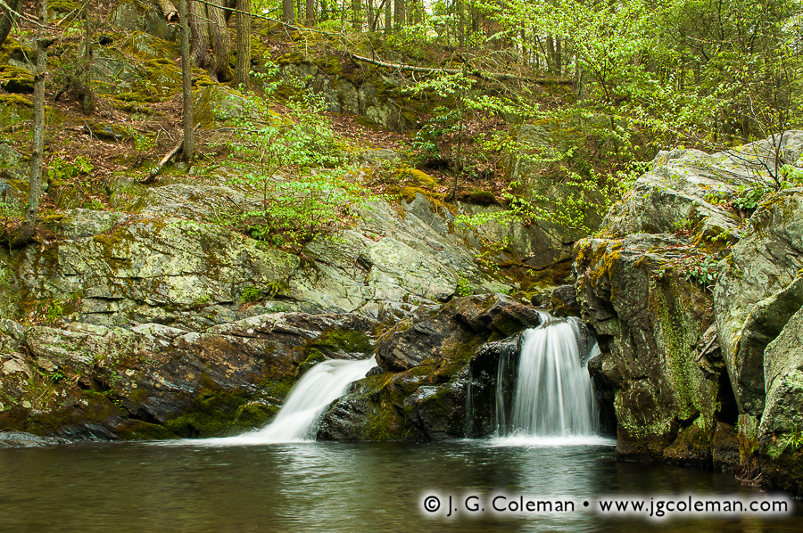
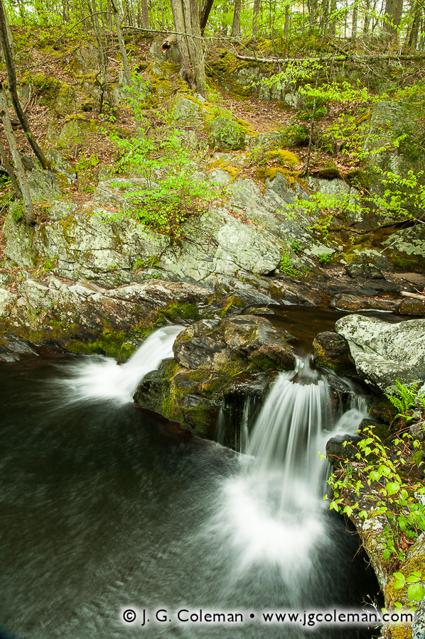
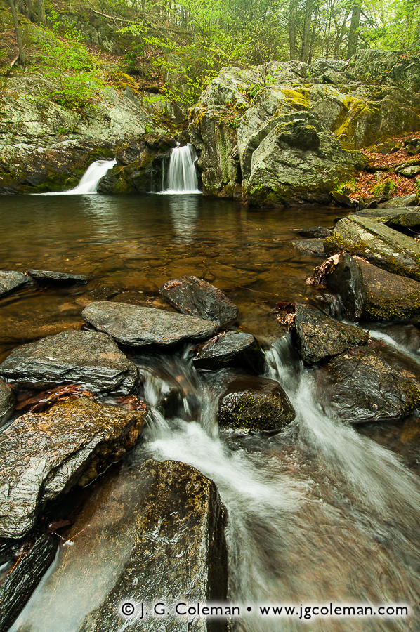
My piece, The Pride of Old Woodbridge (above), brings us to the aesthetic heart of Sperry Park: a calm, shady pool in the woods where the Sargent River is cleft into two sister waterfalls as it plunges some 6 feet over a shelf of weather-beaten bedrock. Hardy shrubs and trees grasp the faces of bare stone which rise from the river gorge and transition seamlessly into hilly forests blanketed by leaf litter. A few more of my pieces from Sperry Park are portrayed here, as well, so you can really get a feel for this lovely woodland oasis.
If Sperry Park strikes you as an exceptional place for a tranquil retreat into nature, then you can probably get a sense of why Nehemiah Sperry decided to donate this four-acre parcel of his family’s ancestral land to the Town of Woodbridge in 1907. At that time, he was an 80-year-old US Congressman and there must have been times that his memories drifted fondly to the old farm where he had grown up in the 1830s. For that matter, Sperry Falls had been passed down in the Sperry Family from generation to generation for nearly two centuries. In protecting a piece of that land as a park, Nehemiah was preserving the waterfalls that had been at the heart of Sperry family heritage for as far back as anybody could remember.
Of course, in modern times, a four-acre nature preserve seems awfully small. Indeed, it was not the sort of park where one could go hiking for hours on end, but then again, that wasn’t really what the people of Woodbridge needed. In the early years of the 20th-century, when life for the folks living in rural Woodbridge was centered mostly around town, Sperry Park was truly a treasured place where locals could go to relax and unwind without the difficulty of distant travel. Many publications from that era extolled the virtues of Sperry Park, with one hailing it as “the most celebrated natural feature of the town.”
In 1911, just a few years after donating Sperry Park to the town, Nehemiah passed away. Around the same time as his death, there also began the incidental decline of that rural way of life which he had known throughout the 19th-century. The famous Ford Model T had been introduced in 1908 and, by the 1920s, the price of automobiles had fallen to levels at which even ordinary middle class families could afford them. By the 1930s and 40s, it was easy for the people of Woodbridge to leave town for leisure. Amidst the flurry of changing times and a world that was growing ever smaller, Sperry Park was largely forgotten.
These days, the tiny park lies nestled within the vast, woodland watershed area of a few reservoirs in eastern Woodbridge. The public is still welcome to visit —a fact that would certainly make old Nehemiah proud— but few people venture out to see it anymore. As much as Sperry Park is a historic treasure to Woodbridge, it’s overall remoteness and proximity to public water supplies surely make it something of a liability, too. The result is that the park is quietly kept open for those rare few who learn of it by word of mouth or who stumble upon it while perusing a map. And, in truth, maybe that’s a good thing. A small, out-of-the-way park like Sperry simply cannot exist in this day in age unless its visitors bring along a healthy measure of respect for the landscape and a mindfulness that the origins of this place stretch deeply into the past… back to a simpler time when a few tranquil waterfalls on the Sargent River were the truly the pride of old Woodbridge.
“I wonder if the snow loves the trees and fields, that it kisses them so gently? And then it covers them up snug, you know, with a white quilt; and perhaps it says ‘Go to sleep, darlings, till the summer comes again.'”
-Lewis Carroll Alice’s Adventures in Wonderland (1865)
As we move into the month of March here in Connecticut, the sentiment among most folks is that we’ve had more than our fill of winter. Temperatures have remained anchored below freezing in spite of our advance towards springtime and we’ve found ourselves knee-deep in a persistent snowpack that has certainly overstayed its welcome.
I’ve observed that we here in Connecticut have an interesting relationship with winter. We are charmed by the aesthetic range of our landscape as it transitions from the dazzling displays of autumn to the contemplative dormancy of winter. But, without fail, early March finds us increasingly eager to escape the frigid temperatures and meager daylight that we’ve endured for months on end. Our winter wonderland starts to feel more like a winter wasteland, and in spite of our experience and good sense, there brews in the back of our minds an irrational concern that the snows might never melt and the trees might never again bear leaves.
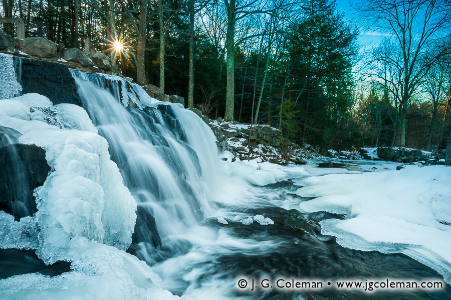
But with my new work, Winter on Eightmile Brook (above), I challenge us all to put aside our quarrels with the frigid weather, even if it’s only for a moment! Produced in Connecticut just last month, this piece brings us to the foot of Southford Falls where Eightmile Brook plunges a dozen feet before meandering through a snowy gorge that straddles the borders of Southbury and Oxford. The Sun hangs low on the horizon, peeking through the woodland canopy and imparting a feeling of warmth, even if there’s little it can do to banish the frigid air that has pooled in the gorge overnight. Winter on Eightmile Brook embraces all the icy bitterness of our tough winter and seeks to find something comforting —perhaps even inviting— in nature’s patient hibernation.
And don’t worry, friends… springtime is right around the corner!
To see more of my work featuring Southford Falls and Eightmile Brook, be sure to visit my Southford Falls State Park collection.
As part of J. G. Coleman’s Decor Series prints, all of the works seen here are available at Fine Art America. You are encouraged to visit J. G. Coleman’s Fine Art America eStore, or see all of Fine Art America’s snow art or forest art.
“The tempered light of the woods is like a perpetual morning, and is stimulating and heroic. The anciently reported spells of these places creep on us. The stems of pines, hemlocks, and oaks, almost gleam like iron on the excited eye.”
-Ralph Waldo Emerson (1844)
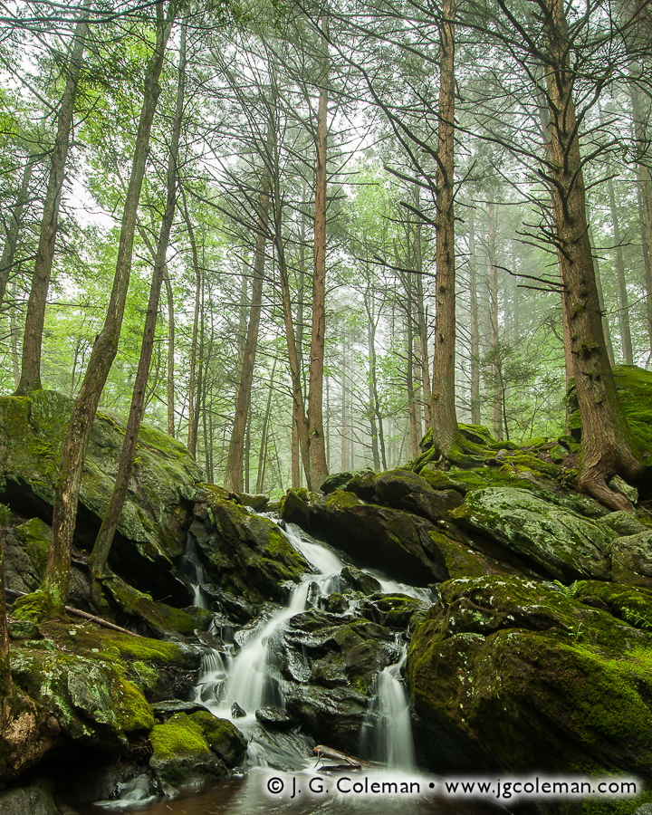
Nestled in the forests of Plymouth within Connecticut’s Central Naugatuck Valley, Buttermilk Falls Preserve is among those small and relatively obscure nature preserves that most of us will never set foot upon. It’s not that there’s anything stopping us, mind you; the public is welcome anytime to visit this shady grove of hemlocks that crowd the boulder-laden banks of Hancock Brook. It’s simply that, at a size of only a dozen acres, folks tend to assume that this diminutive swath of open space is just not worth the trip.
As part of my years-long project to capture in photographs the aesthetic essence of Connecticut’s waterfalls, I became familiar with Buttermilk Falls Preserve in the Summer of 2011. In fact, I was so impressed with its incredible beauty and arresting atmosphere that I’ve returned several times since then. My goal has been simple: to catch conditions that help me tell the story of this jewel in a way that is befitting of the magical impression it makes upon its visitors. As it would happen, I managed to get out to the Preserve on an early May morning last year as a dense fog drifted through the forest, producing subtle tones and contrasts that brought to the surface what Emerson would have called the “anciently reported spells” that linger in the wilds of Buttermilk Falls.
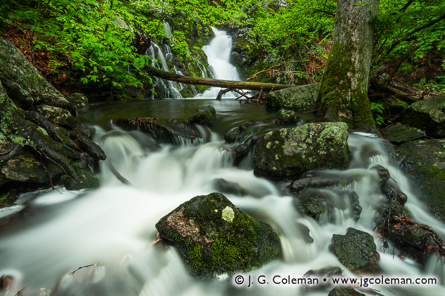
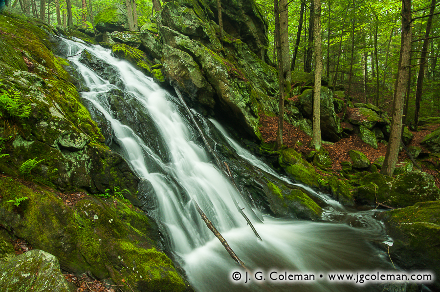
One of the pieces that emerged from that morning, Plymouth Wildlands (photo at top), brings us to a magnificent whitewater cataract on Hancock Brook. Plummeting more than 50 feet over a steep rock face, Buttermilk Falls is the namesake landmark of the Preserve, as well as its aesthetic epicenter. This glade feels like some verdant amphitheater where soft light filters through the greenery of the hemlocks overhead and every surface of the forest understory lays cloaked in a generous blanket of moss and ferns.
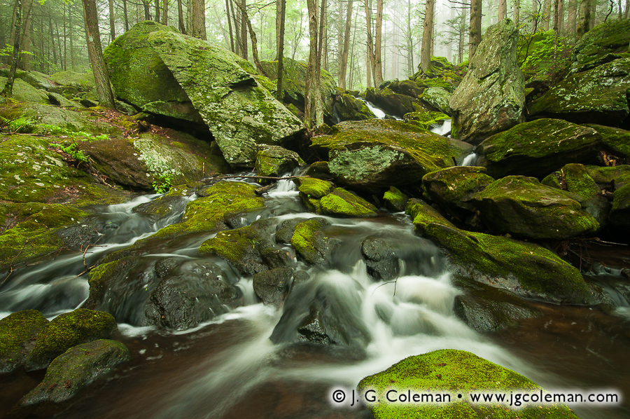
Another of my works, Hymn of the Hemlocks (above), takes us upstream from the falls and into the imposing vertical expanse of the seemingly primeval woodlands that envelop Hancock Brook. We find ourselves surrounded by towering hemlocks, most perched mightily upon bare rock, that cast whorls of wizened branches into the air as they reach skywards from the shadowy gorge for a taste of precious sunlight.
Finally, in Hancock Cascades, we find ourselves squarely in the middle of Hancock Brook, almost as if we are wading barefoot in its cool waters. Peering ahead, we watch the stream spread and splinter into myriad cascades as it struggles to clear ancient boulders and weather-scarred bedrock. Wherever the water cannot reach, the mosses have staked their claim, thriving amidst the cool, moist air that settles in troughs of the gorge.
Rendered in a written chronology, the story of Buttermilk Falls is long and varied. People have enacted their influence upon this place for centuries, if not millennia, and there’s little doubt that the landscape has been shaped and re-shaped by the rigors of time and water. But for me, all of those disparate verses of bygone times found a focused voice in the tranquil mists that drifted over Hancock Brook on a quiet morning in May.
Want to See More?
To see more of my work from Buttermilk Falls or buy a fine art print of the pieces introduced here, be sure to visit the Buttermilk Falls collection at my online galleries.