Categories
All Things Connecticut New Print Releases

Hublein’s Retreat

Hublein's Retreat (Hublein Tower on Talcott Mountain, Talcott Mountain State Park, Simsbury, Connecticut)
“Hublein’s Retreat”
Hublein Tower on Talcott Mountain, Talcott Mountain State Park, Simsbury, Connecticut
© 2014 J. G. Coleman

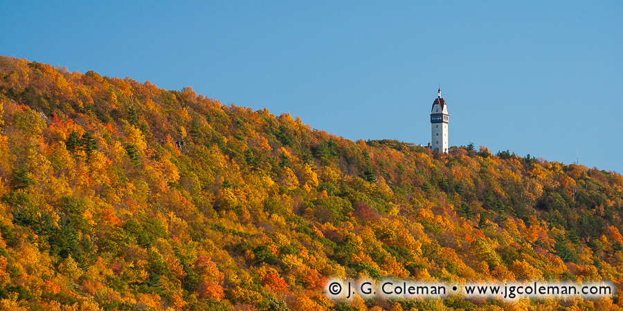
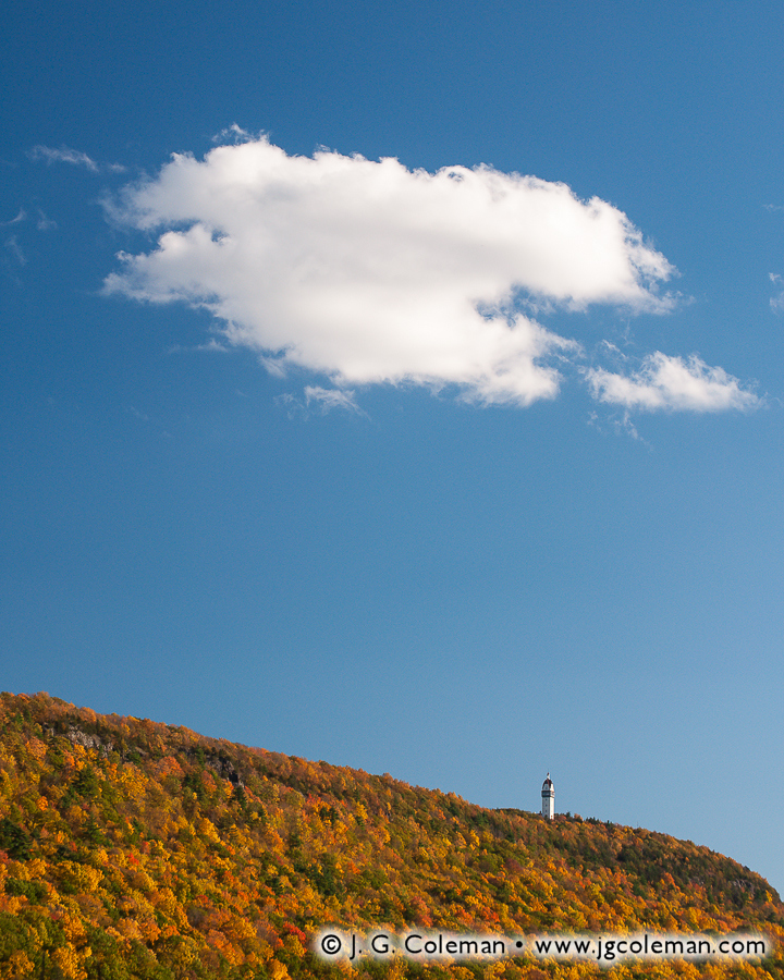
My newly-released piece, Hublein’s Retreat, offers a panoramic view of the autumn ridgeline on Talcott Mountain in the north of Connecticut. This image embraces a more simplistic view of nature, emphasizing two contrasting expanses of texture and color. The vivid forest canopy, grainy with millions of leaves donning their fall hues, climbs to reach the smooth, blue yonder above. Hublein Tower rises proudly from the ridge top, adding a sense of scale and helping to balance the otherwise abstract composition.

Spanning more than a dozen miles, Talcott Mountain is part and parcel to the Metacomet Range, a chain of long, narrow traprock ridges which extends from the Connecticut coast to the southern borders of Vermont and New Hampshire. Talcott Mountain can be seen from countless places throughout the towns of Bloomfield, Simsbury and Avon, its wooded slopes rising prominently above the surrounding landscape. And if there should be any doubt as to whether or not the commanding shape on the horizon is in fact Talcott, one can quickly scan the ridge line for the impressive Hublein Tower. Standing 165-feet tall upon the crest of the ridge, this beautiful tower is just as much a local landmark as the mountain itself.

Talcott's Crown (Hublein Tower on Talcott Mountain, Talcott Mountain State Park, Simsbury, Connecticut)
“Talcott’s Crown”
Hublein Tower on Talcott Mountain, Talcott Mountain State Park, Simsbury, Connecticut
© 2014 J. G. Coleman

My piece, Talcott’s Crown, offers some insight into the reason why Hublein Tower is such an iconic structure. In this image, I’ve captured a magnificent and rather massive white cloud as it drifted slowly over Talcott Mountain. Although this is actually a very wide, sweeping view of the ridge and the sky, we can still easily pick out the tower perched upon the mountain top, its white walls practically glowing in the afternoon sunlight. We find an even wider view of the mountain in Talcott Mountain Rustic (below), which portrays a long stretch of the ridge on the horizon behind an old tractor. Remarkably, we can still discern the towering gleaming in the distance. In an era when so many of Connecticut’s prominent ridges are topped by decidedly unattractive cell and radio towers, its refreshing to see such a beautiful and unmistakable piece of architecture gracing the crest of Talcott Mountain.

Talcott Mountain Rustic (Fields beside Talcott Mountain State Park, Simsbury, Connecticut)
“Talcott Mountain Rustic”
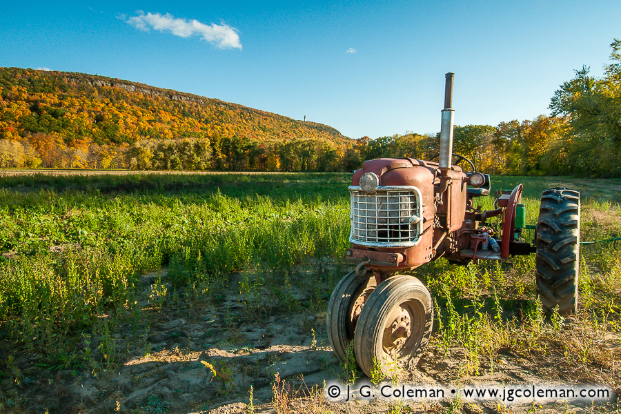
Fields near Talcott Mountain State Park, Simsbury, Connecticut
© 2014 J. G. Coleman

Built in 1914, Hublein Tower was originally the summer home of Gilbert Hublein and his wife, Louise. In their younger days before the turn of the century, the couple had enjoyed taking walks on Talcott Mountain and, as the story goes, Gilbert promised Louise that he would one day build her a castle there. Since the Hublein family was actually quite wealthy, Gilbert was able to make good on that fairy-tale promise. At the time of its completion, the six-story Hublein Tower was a place of superlative luxury, including a spacious living room, three bedrooms with their own fireplaces, a cigar room and, at the very top, a window-lined ballroom that offered spectacular panoramic views of the surrounding countryside. As if that wasn’t enough, guests could be shuttled to the upper floor by what is believed to be the first elevator ever installed in a Connecticut home!

Hublein Tower enjoyed quite a storied past through the 1950s, far too voluminous to describe here. However, by the 1960s, the 450-acre property came under the ownership of a corporation that intended to convert the tower into a restaurant and develop the ridge as a suburban neighborhood. Thankfully the idea was vehemently opposed and sufficient money was raised to buy out the development rights. The land was eventually dubbed “Talcott Mountain State Park” and has since expanded to encompass well over 500 acres of land with a beautifully-restored Hublein Tower at its heart.

Want to See More?

Categories
All Things Connecticut New Print Releases

The Pride of Old Woodbridge

The Pride of Old Woodbridge (Sperry Falls on Sargent River, Sperry Park, Woodbridge, CT)

It’s difficult to overstate the degree to which life in Connecticut has changed since 1907. For instance, big cities such as Hartford and New Haven probably had limited access to electricity at that time, but it would be at least a decade before such a luxury appeared in the average Connecticut household. Folks of that era still had to light their houses at night by candle or lamp, heat their homes with wood and quarry their their ice from nearby lakes. The state was criss-crossed only by rough dirt roads and rails; local travel was by horse or horse-drawn carraige, while longer trips were by train. For the ordinary resident of Connecticut, travel was by no means impossible, but it was still difficult enough that you didn’t tend to leave town for the day unless their was a good reason to do so. Most people spent most of their waking lives within just a few miles of their home.

Gorge on the Sargent River (Sperry Falls on Sargent River, Sperry Park, Woodbridge, CT)

But why do I refer specifically to 1907? Well, that was the year that Sperry Park, the subject of my newly-released work, was created in the rural town of Woodbridge, Connecticut. And the reason that I’ve offered an account of life during that era is because we probably need a bit of context these days to understand why a small place like Sperry Park, at a size of only 4 acres, was once a celebrated town landmark.

My piece, The Pride of Old Woodbridge (above), brings us to the aesthetic heart of Sperry Park: a calm, shady pool in the woods where the Sargent River is cleft into two sister waterfalls as it plunges some 6 feet over a shelf of weather-beaten bedrock. Hardy shrubs and trees grasp the faces of bare stone which rise from the river gorge and transition seamlessly into hilly forests blanketed by leaf litter. A few more of my pieces from Sperry Park are portrayed here, as well, so you can really get a feel for this lovely woodland oasis.

If Sperry Park strikes you as an exceptional place for a tranquil retreat into nature, then you can probably get a sense of why Nehemiah Sperry decided to donate this four-acre parcel of his family’s ancestral land to the Town of Woodbridge in 1907. At that time, he was an 80-year-old US Congressman and there must have been times that his memories drifted fondly to the old farm where he had grown up in the 1830s. For that matter, Sperry Falls had been passed down in the Sperry Family from generation to generation for nearly two centuries. In protecting a piece of that land as a park, Nehemiah was preserving the waterfalls that had been at the heart of Sperry family heritage for as far back as anybody could remember.

Nehemiah's Gift (Sperry Falls on Sargent River, Sperry Park, Woodbridge, CT)

Of course, in modern times, a four-acre nature preserve seems awfully small. Indeed, it was not the sort of park where one could go hiking for hours on end, but then again, that wasn’t really what the people of Woodbridge needed. In the early years of the 20th-century, when life for the folks living in rural Woodbridge was centered mostly around town, Sperry Park was truly a treasured place where locals could go to relax and unwind without the difficulty of distant travel. Many publications from that era extolled the virtues of Sperry Park, with one hailing it as “the most celebrated natural feature of the town.”

In 1911, just a few years after donating Sperry Park to the town, Nehemiah passed away. Around the same time as his death, there also began the incidental decline of that rural way of life which he had known throughout the 19th-century. The famous Ford Model T had been introduced in 1908 and, by the 1920s, the price of automobiles had fallen to levels at which even ordinary middle class families could afford them. By the 1930s and 40s, it was easy for the people of Woodbridge to leave town for leisure. Amidst the flurry of changing times and a world that was growing ever smaller, Sperry Park was largely forgotten.

Woodland Violets (Sperry Falls on Sargent River, Sperry Park, Woodbridge, CT)

These days, the tiny park lies nestled within the vast, woodland watershed area of a few reservoirs in eastern Woodbridge. The public is still welcome to visit —a fact that would certainly make old Nehemiah proud— but few people venture out to see it anymore. As much as Sperry Park is a historic treasure to Woodbridge, it’s overall remoteness and proximity to public water supplies surely make it something of a liability, too. The result is that the park is quietly kept open for those rare few who learn of it by word of mouth or who stumble upon it while perusing a map. And, in truth, maybe that’s a good thing. A small, out-of-the-way park like Sperry simply cannot exist in this day in age unless its visitors bring along a healthy measure of respect for the landscape and a mindfulness that the origins of this place stretch deeply into the past… back to a simpler time when a few tranquil waterfalls on the Sargent River were the truly the pride of old Woodbridge.

Want to See More?

Categories
All Things Connecticut New Print Releases

Winter on the Eightmile

Winter on the Eightmile (Southford Falls State Park, Southbury, Connecticut)
“Winter on the Eightmile”
Southford Falls on Eightmile Brook, Southford Falls State Park, Southbury, Connecticut
© 2014 J. G. Coleman

“I wonder if the snow loves the trees and fields, that it kisses them so gently? And then it covers them up snug, you know, with a white quilt; and perhaps it says ‘Go to sleep, darlings, till the summer comes again.'”

-Lewis Carroll
Alice’s Adventures in Wonderland (1865)

As we move into the month of March here in Connecticut, the sentiment among most folks is that we’ve had more than our fill of winter. Temperatures have remained anchored below freezing in spite of our advance towards springtime and we’ve found ourselves knee-deep in a persistent snowpack that has certainly overstayed its welcome.

I’ve observed that we here in Connecticut have an interesting relationship with winter. We are charmed by the aesthetic range of our landscape as it transitions from the dazzling displays of autumn to the contemplative dormancy of winter. But, without fail, early March finds us increasingly eager to escape the frigid temperatures and meager daylight that we’ve endured for months on end. Our winter wonderland starts to feel more like a winter wasteland, and in spite of our experience and good sense, there brews in the back of our minds an irrational concern that the snows might never melt and the trees might never again bear leaves.

But with my new work, Winter on Eightmile Brook (above), I challenge us all to put aside our quarrels with the frigid weather, even if it’s only for a moment! Produced in Connecticut just last month, this piece brings us to the foot of Southford Falls where Eightmile Brook plunges a dozen feet before meandering through a snowy gorge that straddles the borders of Southbury and Oxford. The Sun hangs low on the horizon, peeking through the woodland canopy and imparting a feeling of warmth, even if there’s little it can do to banish the frigid air that has pooled in the gorge overnight. Winter on Eightmile Brook embraces all the icy bitterness of our tough winter and seeks to find something comforting —perhaps even inviting— in nature’s patient hibernation.

And don’t worry, friends… springtime is right around the corner!

Want to See More?

As part of J. G. Coleman’s Decor Series prints, all of the works seen here are available at Fine Art America. You are encouraged to visit J. G. Coleman’s Fine Art America eStore, or see all of Fine Art America’s snow art or forest art.

Categories
All Things Connecticut New Print Releases

Plymouth Wildlands

Plymouth Wildlands (Buttermilk Falls, Buttermilk Falls Preserve, Plymouth, Connecticut)
“Plymouth Wildlands”
Buttermilk Falls on Hancock Brook,
Buttermilk Falls Preserve, Plymouth, Connecticut
©2013 J. G. Coleman

“The tempered light of the woods is like a perpetual morning, and is stimulating and heroic. The anciently reported spells of these places creep on us. The stems of pines, hemlocks, and oaks, almost gleam like iron on the excited eye.”

-Ralph Waldo Emerson (1844)

Nestled in the forests of Plymouth within Connecticut’s Central Naugatuck Valley, Buttermilk Falls Preserve is among those small and relatively obscure nature preserves that most of us will never set foot upon. It’s not that there’s anything stopping us, mind you; the public is welcome anytime to visit this shady grove of hemlocks that crowd the boulder-laden banks of Hancock Brook. It’s simply that, at a size of only a dozen acres, folks tend to assume that this diminutive swath of open space is just not worth the trip.

As part of my years-long project to capture in photographs the aesthetic essence of Connecticut’s waterfalls, I became familiar with Buttermilk Falls Preserve in the Summer of 2011. In fact, I was so impressed with its incredible beauty and arresting atmosphere that I’ve returned several times since then. My goal has been simple: to catch conditions that help me tell the story of this jewel in a way that is befitting of the magical impression it makes upon its visitors. As it would happen, I managed to get out to the Preserve on an early May morning last year as a dense fog drifted through the forest, producing subtle tones and contrasts that brought to the surface what Emerson would have called the “anciently reported spells” that linger in the wilds of Buttermilk Falls.

Hymn of the Hemlocks (Hancock Brook, Buttermilk Falls Preserve, Plymouth, CT)
“Hymn of the Hemlocks”
Hancock Brook, Buttermilk Falls Preserve, Plymouth, Connecticut
©2014 J. G. Coleman

One of the pieces that emerged from that morning, Plymouth Wildlands (photo at top), brings us to a magnificent whitewater cataract on Hancock Brook. Plummeting more than 50 feet over a steep rock face, Buttermilk Falls is the namesake landmark of the Preserve, as well as its aesthetic epicenter. This glade feels like some verdant amphitheater where soft light filters through the greenery of the hemlocks overhead and every surface of the forest understory lays cloaked in a generous blanket of moss and ferns.

Another of my works, Hymn of the Hemlocks (above), takes us upstream from the falls and into the imposing vertical expanse of the seemingly primeval woodlands that envelop Hancock Brook. We find ourselves surrounded by towering hemlocks, most perched mightily upon bare rock, that cast whorls of wizened branches into the air as they reach skywards from the shadowy gorge for a taste of precious sunlight.

Hancock Cascades (Hancock Brook at Buttermilk Falls Preserve, Plymouth, Connecticut)
“Hancock Cascades”
Hancock Brook at Buttermilk Falls Preserve, Plymouth, Connecticut
©2013 J. G. Coleman

Finally, in Hancock Cascades, we find ourselves squarely in the middle of Hancock Brook, almost as if we are wading barefoot in its cool waters. Peering ahead, we watch the stream spread and splinter into myriad cascades as it struggles to clear ancient boulders and weather-scarred bedrock. Wherever the water cannot reach, the mosses have staked their claim, thriving amidst the cool, moist air that settles in troughs of the gorge.

Rendered in a written chronology, the story of Buttermilk Falls is long and varied. People have enacted their influence upon this place for centuries, if not millennia, and there’s little doubt that the landscape has been shaped and re-shaped by the rigors of time and water. But for me, all of those disparate verses of bygone times found a focused voice in the tranquil mists that drifted over Hancock Brook on a quiet morning in May.

Want to See More?

To see more of my work from Buttermilk Falls or buy a fine art print of the pieces introduced here, be sure to visit the Buttermilk Falls collection at my online galleries.

Categories
All Things Connecticut New Print Releases

Grayville Everlasting

Grayville Everlasting (Grayville Falls, Hebron, Connecticut)
“Grayville Everlasting”
Grayville Falls Park, Hebron, Connecticut
©2014 J. G. Coleman

“A brook there is all children know,
Upon whose banks the wild flowers grow;
A brook that from its hill runs down,
And wanders wanders past the town.”

-Susan Pendleton
“Hebron” (1908)

Grayville Falls is a hidden gem nestled in the wooded wildlands of Hebron, a small town which bridges the low-lying Connecticut River Valley to its west and the hilly uplands of Connecticut’s “Quiet Corner” to its east. Although these falls had been on my must-see list for a few years, my attention was somehow routinely pulled elsewhere even as I passed within only a few miles on my way to shoot at more distant locations. It wasn’t until last summer when I finally managed to get out to the forests of Hebron on a warm July morning to visit Grayville Falls for the first time.

Grayville Everlasting (above), one of my pieces from that shoot, embraces the essence of these tranquil cascades on Raymond Brook, beginning with their steady persistence. Over thousands of years, Grayville Falls has ceaselessly carved its way deeper and deeper through several feet of stratified bedrock, leaving shadowy recesses along the periphery of the brook where weaker layers of stone have been gouged out by running water.

Grayville Riverscape (Grayville Falls, Hebron, Connecticut)
“Grayville Riverscape”
Grayville Falls Park, Hebron, Connecticut
© 2014 J. G. Coleman

There’s also a measure of human history to be found at Grayville Falls, as evidenced by the remnants of a large boulder dam that rises over the cascades in Grayville Everlasting. In Hebron’s earlier days, when industry was still tethered to water power as the sole means of animating machinery, William Gray operated a carpet factory along the banks of Raymond Brook. The dam ruins we find today suggest that Gray utilized a fairly crude dam constructed of boulders and earthen mortar to impound several thousands of gallons of water upstream, ensuring that his factory could run even during dry spells.

Interestingly, old William Gray wouldn’t have recognized the name “Grayville Falls” during his lifetime. That name didn’t appear until the 1970s, when Hebron purchased the property for use as parkland and held a town-wide contest to determine what it would be called. “Grayville Falls Park” emerged as the winning name; a clever tip of the hat to a man that might otherwise have been lost to history.

Want to See More?

To buy a fine art print of the pieces introduced here, or view more work for this location, be sure to visit Grayville Falls Park at my online galleries.

Categories
All Things Connecticut New Print Releases

A Bend on the Pomperaug

ALT-TEXT
“Bergamot Sunrise”
Bent of the River Audubon Sanctuary, Southbury, Connecticut
© 2013 J. G. Coleman

“Be like the sun and meadow, which are not in the least concerned about the coming winter.”

-George Bernard Shaw

Wildflowers are something of a staple subject for landscape photographers, not only for their vibrant color, but also for their exquisite structure. For while we can certainly find exceptional colors in a sunset sky or an autumn forest, neither can offer quite the same delicate complexity as wildflowers. However, incorporating wildflowers into an effective landscape photograph can be challenging. Timing is everything. Not only must a landscape photographer seek out conditions that are universally important for aesthetics, but he must also be especially attentive to the season in which certain species bloom. The trick is to seize those rare moments when weather, lighting, location and seasonal blooms intersect; that sweet spot is elusive, but it can potentially yield idyllic scenery.

Such was the case when I stepped out into the verdant meadows of Bent of the River Audubon Sanctuary earlier this year on a warm, humid morning in mid-July. Here, along the serpentine course of the Pomperaug River in Southbury, Connecticut, an exquisite wildflower known as wild bergamot had sprung forth in full bloom, dotting the fields with conspicuous sprays of blue. In one of the pieces I produced that morning, titled Bergamot Sunrise (at top), we can feel the warmth of the freshly-risen sun over our shoulder as it paints a lush green landscape with the bold light of dawn. But within this wonderland of lively foliage, it is the subtle, dew-kissed bergamot flowers that seem to invite us into the scene, only afterwards directing our eyes to travel elsewhere: to the curled leaves of milkweed at their side, then to the illumined edifice of the nearby forest and finally to the lone pasture tree in the distance, its trunk enshrouded in mist.

ALT-TEXT
“Pomperaug Summer”
Bent of the River Audubon Sanctuary, Southbury, Connecticut
© 2013 J. G. Coleman

Similar elements come together in a much different composition in Pomperaug Summer (at right), in which clusters of bergamot extend deeply into a meadow, mirroring in small scale the crown of the solitary, whimsical pasture tree that stands silhouetted against the distant, fog-laden forest.

Encompassing roughly a square mile of territory beside the Pomperaug River in Southbury and criss-crossed with some 15 miles of trails, Bent of the River Audubon Sanctuary is actually larger than many of Connecticut’s state parks! Quiet, forested hills cover most of the expansive property, while the area nearby the visitor center consists of the broad, open meadowlands portrayed here in my work. But if the scenic qualities of this place are readily evident, what is not so obvious is the story behind it’s perplexing name.

For nearly six decades prior to its ownership by the Audubon Society, much of the land was the private estate of Howard and Althea Clark. At some point, while perusing the old land records associated with property, they discovered an early 1702 deed that referred to a sharp turn of the Pomperaug River beside their driveway as “ye bent of ye river”. Passionate as the two were about living out in the countryside, surrounded by hundreds of acres of serene seclusion, it may well be that the Clarks found something romantic and nostalgic in this old-fashioned language, suggestive as it is of colonial-era New England. The novel reference made enough of an impression upon the couple that, when Althea passed away in 1992 and left the full extent of the property to the Audubon Society, one of her posthumous demands was that it should be called “Bent of the River”.

Although the Clarks were indeed wealthy, they seem to have accumulated this wealth early in life and were subsequently able to indulge in various artistic and literary pursuits. Howard managed to become a novelist and published at least a few books. For her own part, Althea enthusiastically took to photography, an art at which she is said to have excelled. Try as I may, I was unable to find any example of her work online. But given the bucolic surroundings in which she and Howard chose to live, it isn’t unreasonable to imagine that landscapes factored into her subject matter quite frequently. Indeed, I wonder if one day I might finally happen upon some of her old black-and-white prints and maybe… just maybe… I might find among them some vista of a broad, open meadow, sprinkled ever so delicately with sprays of wild bergamot.

Want to See More?

Categories
All Things Connecticut New Print Releases

Into the Tunxis Forest

Falls Brook Awakening (Falls Brook, Tunxis State Forest, Hartland, CT)
“Falls Brook Awakening”
Falls Brook, Tunxis State Forest, Hartland, CT
© 2013 J. G. Coleman

While traveling throughout Connecticut and Greater New England to photograph our diverse landscapes, I am constantly striving to produce visions of nature that convey a distinct sense of place. Wildlands never fail to inspire in me a range of emotional responses -from awe and joy, to nostalgia and melancholy- and I seek to distill those reactions into potent visual expressions. Indeed, the interpretive approach to landscape photography forms its very foundation as an art form. “Falls Brook Awakening”, my latest piece, exemplifies the sort of engaging and emotive perspectives that are possible when we’re receptive to the subtle character of the land.

In “Falls Brook Awakening”, we find ourselves deep in the forests of Hartland, Connecticut, peering downstream as Falls Brook wanders excitedly through a mossy gorge of boulders and bedrock. We are at first greeted by a lively waterfall coursing over a weathered ledge, and as we follow Falls Brook into the distance, we discover that its waters glow with vibrant reflections of the woodland canopy above. In the distance, crowded spring foliage is illumined by the luxurious light of early morning. The entire landscape is waking up from its nighttime slumber and we get the front row seat.

Falls Brook is really just a small taste of the natural treasures contained in Connecticut’s vast Tunxis State Forest. Encompassing more than 9,000 acres and spread across three towns, the Forest’s expansive wooded landscapes possess a truly wild character that permeates the body and soul alike.

Categories
All Things Connecticut New Print Releases

The Falls of Burlington

The Falls of Burlington (Burlington, Connecticut)
“The Falls of Burlington”
Bunnell Brook, Burlington, CT
© 2013 J. G. Coleman

My new piece, “The Falls of Burlington”, features a stretch of exquisite cascades along Bunnell Brook which churn ceaselessly over rock outcroppings beneath the shade of a dense forest canopy. If we follow the wispy whitewater upstream, through a jagged rock gorge softened by carpets of moss, we catch a glimpse of early morning light as it sets leaves aglow on the distant horizon.

While these falls have long been known to a handful of locals in Burlington and adjacent towns, it would seem that they never received any official name and you won’t have any luck finding them on a typical map. Instead, they’ve remained a sparsely-visited gem known simply as “The Falls”. The writers of the Burlington Rambler’s Guide, a sort of source book for the natural sights of Burlington, referred to them a bit more precisely as Burlington Falls, though they noted that “we’re not sure if that’s the official name.” So although there may be some measure of confusion over exactly what they ought to be called, Burlington Falls certainly imparts a clarity that can only come from spending time in the woodlands serenaded by the sounds of rushing water.